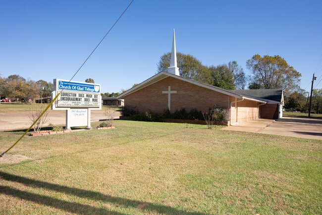
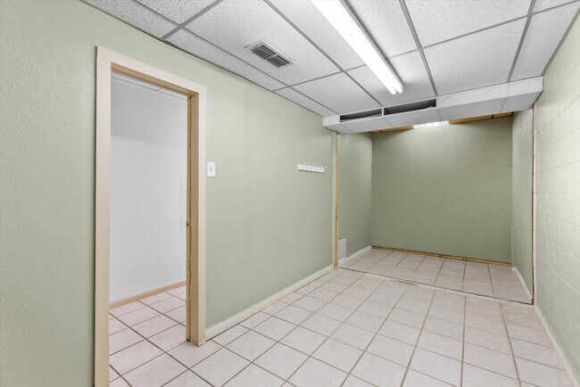
Property Record
201 Ragland St, Palestine, TX 75803

Property Detail
201 Ragland St
Palestine, TX
Glad Tidings Addn
R42027
GLAD TIDINGS ADDN LOT 1R
Taxexempt
Anderson
X
Texas
48001C0415D
1r
2025
1.14 AC
2025
Texas East Area
950500
Other Market Areas
5,508 SF
NEARBY LISTINGS FOR SALE OR LEASE
-
-
View all Palestine listings for sale on LoopNet.com
DEMOGRAPHICS near 201 Ragland St
1 mile
3 mile
5 mile
2024 Total Population
1,725
11,790
22,970
2029 Population
1,728
11,914
23,205
Pop Growth 2024-2029
+ 0.17%
+ 1.05%
+ 1.02%
Average Age
41
39
39
2024 Total Households
645
4,404
7,733
HH Growth 2024-2029
+ 0.16%
+ 0.98%
+ 0.98%
Median Household Inc
$47,386
$39,711
$41,494
Avg Household Size
2.60
2.60
2.60
2024 Avg HH Vehicles
2.00
2.00
2.00
Median Home Value
$90,207
$109,467
$119,278
Median Year Built
1978
1973
1979
Nearby Places
Map Layers
Map Styles
 Street
 Aerial
Transit
 Traffic
 Biking
Places
Listings with unknown addresses are not visible on the map
- Restaurants
- Banks
- Shops
- Fitness
- Groceries
SALE & LEASE HISTORY
LISTING DATE
SALE/LEASE

Nov 30, 2023
For Sale
Jul 13, 2022
For Sale
Aug 14, 2023
For Sale
Nearby Properties
Address
Land Use
TOTAL SIZE
Lot Size
Zoning
Address
Land Use
TOTAL SIZE
Lot Size
Zoning
79,260 SF
4.99 AC
Address
Land Use
TOTAL SIZE
Lot Size
Zoning
74,694 SF
14.56 AC
Address
Land Use
TOTAL SIZE
Lot Size
Zoning
69,685 SF
18.10 AC
Address
Land Use
TOTAL SIZE
Lot Size
Zoning
37,096 SF
3.39 AC
Address
Land Use
TOTAL SIZE
Lot Size
Zoning
114,935 SF
27.25 AC
Address
Land Use
TOTAL SIZE
Lot Size
Zoning
53,465 SF
7.49 AC
Address
Land Use
TOTAL SIZE
Lot Size
Zoning
36,849 SF
6.22 AC
Address
Land Use
TOTAL SIZE
Lot Size
Zoning
35,585 SF
2.28 AC
Address
Land Use
TOTAL SIZE
Lot Size
Zoning
63,184 SF
2.82 AC
Address
Land Use
TOTAL SIZE
Lot Size
Zoning
27,014 SF
2.70 AC
Address
Land Use
TOTAL SIZE
Lot Size
Zoning
35,808 SF
2.32 AC
Address
Land Use
TOTAL SIZE
Lot Size
Zoning
43,392 SF
2.38 AC
Address
Land Use
TOTAL SIZE
Lot Size
Zoning
40,554 SF
9.71 AC
Address
Land Use
TOTAL SIZE
Lot Size
Zoning
36,294 SF
19.78 AC
Address
Land Use
TOTAL SIZE
Lot Size
Zoning
28,107 SF
5.34 AC
Address
Land Use
TOTAL SIZE
Lot Size
Zoning
19,808 SF
33.38 AC
Address
Land Use
TOTAL SIZE
Lot Size
Zoning
22,800 SF
5.14 AC
Address
Land Use
TOTAL SIZE
Lot Size
Zoning
45,942 SF
4.50 AC
Address
Land Use
TOTAL SIZE
Lot Size
Zoning
12,780 SF
2.02 AC
Address
Land Use
TOTAL SIZE
Lot Size
Zoning
4,126 SF
245.64 AC
Address
Land Use
TOTAL SIZE
Lot Size
Zoning
22,072 SF
4.04 AC
Address
Land Use
TOTAL SIZE
Lot Size
Zoning
48,636 SF
1.56 AC
Address
Land Use
TOTAL SIZE
Lot Size
Zoning
39,906 SF
3.31 AC
Address
Land Use
TOTAL SIZE
Lot Size
Zoning
83,703 SF
7 AC
Address
Land Use
TOTAL SIZE
Lot Size
Zoning
33,599 SF
14.56 AC
Address
Land Use
TOTAL SIZE
Lot Size
Zoning
13,044 SF
6.29 AC
Address
Land Use
TOTAL SIZE
Lot Size
Zoning
26,074 SF
2.38 AC
Address
Land Use
TOTAL SIZE
Lot Size
Zoning
21,546 SF
2.80 AC
Address
Land Use
TOTAL SIZE
Lot Size
Zoning
15,998 SF
0.60 AC
Address
Land Use
TOTAL SIZE
Lot Size
Zoning
35,000 SF
2.36 AC
The World's #1 Commercial Real Estate Marketplace
Connect with us
© 2026 CoStar Group
The information above has been obtained from sources believed reliable. While we do not doubt its accuracy we have not verified it and make no guarantee, warranty or representation about it. It is your responsibility to independently confirm its accuracy and completeness. Any projections, opinions, assumptions, or estimates used are for example only and do not represent the current or future performance of the property. The value of this transaction to you depends on tax and other factors which should be evaluated by your tax, financial, and legal advisors. You and your advisors should conduct a careful, independent investigation of the property to determine to your satisfaction the suitability of the property for your needs.