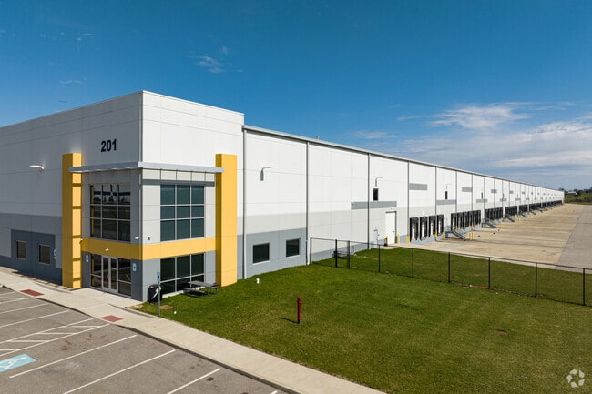
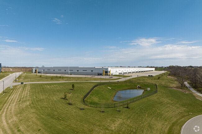
Property Record
201 Richard Knock Hwy, Walton, KY 41094

Current Lease Availabilities
NEARBY LISTINGS FOR SALE OR LEASE
Property Detail
201 Richard Knock Hwy
022-00-00-004.05
76.458 AC NES JONES RD APPROX 1800' SE OF MARY GRUBBS HWY
Realpropertynec
Kenton
X
Kentucky
21015C0325D
76.46 AC
2025
Florence/Richwood
2025
Cincinnati/Dayton
063701
Cincinnati, OH-KY-IN
DEMOGRAPHICS near 201 Richard Knock Hwy
1 Mile
3 Mile
5 Mile
2024 Total Population
1,448
9,222
22,270
2029 Population
1,545
9,794
23,456
Pop Growth 2024-2029
+ 6.70%
+ 6.20%
+ 5.33%
Average Age
37
36
38
2024 Total Households
566
3,250
7,920
HH Growth 2024-2029
+ 6.89%
+ 6.25%
+ 5.40%
Median Household Inc
$68,636
$79,672
$87,151
Avg Household Size
2.60
2.80
2.80
2024 Avg HH Vehicles
2.00
2.00
2.00
Median Home Value
$205,357
$227,826
$256,318
Median Year Built
1992
1996
1995
Nearby Places
Map Layers
Map Styles
 Street
 Aerial
- Restaurants
- Banks
- Shops
- Fitness
- Groceries
PUBLIC TRANSPORTATION
AIRPORT
Cincinnati/Northern Kentucky International
DRIVE
WALK
Distance
Cincinnati/Northern Kentucky International
28 min
16.3 mi
Freight Ports
Port of Toledo
DRIVE
WALK
Distance
Port of Toledo
270 min
228.3 mi
Nearby Properties
Address
Land Use
TOTAL SIZE
Lot Size
Zoning
Address
Land Use
TOTAL SIZE
Lot Size
Zoning
54.13 AC
Address
Land Use
TOTAL SIZE
Lot Size
Zoning
37.55 AC
Address
Land Use
TOTAL SIZE
Lot Size
Zoning
678,322 SF
41.56 AC
Address
Land Use
TOTAL SIZE
Lot Size
Zoning
50.98 AC
Address
Land Use
TOTAL SIZE
Lot Size
Zoning
16.73 AC
Address
Land Use
TOTAL SIZE
Lot Size
Zoning
112 SF
10.08 AC
Address
Land Use
TOTAL SIZE
Lot Size
Zoning
Address
Land Use
TOTAL SIZE
Lot Size
Zoning
16.80 AC
Address
Land Use
TOTAL SIZE
Lot Size
Zoning
5.57 AC
Address
Land Use
TOTAL SIZE
Lot Size
Zoning
234,400 SF
26.27 AC
Address
Land Use
TOTAL SIZE
Lot Size
Zoning
115,640 SF
4 AC
Address
Land Use
TOTAL SIZE
Lot Size
Zoning
48,440 SF
2 AC
Address
Land Use
TOTAL SIZE
Lot Size
Zoning
13,704 SF
18.04 AC
Address
Land Use
TOTAL SIZE
Lot Size
Zoning
13,416 SF
8.78 AC
Address
Land Use
TOTAL SIZE
Lot Size
Zoning
Address
Land Use
TOTAL SIZE
Lot Size
Zoning
67,973 SF
7.10 AC
Address
Land Use
TOTAL SIZE
Lot Size
Zoning
1,456 SF
17.76 AC
Address
Land Use
TOTAL SIZE
Lot Size
Zoning
Address
Land Use
TOTAL SIZE
Lot Size
Zoning
Address
Land Use
TOTAL SIZE
Lot Size
Zoning
8.24 AC
Address
Land Use
TOTAL SIZE
Lot Size
Zoning
4.51 AC
Address
Land Use
TOTAL SIZE
Lot Size
Zoning
2,155 SF
14.28 AC
Address
Land Use
TOTAL SIZE
Lot Size
Zoning
14.09 AC
Address
Land Use
TOTAL SIZE
Lot Size
Zoning
984 SF
55.85 AC
Address
Land Use
TOTAL SIZE
Lot Size
Zoning
80.65 AC
Address
Land Use
TOTAL SIZE
Lot Size
Zoning
24,000 SF
3.54 AC
Address
Land Use
TOTAL SIZE
Lot Size
Zoning
11.50 AC
Address
Land Use
TOTAL SIZE
Lot Size
Zoning
11.48 AC
Address
Land Use
TOTAL SIZE
Lot Size
Zoning
5.48 AC
The World's #1 Commercial Real Estate Marketplace
Connect with us
© 2026 CoStar Group
The information above has been obtained from sources believed reliable. While we do not doubt its accuracy we have not verified it and make no guarantee, warranty or representation about it. It is your responsibility to independently confirm its accuracy and completeness. Any projections, opinions, assumptions, or estimates used are for example only and do not represent the current or future performance of the property. The value of this transaction to you depends on tax and other factors which should be evaluated by your tax, financial, and legal advisors. You and your advisors should conduct a careful, independent investigation of the property to determine to your satisfaction the suitability of the property for your needs.