Property Record
201 River Pointe Dr, Conroe, TX 77304

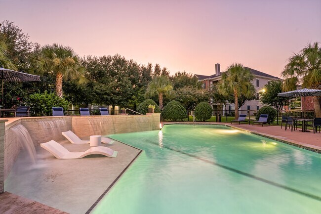
Property Detail
201 River Pointe Dr
Houston-Pasadena-The Woodlands, TX
S833100 - RIVER POINTE III APARTMENTS, BLOCK 1, RES A, ACRES 11.2445 - UDI: 48.750000%
8331-00-00101
Montgomery
Multifamilydwelling
Texas
B and X Area of moderate flood hazard, usually the area between the limits of the 100-year and 500-year floods.
11.25 AC
2024
Outlying Montgomery County
2025
Houston
693303
NEARBY LISTINGS FOR SALE OR LEASE
-
-
View all Conroe listings for sale on LoopNet.com
DEMOGRAPHICS near 201 River Pointe Dr
1 mile
3 mile
5 mile
2025 Total Population
9,283
51,237
121,534
2030 Population
10,968
60,483
143,096
Pop Growth 2025-2030
+ 18.15%
+ 18.05%
+ 17.74%
Average Age
36
37
37
2025 Total Households
3,636
18,468
44,214
HH Growth 2025-2030
+ 18.70%
+ 18.66%
+ 18.54%
Median Household Inc
$68,725
$73,366
$79,310
Avg Household Size
2.50
2.70
2.60
2025 Avg HH Vehicles
2.00
2.00
2.00
Median Home Value
$359,072
$297,535
$333,747
Median Year Built
2003
2000
2009
Nearby Places
Map Layers
Map Styles
 Street
 Aerial
Transit
 Traffic
 Biking
Places
Listings with unknown addresses are not visible on the map
- Restaurants
- Banks
- Shops
- Fitness
- Groceries
PUBLIC TRANSPORTATION
AIRPORT
George Bush Intcntl/Houston
Drive
Walk
Distance
George Bush Intcntl/Houston
36 min
29.4 mi
Freight Ports
Port of Houston
Drive
Walk
Distance
Port of Houston
59 min
45.2 mi
Nearby Properties
Address
Land Use
TOTAL SIZE
Lot Size
Zoning
Address
Land Use
TOTAL SIZE
Lot Size
Zoning
470,259 SF
27.98 AC
1
Address
Land Use
TOTAL SIZE
Lot Size
Zoning
353,247 SF
14.38 AC
Address
Land Use
TOTAL SIZE
Lot Size
Zoning
292,274 SF
7.55 AC
Address
Land Use
TOTAL SIZE
Lot Size
Zoning
354,000 SF
13.81 AC
Address
Land Use
TOTAL SIZE
Lot Size
Zoning
441,092 SF
29.09 AC
Address
Land Use
TOTAL SIZE
Lot Size
Zoning
304,482 SF
12.15 AC
Address
Land Use
TOTAL SIZE
Lot Size
Zoning
274,494 SF
28.96 AC
Address
Land Use
TOTAL SIZE
Lot Size
Zoning
262,925 SF
12.16 AC
Address
Land Use
TOTAL SIZE
Lot Size
Zoning
284,451 SF
13.66 AC
1
Address
Land Use
TOTAL SIZE
Lot Size
Zoning
326,478 SF
20.22 AC
Address
Land Use
TOTAL SIZE
Lot Size
Zoning
159,144 SF
32.27 AC
Address
Land Use
TOTAL SIZE
Lot Size
Zoning
168,926 SF
9.12 AC
Address
Land Use
TOTAL SIZE
Lot Size
Zoning
195,956 SF
1.76 AC
1
Address
Land Use
TOTAL SIZE
Lot Size
Zoning
276,238 SF
21.48 AC
Address
Land Use
TOTAL SIZE
Lot Size
Zoning
191,006 SF
9.19 AC
Address
Land Use
TOTAL SIZE
Lot Size
Zoning
142,800 SF
7.82 AC
Address
Land Use
TOTAL SIZE
Lot Size
Zoning
136,300 SF
9.08 AC
1
Address
Land Use
TOTAL SIZE
Lot Size
Zoning
89,298 SF
9.22 AC
Address
Land Use
TOTAL SIZE
Lot Size
Zoning
197,533 SF
58.31 AC
Address
Land Use
TOTAL SIZE
Lot Size
Zoning
100,800 SF
8.60 AC
Address
Land Use
TOTAL SIZE
Lot Size
Zoning
85,560 SF
8.55 AC
Address
Land Use
TOTAL SIZE
Lot Size
Zoning
175,476 SF
8.03 AC
1
Address
Land Use
TOTAL SIZE
Lot Size
Zoning
70,010 SF
8.89 AC
Address
Land Use
TOTAL SIZE
Lot Size
Zoning
99,660 SF
4.19 AC
Address
Land Use
TOTAL SIZE
Lot Size
Zoning
94,950 SF
7.41 AC
1
Address
Land Use
TOTAL SIZE
Lot Size
Zoning
148,906 SF
7.05 AC
1
Address
Land Use
TOTAL SIZE
Lot Size
Zoning
171,550 SF
25.36 AC
1
Address
Land Use
TOTAL SIZE
Lot Size
Zoning
89,736 SF
26.85 AC
1
Address
Land Use
TOTAL SIZE
Lot Size
Zoning
222,647 SF
11.25 AC
The World's #1 Commercial Real Estate Marketplace
Connect with us
© 2026 CoStar Group
The information above has been obtained from sources believed reliable. While we do not doubt its accuracy we have not verified it and make no guarantee, warranty or representation about it. It is your responsibility to independently confirm its accuracy and completeness. Any projections, opinions, assumptions, or estimates used are for example only and do not represent the current or future performance of the property. The value of this transaction to you depends on tax and other factors which should be evaluated by your tax, financial, and legal advisors. You and your advisors should conduct a careful, independent investigation of the property to determine to your satisfaction the suitability of the property for your needs.