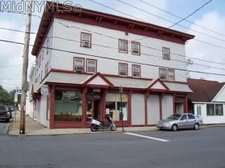
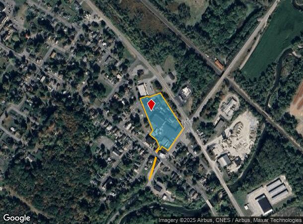
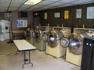
Property Record
201 River St, Oriskany, NY 13424
NEARBY LISTINGS FOR SALE OR LEASE
-
-
View all Oriskany listings for sale on LoopNet.com
Property Detail
201 River St
307001 276.018-2-30
Oneida
Manufacturinglight
New York
X
30.000
36065C0587F
4.40 AC
2025
Outlying Oneida County
2024
Utica/Rome
026100
Utica-Rome, NY
390,600 SF
DEMOGRAPHICS near 201 River St
1 Mile
3 Mile
5 Mile
2024 Total Population
1,410
9,745
32,592
2029 Population
1,357
9,573
32,009
Pop Growth 2024-2029
(3.76%)
(1.77%)
(1.79%)
Average Age
43
42
43
2024 Total Households
605
3,170
13,008
HH Growth 2024-2029
(3.97%)
(2.37%)
(2.06%)
Median Household Inc
$59,560
$74,979
$71,805
Avg Household Size
2.30
2.30
2.20
2024 Avg HH Vehicles
2.00
2.00
2.00
Median Home Value
$145,796
$176,109
$165,973
Median Year Built
1952
1957
1959
Nearby Places
- Restaurants
- Banks
- Shops
- Fitness
- Groceries
PUBLIC TRANSPORTATION
COMMUTER RAIL
Rome (Toronto - New York - VIA Rail)
DRIVE
WALK
Distance
Rome (Toronto - New York - VIA Rail)
11 min
6.8 mi
Rome Amtrak Station (Empire Service - Amtrak, Maple Leaf - Amtrak)
DRIVE
WALK
Distance
Rome Amtrak Station (Empire Service - Amtrak, Maple Leaf - Amtrak)
11 min
6.8 mi
Freight Ports
Albany, NY Port
DRIVE
WALK
Distance
Albany, NY Port
123 min
101.9 mi
Nearby Properties
Address
Land Use
TOTAL SIZE
Lot Size
Zoning
Address
Land Use
TOTAL SIZE
Lot Size
Zoning
Address
Land Use
TOTAL SIZE
Lot Size
Zoning
127.26 AC
Address
Land Use
TOTAL SIZE
Lot Size
Zoning
1 AC
Address
Land Use
TOTAL SIZE
Lot Size
Zoning
Address
Land Use
TOTAL SIZE
Lot Size
Zoning
3,995 SF
261.48 AC
Address
Land Use
TOTAL SIZE
Lot Size
Zoning
239,590 SF
22.10 AC
01 - NOT Z
Address
Land Use
TOTAL SIZE
Lot Size
Zoning
58,650 SF
1,024.59 AC
05 - COMME
Address
Land Use
TOTAL SIZE
Lot Size
Zoning
180,605 SF
40.60 AC
Address
Land Use
TOTAL SIZE
Lot Size
Zoning
26,085 SF
8.10 AC
01 - NOT Z
Address
Land Use
TOTAL SIZE
Lot Size
Zoning
151,310 SF
26.75 AC
01 - NOT Z
Address
Land Use
TOTAL SIZE
Lot Size
Zoning
116,536 SF
71.27 AC
01 - NOT Z
Address
Land Use
TOTAL SIZE
Lot Size
Zoning
54,952 SF
74.80 AC
01 - NOT Z
Address
Land Use
TOTAL SIZE
Lot Size
Zoning
62,840 SF
9.90 AC
01 - NOT Z
Address
Land Use
TOTAL SIZE
Lot Size
Zoning
91,688 SF
40.70 AC
01 - NOT Z
Address
Land Use
TOTAL SIZE
Lot Size
Zoning
58,703 SF
25.10 AC
01 - NOT Z
Address
Land Use
TOTAL SIZE
Lot Size
Zoning
150,000 SF
20.52 AC
05 - COMME
Address
Land Use
TOTAL SIZE
Lot Size
Zoning
264.20 AC
01 - NOT Z
Address
Land Use
TOTAL SIZE
Lot Size
Zoning
82,500 SF
47.32 AC
05 - COMME
Address
Land Use
TOTAL SIZE
Lot Size
Zoning
13,260 SF
6 AC
Address
Land Use
TOTAL SIZE
Lot Size
Zoning
27,068 SF
2.60 AC
01 - NOT Z
Address
Land Use
TOTAL SIZE
Lot Size
Zoning
103,600 SF
5.50 AC
05 - COMME
Address
Land Use
TOTAL SIZE
Lot Size
Zoning
22.40 AC
01 - NOT Z
Address
Land Use
TOTAL SIZE
Lot Size
Zoning
7,956 SF
05 - COMME
Address
Land Use
TOTAL SIZE
Lot Size
Zoning
37,240 SF
7.87 AC
01 - NOT Z
Address
Land Use
TOTAL SIZE
Lot Size
Zoning
51,395 SF
4.46 AC
05 - COMME
Address
Land Use
TOTAL SIZE
Lot Size
Zoning
14,134 SF
4.74 AC
05 - COMME
Address
Land Use
TOTAL SIZE
Lot Size
Zoning
23,140 SF
5.74 AC
01 - NOT Z
Address
Land Use
TOTAL SIZE
Lot Size
Zoning
14,314 SF
12.20 AC
Address
Land Use
TOTAL SIZE
Lot Size
Zoning
8,280 SF
7.65 AC
Address
Land Use
TOTAL SIZE
Lot Size
Zoning
11,530 SF
1.10 AC
01 - NOT Z
The World's #1 Commercial Real Estate Marketplace
Connect with us
© 2025 CoStar Group
The information above has been obtained from sources believed reliable. While we do not doubt its accuracy we have not verified it and make no guarantee, warranty or representation about it. It is your responsibility to independently confirm its accuracy and completeness. Any projections, opinions, assumptions, or estimates used are for example only and do not represent the current or future performance of the property. The value of this transaction to you depends on tax and other factors which should be evaluated by your tax, financial, and legal advisors. You and your advisors should conduct a careful, independent investigation of the property to determine to your satisfaction the suitability of the property for your needs.