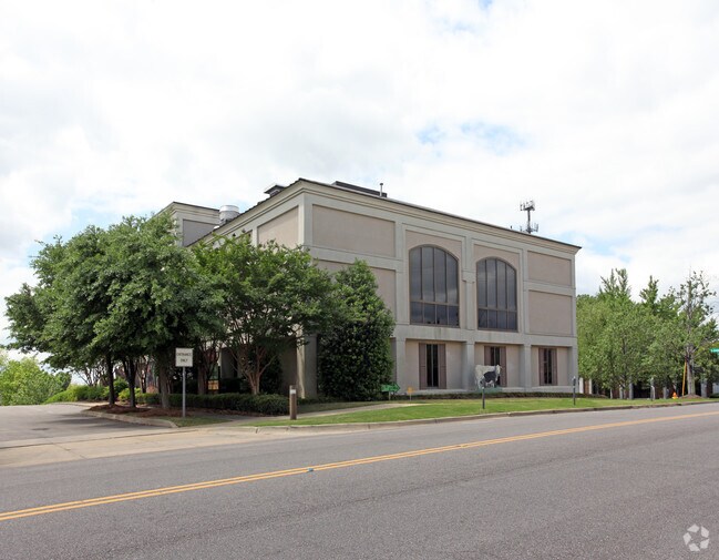
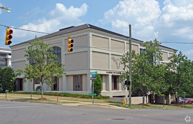
Property Record
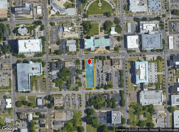
201 S Bainbridge St, Montgomery, AL 36104
NEARBY LISTINGS FOR SALE OR LEASE
Property Detail
201 S Bainbridge St
10-03-07-3-010-003.000
BEG SE COR BAINBRIDGE ST & ADAMS AVE IN SW1/4 SEC 7 T16N R18E TH E 100 TH S 320 TH W 98 TH N 320 TO POB 1003073010003000
Officebuilding
Montgomery
X
Alabama
01101C0093J
0.74 AC
2025
Downtown Montgomery
2025
Montgomery
000200
Montgomery, AL
18,094 SF
DEMOGRAPHICS near 201 S Bainbridge St
1 Mile
3 Mile
5 Mile
2024 Total Population
8,633
60,628
111,815
2029 Population
8,739
60,809
110,697
Pop Growth 2024-2029
+ 1.23%
+ 0.30%
(1.00%)
Average Age
35
38
39
2024 Total Households
2,941
24,475
45,600
HH Growth 2024-2029
+ 2.82%
+ 0.53%
(0.98%)
Median Household Inc
$28,828
$34,754
$39,744
Avg Household Size
1.90
2.20
2.30
2024 Avg HH Vehicles
1.00
1.00
2.00
Median Home Value
$92,968
$96,950
$115,483
Median Year Built
1961
1958
1967
Nearby Places
Map Layers
Map Styles
 Street
 Aerial
- Restaurants
- Banks
- Shops
- Fitness
- Groceries
PUBLIC TRANSPORTATION
AIRPORT
Montgomery Regional (Dannelly Field)
DRIVE
WALK
Distance
Montgomery Regional (Dannelly Field)
14 min
9.5 mi
Freight Ports
Port of Mobile
DRIVE
WALK
Distance
Port of Mobile
184 min
168.5 mi
Nearby Properties
Address
Land Use
TOTAL SIZE
Lot Size
Zoning
Address
Land Use
TOTAL SIZE
Lot Size
Zoning
800,140 SF
2.27 AC
T5
Address
Land Use
TOTAL SIZE
Lot Size
Zoning
392,741 SF
2.98 AC
T5
Address
Land Use
TOTAL SIZE
Lot Size
Zoning
150,842 SF
5.40 AC
T5
Address
Land Use
TOTAL SIZE
Lot Size
Zoning
193,643 SF
1.61 AC
T5
Address
Land Use
TOTAL SIZE
Lot Size
Zoning
36,543 SF
0.62 AC
SD-M
Address
Land Use
TOTAL SIZE
Lot Size
Zoning
40,829 SF
50.49 AC
SD
Address
Land Use
TOTAL SIZE
Lot Size
Zoning
10,844 SF
1.63 AC
Address
Land Use
TOTAL SIZE
Lot Size
Zoning
285,162 SF
M-1
Address
Land Use
TOTAL SIZE
Lot Size
Zoning
107,355 SF
4.12 AC
T5
Address
Land Use
TOTAL SIZE
Lot Size
Zoning
216,654 SF
26.49 AC
B-2
Address
Land Use
TOTAL SIZE
Lot Size
Zoning
93,981 SF
1.90 AC
T5
Address
Land Use
TOTAL SIZE
Lot Size
Zoning
13,273 SF
2.05 AC
T5
Address
Land Use
TOTAL SIZE
Lot Size
Zoning
8,519 SF
15.60 AC
B-2
Address
Land Use
TOTAL SIZE
Lot Size
Zoning
58,930 SF
2.24 AC
T5
Address
Land Use
TOTAL SIZE
Lot Size
Zoning
91,378 SF
2.46 AC
SD-M
Address
Land Use
TOTAL SIZE
Lot Size
Zoning
117,175 SF
1.49 AC
T5
Address
Land Use
TOTAL SIZE
Lot Size
Zoning
113,449 SF
0.80 AC
T5
Address
Land Use
TOTAL SIZE
Lot Size
Zoning
77,905 SF
0.83 AC
T5
Address
Land Use
TOTAL SIZE
Lot Size
Zoning
38,226 SF
5.77 AC
T5
Address
Land Use
TOTAL SIZE
Lot Size
Zoning
120,509 SF
0.29 AC
T5
Address
Land Use
TOTAL SIZE
Lot Size
Zoning
1.72 AC
T5
Address
Land Use
TOTAL SIZE
Lot Size
Zoning
22,183 SF
8.38 AC
T5
Address
Land Use
TOTAL SIZE
Lot Size
Zoning
116,707 SF
0.28 AC
T5
Address
Land Use
TOTAL SIZE
Lot Size
Zoning
96,168 SF
95.16 AC
INST
Address
Land Use
TOTAL SIZE
Lot Size
Zoning
1,721 SF
12.02 AC
R-60-M
Address
Land Use
TOTAL SIZE
Lot Size
Zoning
81,736 SF
0.63 AC
T5
Address
Land Use
TOTAL SIZE
Lot Size
Zoning
3,401 SF
3.21 AC
T5
Address
Land Use
TOTAL SIZE
Lot Size
Zoning
128,328 SF
2.27 AC
T5
Address
Land Use
TOTAL SIZE
Lot Size
Zoning
30,386 SF
10.12 AC
B-2
Address
Land Use
TOTAL SIZE
Lot Size
Zoning
144,788 SF
0.33 AC
T5
The World's #1 Commercial Real Estate Marketplace
Connect with us
© 2025 CoStar Group
The information above has been obtained from sources believed reliable. While we do not doubt its accuracy we have not verified it and make no guarantee, warranty or representation about it. It is your responsibility to independently confirm its accuracy and completeness. Any projections, opinions, assumptions, or estimates used are for example only and do not represent the current or future performance of the property. The value of this transaction to you depends on tax and other factors which should be evaluated by your tax, financial, and legal advisors. You and your advisors should conduct a careful, independent investigation of the property to determine to your satisfaction the suitability of the property for your needs.