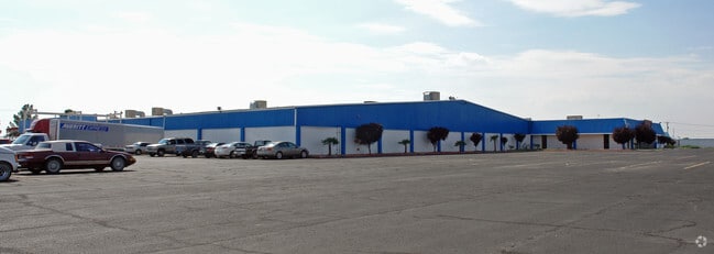
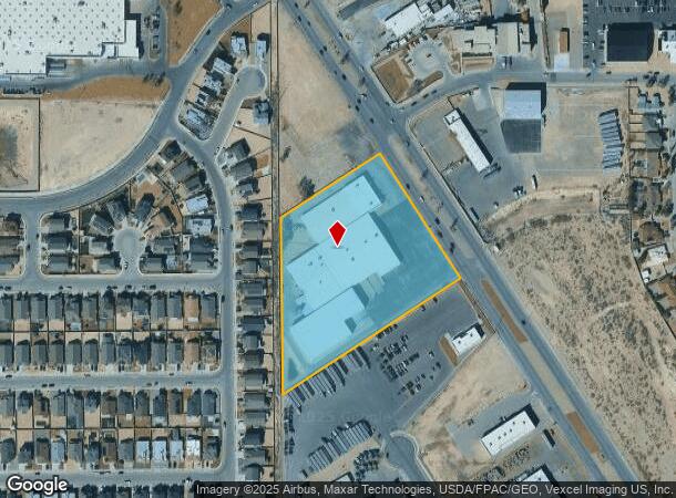
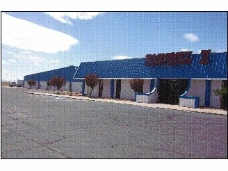
Property Record
201 S Darrington Rd, El Paso, TX 79928
NEARBY LISTINGS FOR SALE OR LEASE
Property Detail
201 S Darrington Rd
El Paso
Horizon Industrial Park
El Paso, TX
BLK 1 HORIZON INDUSTRIAL PARK #1 REPLAT A LOT 2
H789-000-001A-0200
El Paso
Commercialnec
Texas
2024
2
2025
5.14 AC
010357
Horizon
92,580 SF
DEMOGRAPHICS near 201 S Darrington Rd
1 Mile
3 Mile
5 Mile
2024 Total Population
8,088
56,426
89,800
2029 Population
8,117
57,718
92,154
Pop Growth 2024-2029
+ 0.36%
+ 2.29%
+ 2.62%
Average Age
34
32
32
2024 Total Households
2,325
16,108
25,984
HH Growth 2024-2029
+ 0.34%
+ 2.40%
+ 2.71%
Median Household Inc
$58,713
$61,472
$59,897
Avg Household Size
3.50
3.50
3.40
2024 Avg HH Vehicles
2.00
2.00
2.00
Median Home Value
$145,782
$153,967
$156,537
Median Year Built
2000
2006
2007
Nearby Places
Map Layers
Map Styles
 Street
 Aerial
- Restaurants
- Banks
- Shops
- Fitness
- Groceries
PUBLIC TRANSPORTATION
AIRPORT
El Paso International
DRIVE
WALK
Distance
El Paso International
30 min
20.1 mi
Freight Ports
Port of Corpus Christi
DRIVE
WALK
Distance
Port of Corpus Christi
1 min
592.1 mi
SALE & LEASE HISTORY
LISTING DATE
SALE/LEASE

Aug 31, 2017
For Lease
Nearby Properties
Address
Land Use
TOTAL SIZE
Lot Size
Zoning
Address
Land Use
TOTAL SIZE
Lot Size
Zoning
229,764 SF
55.43 AC
Address
Land Use
TOTAL SIZE
Lot Size
Zoning
296,914 SF
15.02 AC
Address
Land Use
TOTAL SIZE
Lot Size
Zoning
196,368 SF
20.10 AC
C2
Address
Land Use
TOTAL SIZE
Lot Size
Zoning
149,819 SF
31.65 AC
R2
Address
Land Use
TOTAL SIZE
Lot Size
Zoning
157,899 SF
41.45 AC
HR9
Address
Land Use
TOTAL SIZE
Lot Size
Zoning
125,804 SF
24.92 AC
Address
Land Use
TOTAL SIZE
Lot Size
Zoning
120,146 SF
11.02 AC
R9
Address
Land Use
TOTAL SIZE
Lot Size
Zoning
130,951 SF
19.02 AC
R2
Address
Land Use
TOTAL SIZE
Lot Size
Zoning
214,346 SF
11.20 AC
Address
Land Use
TOTAL SIZE
Lot Size
Zoning
214,346 SF
11.49 AC
Address
Land Use
TOTAL SIZE
Lot Size
Zoning
214,346 SF
11.43 AC
Address
Land Use
TOTAL SIZE
Lot Size
Zoning
214,346 SF
11.90 AC
Address
Land Use
TOTAL SIZE
Lot Size
Zoning
85,650 SF
16 AC
R9
Address
Land Use
TOTAL SIZE
Lot Size
Zoning
40,954 SF
7.76 AC
C2
Address
Land Use
TOTAL SIZE
Lot Size
Zoning
152,833 SF
9.75 AC
Address
Land Use
TOTAL SIZE
Lot Size
Zoning
156,914 SF
10.37 AC
Address
Land Use
TOTAL SIZE
Lot Size
Zoning
415.01 AC
C2
Address
Land Use
TOTAL SIZE
Lot Size
Zoning
63,188 SF
6.45 AC
Address
Land Use
TOTAL SIZE
Lot Size
Zoning
200,340 SF
4.25 AC
Address
Land Use
TOTAL SIZE
Lot Size
Zoning
789.83 AC
A2
Address
Land Use
TOTAL SIZE
Lot Size
Zoning
163,307 SF
5.93 AC
M1
Address
Land Use
TOTAL SIZE
Lot Size
Zoning
21,405 SF
18.28 AC
HR2
Address
Land Use
TOTAL SIZE
Lot Size
Zoning
19,227 SF
24.06 AC
Address
Land Use
TOTAL SIZE
Lot Size
Zoning
47,941 SF
6.25 AC
Address
Land Use
TOTAL SIZE
Lot Size
Zoning
41,612 SF
7.79 AC
Address
Land Use
TOTAL SIZE
Lot Size
Zoning
66,920 SF
5.55 AC
C2
Address
Land Use
TOTAL SIZE
Lot Size
Zoning
21,993 SF
0.54 AC
C1
Address
Land Use
TOTAL SIZE
Lot Size
Zoning
32,666 SF
17.96 AC
HR2
Address
Land Use
TOTAL SIZE
Lot Size
Zoning
85,718 SF
20 AC
Address
Land Use
TOTAL SIZE
Lot Size
Zoning
49,037 SF
24.91 AC
C2
The World's #1 Commercial Real Estate Marketplace
Connect with us
© 2026 CoStar Group
The information above has been obtained from sources believed reliable. While we do not doubt its accuracy we have not verified it and make no guarantee, warranty or representation about it. It is your responsibility to independently confirm its accuracy and completeness. Any projections, opinions, assumptions, or estimates used are for example only and do not represent the current or future performance of the property. The value of this transaction to you depends on tax and other factors which should be evaluated by your tax, financial, and legal advisors. You and your advisors should conduct a careful, independent investigation of the property to determine to your satisfaction the suitability of the property for your needs.