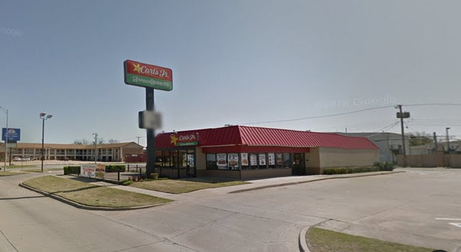
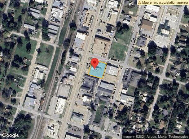
Property Record
201 S Mill St, Pryor, OK 74361

NEARBY LISTINGS FOR SALE OR LEASE
-
-
View all Pryor listings for sale on LoopNet.com
Property Detail
201 S Mill St
1001-00-062-002-0-001-00
Pryor Original
Restaurantdrivein
PRYOR ORIG BLK 62 LOTS 2 & 3 (CARL'S JR #1673)
X
Mayes
40097C0237E
Oklahoma
2025
2,3
2025
0.55 AC
040100
Other Market Areas
3,345 SF
DEMOGRAPHICS near 201 S Mill St
1 Mile
3 Mile
5 Mile
2024 Total Population
5,651
11,850
14,057
2029 Population
5,926
12,299
14,579
Pop Growth 2024-2029
+ 4.87%
+ 3.79%
+ 3.71%
Average Age
38
38
39
2024 Total Households
2,198
4,617
5,439
HH Growth 2024-2029
+ 4.91%
+ 3.81%
+ 3.73%
Median Household Inc
$38,960
$45,086
$50,241
Avg Household Size
2.50
2.50
2.50
2024 Avg HH Vehicles
2.00
2.00
2.00
Median Home Value
$109,697
$152,171
$165,447
Median Year Built
1970
1975
1977
Nearby Places
Map Layers
Map Styles
 Street
 Aerial
- Restaurants
- Banks
- Shops
- Fitness
- Groceries
PUBLIC TRANSPORTATION
AIRPORT
Tulsa International
DRIVE
WALK
Distance
Tulsa International
49 min
37.2 mi
Freight Ports
DRIVE
WALK
Distance
34 min
25.2 mi
SALE & LEASE HISTORY
LISTING DATE
SALE/LEASE

Aug 05, 2019
For Sale
Nearby Properties
Address
Land Use
TOTAL SIZE
Lot Size
Zoning
Address
Land Use
TOTAL SIZE
Lot Size
Zoning
4,926 SF
10 AC
Address
Land Use
TOTAL SIZE
Lot Size
Zoning
181,766 SF
19.29 AC
Address
Land Use
TOTAL SIZE
Lot Size
Zoning
11,790 SF
9 AC
Address
Land Use
TOTAL SIZE
Lot Size
Zoning
28,440 SF
11.50 AC
Address
Land Use
TOTAL SIZE
Lot Size
Zoning
24,470 SF
2.09 AC
Address
Land Use
TOTAL SIZE
Lot Size
Zoning
8,242 SF
8.28 AC
Address
Land Use
TOTAL SIZE
Lot Size
Zoning
8,550 SF
0.34 AC
Address
Land Use
TOTAL SIZE
Lot Size
Zoning
89,982 SF
7.43 AC
Address
Land Use
TOTAL SIZE
Lot Size
Zoning
46,665 SF
10 AC
Address
Land Use
TOTAL SIZE
Lot Size
Zoning
11,232 SF
0.40 AC
Address
Land Use
TOTAL SIZE
Lot Size
Zoning
8,400 SF
0.45 AC
Address
Land Use
TOTAL SIZE
Lot Size
Zoning
3,910 SF
3.89 AC
Address
Land Use
TOTAL SIZE
Lot Size
Zoning
5,562 SF
0.44 AC
Address
Land Use
TOTAL SIZE
Lot Size
Zoning
10,442 SF
0.34 AC
Address
Land Use
TOTAL SIZE
Lot Size
Zoning
7,800 SF
0.98 AC
Address
Land Use
TOTAL SIZE
Lot Size
Zoning
3,264 SF
2.86 AC
Address
Land Use
TOTAL SIZE
Lot Size
Zoning
1,060 SF
7.42 AC
Address
Land Use
TOTAL SIZE
Lot Size
Zoning
5,000 SF
0.68 AC
Address
Land Use
TOTAL SIZE
Lot Size
Zoning
81,116 SF
6.53 AC
Address
Land Use
TOTAL SIZE
Lot Size
Zoning
11,704 SF
0.34 AC
Address
Land Use
TOTAL SIZE
Lot Size
Zoning
2,880 SF
5.84 AC
Address
Land Use
TOTAL SIZE
Lot Size
Zoning
2,194 SF
0.77 AC
Address
Land Use
TOTAL SIZE
Lot Size
Zoning
5,686 SF
1.84 AC
Address
Land Use
TOTAL SIZE
Lot Size
Zoning
4,500 SF
0.60 AC
Address
Land Use
TOTAL SIZE
Lot Size
Zoning
14,636 SF
2.09 AC
The World's #1 Commercial Real Estate Marketplace
Connect with us
© 2026 CoStar Group
The information above has been obtained from sources believed reliable. While we do not doubt its accuracy we have not verified it and make no guarantee, warranty or representation about it. It is your responsibility to independently confirm its accuracy and completeness. Any projections, opinions, assumptions, or estimates used are for example only and do not represent the current or future performance of the property. The value of this transaction to you depends on tax and other factors which should be evaluated by your tax, financial, and legal advisors. You and your advisors should conduct a careful, independent investigation of the property to determine to your satisfaction the suitability of the property for your needs.