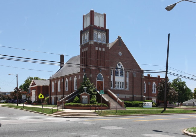
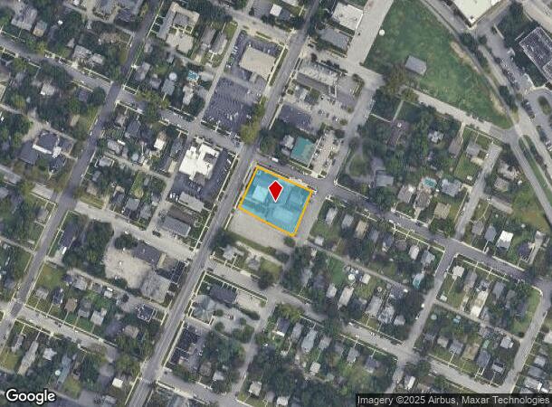
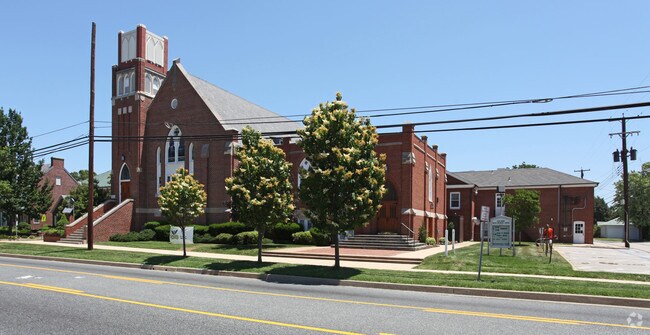
Property Record
201 Se Crain Hwy N, Glen Burnie, MD 21061
NEARBY LISTINGS FOR SALE OR LEASE
-
-
View all Glen Burnie listings for sale on LoopNet.com
Property Detail
201 Se Crain Hwy N
Baltimore-Columbia-Towson, MD
Glen Burnie
05-326-02787611
LTS 1 2 BK 47 GLEN BURNIE
Commercialacreage
Anne Arundel
X
Maryland
24003C0042E
1
2024
0.69 AC
2025
Route 2 Corridor North
730401
Baltimore
33,346 SF
DEMOGRAPHICS near 201 Se Crain Hwy N
1 Mile
3 Mile
5 Mile
2024 Total Population
13,615
91,301
190,643
2029 Population
13,887
93,226
194,835
Pop Growth 2024-2029
+ 2.00%
+ 2.11%
+ 2.20%
Average Age
40
39
39
2024 Total Households
5,027
35,067
70,710
HH Growth 2024-2029
+ 2.01%
+ 2.14%
+ 2.28%
Median Household Inc
$80,615
$80,115
$93,934
Avg Household Size
2.60
2.50
2.60
2024 Avg HH Vehicles
2.00
2.00
2.00
Median Home Value
$278,759
$307,754
$343,799
Median Year Built
1956
1973
1977
Nearby Places
Map Layers
Map Styles
 Street
 Aerial
- Restaurants
- Banks
- Shops
- Fitness
- Groceries
PUBLIC TRANSPORTATION
TRANSIT/SUBWAY
Cromwell Station/Glen Burnie (Timonium & Cromwell - Maryland Transit Administration Light Rail (Baltimore Light Rail))
DRIVE
WALK
Distance
Cromwell Station/Glen Burnie (Timonium & Cromwell - Maryland Transit Administration Light Rail (Baltimore Light Rail))
3 min
18 min
0.9 mi
COMMUTER RAIL
Bwi Airport (Penn Line - Maryland Area Regional Commuter Trains (The MARC))
DRIVE
WALK
Distance
Bwi Airport (Penn Line - Maryland Area Regional Commuter Trains (The MARC))
13 min
6.1 mi
St Denis (Camden Line - Maryland Area Regional Commuter Trains (The MARC))
DRIVE
WALK
Distance
St Denis (Camden Line - Maryland Area Regional Commuter Trains (The MARC))
16 min
8.4 mi
AIRPORT
Baltimore/Washington International Thurgood Marshall
DRIVE
WALK
Distance
Baltimore/Washington International Thurgood Marshall
12 min
5.7 mi
Freight Ports
Port of Baltimore
DRIVE
WALK
Distance
Port of Baltimore
20 min
11.0 mi
Nearby Properties
Address
Land Use
TOTAL SIZE
Lot Size
Zoning
Address
Land Use
TOTAL SIZE
Lot Size
Zoning
637,060 SF
22.19 AC
C2
Address
Land Use
TOTAL SIZE
Lot Size
Zoning
851,355 SF
172.49 AC
R5
Address
Land Use
TOTAL SIZE
Lot Size
Zoning
374,664 SF
22.89 AC
R15
Address
Land Use
TOTAL SIZE
Lot Size
Zoning
356,600 SF
21.37 AC
R5
Address
Land Use
TOTAL SIZE
Lot Size
Zoning
32.18 AC
R15
Address
Land Use
TOTAL SIZE
Lot Size
Zoning
176,405 SF
41.81 AC
C3
Address
Land Use
TOTAL SIZE
Lot Size
Zoning
383,697 SF
68.35 AC
R5
Address
Land Use
TOTAL SIZE
Lot Size
Zoning
60,200 SF
778.66 AC
R1
Address
Land Use
TOTAL SIZE
Lot Size
Zoning
11.57 AC
R22
Address
Land Use
TOTAL SIZE
Lot Size
Zoning
778.66 AC
R1
Address
Land Use
TOTAL SIZE
Lot Size
Zoning
289,829 SF
24.56 AC
C3
Address
Land Use
TOTAL SIZE
Lot Size
Zoning
28.02 AC
R15
Address
Land Use
TOTAL SIZE
Lot Size
Zoning
19.20 AC
R15
Address
Land Use
TOTAL SIZE
Lot Size
Zoning
14.21 AC
R15
Address
Land Use
TOTAL SIZE
Lot Size
Zoning
1,555.10 AC
R1
Address
Land Use
TOTAL SIZE
Lot Size
Zoning
15.33 AC
R15
Address
Land Use
TOTAL SIZE
Lot Size
Zoning
12.90 AC
R15
Address
Land Use
TOTAL SIZE
Lot Size
Zoning
233,408 SF
24.73 AC
C3
Address
Land Use
TOTAL SIZE
Lot Size
Zoning
21.45 AC
R15
Address
Land Use
TOTAL SIZE
Lot Size
Zoning
14.53 AC
R22
Address
Land Use
TOTAL SIZE
Lot Size
Zoning
14.58 AC
R22
Address
Land Use
TOTAL SIZE
Lot Size
Zoning
16.72 AC
R15
Address
Land Use
TOTAL SIZE
Lot Size
Zoning
7.07 AC
R15
Address
Land Use
TOTAL SIZE
Lot Size
Zoning
5.95 AC
R22
Address
Land Use
TOTAL SIZE
Lot Size
Zoning
277,203 SF
15.88 AC
R15
Address
Land Use
TOTAL SIZE
Lot Size
Zoning
9.45 AC
R22
Address
Land Use
TOTAL SIZE
Lot Size
Zoning
16.26 AC
R15
Address
Land Use
TOTAL SIZE
Lot Size
Zoning
12 AC
C3
Address
Land Use
TOTAL SIZE
Lot Size
Zoning
119,220 SF
6.99 AC
W1
Address
Land Use
TOTAL SIZE
Lot Size
Zoning
10.92 AC
R15
The World's #1 Commercial Real Estate Marketplace
Connect with us
© 2025 CoStar Group
The information above has been obtained from sources believed reliable. While we do not doubt its accuracy we have not verified it and make no guarantee, warranty or representation about it. It is your responsibility to independently confirm its accuracy and completeness. Any projections, opinions, assumptions, or estimates used are for example only and do not represent the current or future performance of the property. The value of this transaction to you depends on tax and other factors which should be evaluated by your tax, financial, and legal advisors. You and your advisors should conduct a careful, independent investigation of the property to determine to your satisfaction the suitability of the property for your needs.