Property Record
201 Shady Ln, Macomb, IL 61455
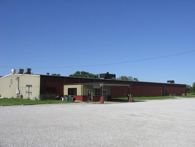

Property Detail
201 Shady Ln
Macomb, IL
SKATELAND ADD
11-401-215-00
McDonough
Skatingrink
Illinois
2025
2.10 AC
2024
Illinois North Area
010900
Other Market Areas
16,000 SF
NEARBY LISTINGS FOR SALE OR LEASE
DEMOGRAPHICS near 201 Shady Ln
1 mile
3 mile
5 mile
2025 Total Population
5,096
16,667
17,409
2030 Population
5,136
16,634
17,365
Pop Growth 2025-2030
+ 0.78%
(0.20%)
(0.25%)
Average Age
34
38
38
2025 Total Households
2,029
6,897
7,215
HH Growth 2025-2030
+ 0.84%
(0.36%)
(0.42%)
Median Household Inc
$36,753
$43,702
$44,607
Avg Household Size
2.00
2.00
2.00
2025 Avg HH Vehicles
2.00
2.00
2.00
Median Home Value
$96,706
$116,485
$119,751
Median Year Built
1978
1973
1973
Nearby Places
Map Layers
Map Styles
 Street
 Aerial
Layers
 Traffic
 Biking
Places
Listings with unknown addresses are not visible on the map
- Restaurants
- Banks
- Shops
- Fitness
- Groceries
PUBLIC TRANSPORTATION
COMMUTER RAIL
Drive
Walk
Distance
4 min
1.7 mi
SALE & LEASE HISTORY
LISTING DATE
SALE/LEASE

Jun 16, 2017
For Sale
Nearby Properties
Address
Land Use
TOTAL SIZE
Lot Size
Zoning
Address
Land Use
TOTAL SIZE
Lot Size
Zoning
Address
Land Use
TOTAL SIZE
Lot Size
Zoning
31.18 AC
Address
Land Use
TOTAL SIZE
Lot Size
Zoning
38,024 SF
5.35 AC
Address
Land Use
TOTAL SIZE
Lot Size
Zoning
55,785 SF
9.87 AC
Address
Land Use
TOTAL SIZE
Lot Size
Zoning
10,800 SF
3.85 AC
Address
Land Use
TOTAL SIZE
Lot Size
Zoning
91,908 SF
19.46 AC
Address
Land Use
TOTAL SIZE
Lot Size
Zoning
4.05 AC
Address
Land Use
TOTAL SIZE
Lot Size
Zoning
83,040 SF
1.01 AC
Address
Land Use
TOTAL SIZE
Lot Size
Zoning
7.65 AC
Address
Land Use
TOTAL SIZE
Lot Size
Zoning
1.59 AC
Address
Land Use
TOTAL SIZE
Lot Size
Zoning
27,160 SF
6.57 AC
Address
Land Use
TOTAL SIZE
Lot Size
Zoning
13,452 SF
Address
Land Use
TOTAL SIZE
Lot Size
Zoning
3,000 SF
6.36 AC
Address
Land Use
TOTAL SIZE
Lot Size
Zoning
48,025 SF
6.50 AC
Address
Land Use
TOTAL SIZE
Lot Size
Zoning
10,000 SF
0.61 AC
Address
Land Use
TOTAL SIZE
Lot Size
Zoning
31,835 SF
5.37 AC
Address
Land Use
TOTAL SIZE
Lot Size
Zoning
10,944 SF
3.52 AC
Address
Land Use
TOTAL SIZE
Lot Size
Zoning
37,547 SF
0.30 AC
Address
Land Use
TOTAL SIZE
Lot Size
Zoning
38,200 SF
0.56 AC
Address
Land Use
TOTAL SIZE
Lot Size
Zoning
56,152 SF
6.69 AC
Address
Land Use
TOTAL SIZE
Lot Size
Zoning
15,256 SF
1.97 AC
Address
Land Use
TOTAL SIZE
Lot Size
Zoning
14,084 SF
1.56 AC
Address
Land Use
TOTAL SIZE
Lot Size
Zoning
8,136 SF
3.60 AC
Address
Land Use
TOTAL SIZE
Lot Size
Zoning
9,840 SF
20.50 AC
Address
Land Use
TOTAL SIZE
Lot Size
Zoning
27,946 SF
1.54 AC
Address
Land Use
TOTAL SIZE
Lot Size
Zoning
13,450 SF
1.29 AC
Address
Land Use
TOTAL SIZE
Lot Size
Zoning
13,413 SF
3.50 AC
Address
Land Use
TOTAL SIZE
Lot Size
Zoning
16,700 SF
2.89 AC
The World's #1 Commercial Real Estate Marketplace
Connect with us
© 2026 CoStar Group
The information above has been obtained from sources believed reliable. While we do not doubt its accuracy we have not verified it and make no guarantee, warranty or representation about it. It is your responsibility to independently confirm its accuracy and completeness. Any projections, opinions, assumptions, or estimates used are for example only and do not represent the current or future performance of the property. The value of this transaction to you depends on tax and other factors which should be evaluated by your tax, financial, and legal advisors. You and your advisors should conduct a careful, independent investigation of the property to determine to your satisfaction the suitability of the property for your needs.