Property Record
201 Shore Dr, Bremerton, WA 98310


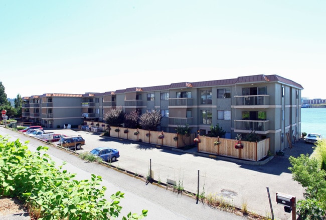
Property Detail
201 Shore Dr
3913-009-006-00-05
LOTS 6, 7, 8 AND 9, IN BLOCK 9, AND LOT 1, IN BLOCK 10, EXCEPT THE SOUTHEASTERLY 5 FEET THEREOF, OF TOWN OF DECATUR; AS PER PLAT RECORDED IN VOLUME 1 OF PLATS, PAGE 78, RECORDS OF KITSAP COUNTY AUDITOR; ALSO THAT PORTION OF VACATED TUNBRIDGE AVENUE N
Multifamilydwelling
Kitsap
NB
Washington
AE The base floodplain where base flood elevations are provided. AE Zones are now used on new format FIRMs instead of A1-A30 Zones.
1,6-8
2026
0.87 AC
2026
Manette
080400
Bremerton/Silverdale
45,904 SF
Bremerton-Silverdale-Port Orchard, WA
NEARBY LISTINGS FOR SALE OR LEASE
DEMOGRAPHICS near 201 Shore Dr
1 mile
3 mile
5 mile
2025 Total Population
9,331
62,103
126,532
2030 Population
9,538
63,650
129,828
Pop Growth 2025-2030
+ 2.22%
+ 2.49%
+ 2.60%
Average Age
40
40
40
2025 Total Households
4,202
24,126
48,654
HH Growth 2025-2030
+ 2.43%
+ 2.75%
+ 2.83%
Median Household Inc
$72,176
$76,987
$85,810
Avg Household Size
2.00
2.30
2.40
2025 Avg HH Vehicles
2.00
2.00
2.00
Median Home Value
$478,120
$447,966
$472,443
Median Year Built
1952
1970
1979
Nearby Places
Map Layers
Map Styles
 Street
 Aerial
Layers
 Traffic
 Biking
Places
Listings with unknown addresses are not visible on the map
- Restaurants
- Banks
- Shops
- Fitness
- Groceries
PUBLIC TRANSPORTATION
AIRPORT
Seattle Paine Field International
Drive
Walk
Distance
Seattle Paine Field International
103 min
41.3 mi
Freight Ports
Port of Seattle
Drive
Walk
Distance
Port of Seattle
76 min
20.5 mi
Nearby Properties
Address
Land Use
TOTAL SIZE
Lot Size
Zoning
Address
Land Use
TOTAL SIZE
Lot Size
Zoning
21,408 SF
8.26 AC
BVSAP
Address
Land Use
TOTAL SIZE
Lot Size
Zoning
134,724 SF
6.85 AC
GC
Address
Land Use
TOTAL SIZE
Lot Size
Zoning
151,599 SF
5.44 AC
R-40
Address
Land Use
TOTAL SIZE
Lot Size
Zoning
214,450 SF
21.68 AC
R-40
Address
Land Use
TOTAL SIZE
Lot Size
Zoning
192,475 SF
16.26 AC
C
Address
Land Use
TOTAL SIZE
Lot Size
Zoning
0.54 AC
CITY
Address
Land Use
TOTAL SIZE
Lot Size
Zoning
Address
Land Use
TOTAL SIZE
Lot Size
Zoning
80,228 SF
7.03 AC
GC
Address
Land Use
TOTAL SIZE
Lot Size
Zoning
1,344 SF
5.47 AC
R-40
Address
Land Use
TOTAL SIZE
Lot Size
Zoning
79,615 SF
1.25 AC
DSAP
Address
Land Use
TOTAL SIZE
Lot Size
Zoning
75,390 SF
4.46 AC
R-18
Address
Land Use
TOTAL SIZE
Lot Size
Zoning
77,580 SF
8.62 AC
UM
Address
Land Use
TOTAL SIZE
Lot Size
Zoning
122,799 SF
4.48 AC
R-40
Address
Land Use
TOTAL SIZE
Lot Size
Zoning
63,213 SF
4.15 AC
R-10
Address
Land Use
TOTAL SIZE
Lot Size
Zoning
58,376 SF
6.68 AC
R-18
Address
Land Use
TOTAL SIZE
Lot Size
Zoning
64,584 SF
4.92 AC
R-40
Address
Land Use
TOTAL SIZE
Lot Size
Zoning
49,604 SF
5.49 AC
UM
Address
Land Use
TOTAL SIZE
Lot Size
Zoning
68,079 SF
2.16 AC
BVSAP
Address
Land Use
TOTAL SIZE
Lot Size
Zoning
62,642 SF
4.91 AC
UM
Address
Land Use
TOTAL SIZE
Lot Size
Zoning
60,518 SF
2.62 AC
R-18
Address
Land Use
TOTAL SIZE
Lot Size
Zoning
56,006 SF
4.72 AC
UM
Address
Land Use
TOTAL SIZE
Lot Size
Zoning
55,412 SF
1.74 AC
R-18
Address
Land Use
TOTAL SIZE
Lot Size
Zoning
57,900 SF
3.90 AC
UH
Address
Land Use
TOTAL SIZE
Lot Size
Zoning
73,931 SF
11.72 AC
FC
Address
Land Use
TOTAL SIZE
Lot Size
Zoning
10.38 AC
Address
Land Use
TOTAL SIZE
Lot Size
Zoning
43,944 SF
2.64 AC
FC
Address
Land Use
TOTAL SIZE
Lot Size
Zoning
2.33 AC
CITY
Address
Land Use
TOTAL SIZE
Lot Size
Zoning
84,193 SF
5.57 AC
DCC
Address
Land Use
TOTAL SIZE
Lot Size
Zoning
47,584 SF
3.76 AC
R-40
Address
Land Use
TOTAL SIZE
Lot Size
Zoning
75,225 SF
3.30 AC
R-10
The World's #1 Commercial Real Estate Marketplace
Connect with us
© 2026 CoStar Group
The information above has been obtained from sources believed reliable. While we do not doubt its accuracy we have not verified it and make no guarantee, warranty or representation about it. It is your responsibility to independently confirm its accuracy and completeness. Any projections, opinions, assumptions, or estimates used are for example only and do not represent the current or future performance of the property. The value of this transaction to you depends on tax and other factors which should be evaluated by your tax, financial, and legal advisors. You and your advisors should conduct a careful, independent investigation of the property to determine to your satisfaction the suitability of the property for your needs.