Property Record
201 Spring Street Rd, Watervliet, NY 12189
NEARBY LISTINGS FOR SALE OR LEASE
Property Detail
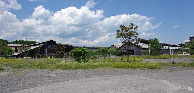
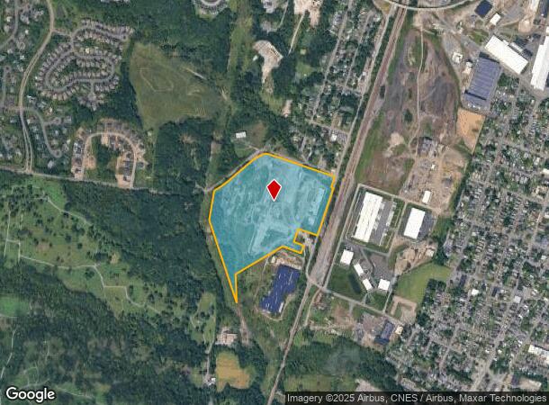
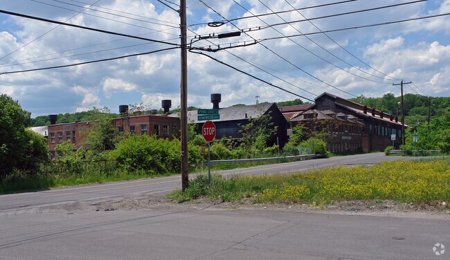
201 Spring Street Rd
012689-044-001-0001-007-001-0000
N-SPRING ST RD E-LINCOLN C-7-65
Industrialacreage
Albany
AE
New York
36001C0203D
7.001
2025
38.30 AC
2024
E Outer Albany County
013300
Albany/Schenectady/Troy
13,260 SF
Albany-Schenectady-Troy, NY
DEMOGRAPHICS near 201 Spring Street Rd
1 Mile
3 Mile
5 Mile
2024 Total Population
7,028
75,932
207,881
2029 Population
6,911
75,118
205,485
Pop Growth 2024-2029
(1.66%)
(1.07%)
(1.15%)
Average Age
36
38
39
2024 Total Households
2,585
31,347
90,030
HH Growth 2024-2029
(2.59%)
(1.13%)
(1.20%)
Median Household Inc
$68,132
$65,370
$61,685
Avg Household Size
2.10
2.10
2.10
2024 Avg HH Vehicles
2.00
1.00
1.00
Median Home Value
$186,120
$250,413
$233,342
Median Year Built
1959
1960
1958
Nearby Places
- Restaurants
- Banks
- Shops
- Fitness
- Groceries
PUBLIC TRANSPORTATION
COMMUTER RAIL
DRIVE
WALK
Distance
16 min
7.8 mi
AIRPORT
Albany International
DRIVE
WALK
Distance
Albany International
14 min
6.7 mi
Freight Ports
Albany, NY Port
DRIVE
WALK
Distance
Albany, NY Port
16 min
8.2 mi
Nearby Properties
Address
Land Use
TOTAL SIZE
Lot Size
Zoning
Address
Land Use
TOTAL SIZE
Lot Size
Zoning
34,971 SF
108.68 AC
CI
Address
Land Use
TOTAL SIZE
Lot Size
Zoning
18,340 SF
159.79 AC
04 - FARM
Address
Land Use
TOTAL SIZE
Lot Size
Zoning
313,907 SF
8.23 AC
CI
Address
Land Use
TOTAL SIZE
Lot Size
Zoning
120,579 SF
49.20 AC
CI
Address
Land Use
TOTAL SIZE
Lot Size
Zoning
326,350 SF
11.11 AC
I
Address
Land Use
TOTAL SIZE
Lot Size
Zoning
413,006 SF
37.94 AC
CI
Address
Land Use
TOTAL SIZE
Lot Size
Zoning
11,900 SF
28.60 AC
86
Address
Land Use
TOTAL SIZE
Lot Size
Zoning
365,400 SF
73.90 AC
04 - FARM
Address
Land Use
TOTAL SIZE
Lot Size
Zoning
38,176 SF
8.99 AC
06 - INDUS
Address
Land Use
TOTAL SIZE
Lot Size
Zoning
3,214 SF
412.83 AC
18
Address
Land Use
TOTAL SIZE
Lot Size
Zoning
70,548 SF
2.71 AC
DMU
Address
Land Use
TOTAL SIZE
Lot Size
Zoning
82,154 SF
3.62 AC
DMU
Address
Land Use
TOTAL SIZE
Lot Size
Zoning
18,144 SF
58.78 AC
25
Address
Land Use
TOTAL SIZE
Lot Size
Zoning
11,264 SF
34.83 AC
MF
Address
Land Use
TOTAL SIZE
Lot Size
Zoning
85.40 AC
M1
Address
Land Use
TOTAL SIZE
Lot Size
Zoning
19,274 SF
24.80 AC
84
Address
Land Use
TOTAL SIZE
Lot Size
Zoning
223,050 SF
85.68 AC
04 - FARM
Address
Land Use
TOTAL SIZE
Lot Size
Zoning
353,510 SF
2.94 AC
WMU
Address
Land Use
TOTAL SIZE
Lot Size
Zoning
10,271 SF
11.22 AC
05 - COMME
Address
Land Use
TOTAL SIZE
Lot Size
Zoning
2,428 SF
23.10 AC
R3A
Address
Land Use
TOTAL SIZE
Lot Size
Zoning
63,992 SF
20 AC
CM
Address
Land Use
TOTAL SIZE
Lot Size
Zoning
34.12 AC
Address
Land Use
TOTAL SIZE
Lot Size
Zoning
9,792 SF
7.98 AC
R3
Address
Land Use
TOTAL SIZE
Lot Size
Zoning
87,427 SF
20.30 AC
R1A
Address
Land Use
TOTAL SIZE
Lot Size
Zoning
77,928 SF
2.25 AC
WMU
Address
Land Use
TOTAL SIZE
Lot Size
Zoning
3,168 SF
21.70 AC
78
Address
Land Use
TOTAL SIZE
Lot Size
Zoning
105,094 SF
3.38 AC
MF
Address
Land Use
TOTAL SIZE
Lot Size
Zoning
80,891 SF
3.02 AC
04 - FARM
Address
Land Use
TOTAL SIZE
Lot Size
Zoning
32,000 SF
7.77 AC
M1
The World's #1 Commercial Real Estate Marketplace
Connect with us
© 2025 CoStar Group
The information above has been obtained from sources believed reliable. While we do not doubt its accuracy we have not verified it and make no guarantee, warranty or representation about it. It is your responsibility to independently confirm its accuracy and completeness. Any projections, opinions, assumptions, or estimates used are for example only and do not represent the current or future performance of the property. The value of this transaction to you depends on tax and other factors which should be evaluated by your tax, financial, and legal advisors. You and your advisors should conduct a careful, independent investigation of the property to determine to your satisfaction the suitability of the property for your needs.