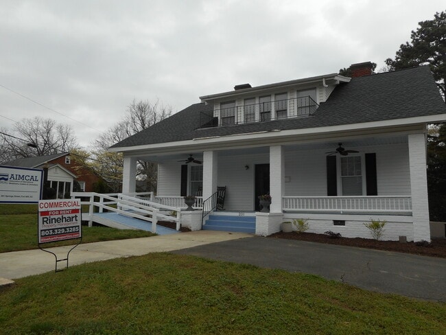
Property Record
201 Springs St, Fort Mill, SC 29715
NEARBY LISTINGS FOR SALE OR LEASE
Property Detail
201 Springs St
Charlotte-Concord-Gastonia, NC-SC
Whiteville Pk
0200407008
York
Residentialnec
South Carolina
X
1 AC
45091C0214F
York County
2,821 SF
Charlotte
DEMOGRAPHICS near 201 Springs St
1 Mile
3 Mile
5 Mile
2024 Total Population
5,207
35,738
127,182
2029 Population
5,840
40,679
144,814
Pop Growth 2024-2029
+ 12.16%
+ 13.83%
+ 13.86%
Average Age
40
38
38
2024 Total Households
2,142
12,934
47,639
HH Growth 2024-2029
+ 12.51%
+ 14.05%
+ 14.07%
Median Household Inc
$75,606
$111,808
$99,080
Avg Household Size
2.40
2.80
2.70
2024 Avg HH Vehicles
2.00
2.00
2.00
Median Home Value
$299,778
$406,764
$369,630
Median Year Built
1978
2005
2005
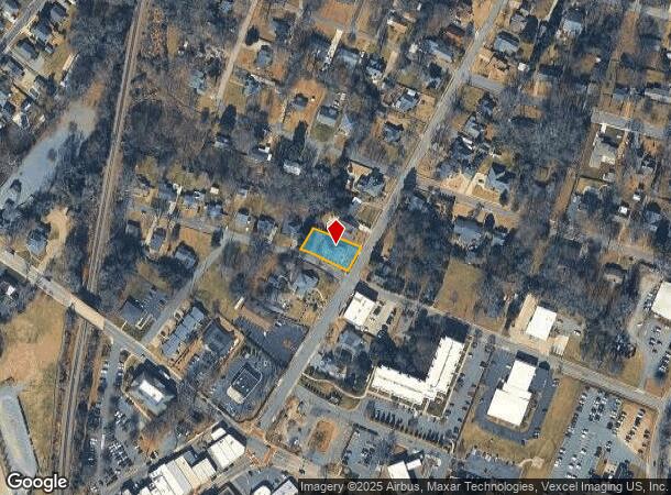
Nearby Places
Map Layers
Map Styles
 Street
 Aerial
- Restaurants
- Banks
- Shops
- Fitness
- Groceries
PUBLIC TRANSPORTATION
AIRPORT
Charlotte/Douglas International
DRIVE
WALK
Distance
Charlotte/Douglas International
30 min
17.1 mi
Concord-Padgett Regional
DRIVE
WALK
Distance
Concord-Padgett Regional
49 min
34.2 mi
Freight Ports
North Charleston Terminal
DRIVE
WALK
Distance
North Charleston Terminal
206 min
183.1 mi
SALE & LEASE HISTORY
LISTING DATE
SALE/LEASE

Jun 10, 2020
For Lease
Nearby Properties
Address
Land Use
TOTAL SIZE
Lot Size
Zoning
Address
Land Use
TOTAL SIZE
Lot Size
Zoning
401.79 AC
Address
Land Use
TOTAL SIZE
Lot Size
Zoning
335.85 AC
AGC
Address
Land Use
TOTAL SIZE
Lot Size
Zoning
64,338 SF
0.83 AC
Address
Land Use
TOTAL SIZE
Lot Size
Zoning
178,585 SF
17.44 AC
Address
Land Use
TOTAL SIZE
Lot Size
Zoning
167.49 AC
MULTIPLEZ
Address
Land Use
TOTAL SIZE
Lot Size
Zoning
162.78 AC
RCI
Address
Land Use
TOTAL SIZE
Lot Size
Zoning
64,113 SF
6.69 AC
Address
Land Use
TOTAL SIZE
Lot Size
Zoning
197,864 SF
39.37 AC
Address
Land Use
TOTAL SIZE
Lot Size
Zoning
79,600 SF
9.58 AC
Address
Land Use
TOTAL SIZE
Lot Size
Zoning
7,772 SF
4.75 AC
Address
Land Use
TOTAL SIZE
Lot Size
Zoning
598,425 SF
102 AC
ID
Address
Land Use
TOTAL SIZE
Lot Size
Zoning
26,733 SF
34.66 AC
PD
Address
Land Use
TOTAL SIZE
Lot Size
Zoning
28,569 SF
0.39 AC
Address
Land Use
TOTAL SIZE
Lot Size
Zoning
Address
Land Use
TOTAL SIZE
Lot Size
Zoning
25,554 SF
14.18 AC
PD
Address
Land Use
TOTAL SIZE
Lot Size
Zoning
18,990 SF
0.23 AC
Address
Land Use
TOTAL SIZE
Lot Size
Zoning
131,716 SF
13.89 AC
Address
Land Use
TOTAL SIZE
Lot Size
Zoning
21,761 SF
30.22 AC
AGC
Address
Land Use
TOTAL SIZE
Lot Size
Zoning
48,912 SF
14.66 AC
Address
Land Use
TOTAL SIZE
Lot Size
Zoning
280,000 SF
35.63 AC
ID
Address
Land Use
TOTAL SIZE
Lot Size
Zoning
10.57 AC
Address
Land Use
TOTAL SIZE
Lot Size
Zoning
5,750 SF
0.54 AC
Address
Land Use
TOTAL SIZE
Lot Size
Zoning
24,200 SF
2.18 AC
Address
Land Use
TOTAL SIZE
Lot Size
Zoning
4,058 SF
28.55 AC
AGC
Address
Land Use
TOTAL SIZE
Lot Size
Zoning
16.05 AC
Address
Land Use
TOTAL SIZE
Lot Size
Zoning
18.96 AC
TND
Address
Land Use
TOTAL SIZE
Lot Size
Zoning
77,363 SF
11.05 AC
Address
Land Use
TOTAL SIZE
Lot Size
Zoning
5,722 SF
1 AC
Address
Land Use
TOTAL SIZE
Lot Size
Zoning
4,358 SF
0.23 AC
Address
Land Use
TOTAL SIZE
Lot Size
Zoning
5,333 SF
1 AC
The World's #1 Commercial Real Estate Marketplace
Connect with us
© 2025 CoStar Group
The information above has been obtained from sources believed reliable. While we do not doubt its accuracy we have not verified it and make no guarantee, warranty or representation about it. It is your responsibility to independently confirm its accuracy and completeness. Any projections, opinions, assumptions, or estimates used are for example only and do not represent the current or future performance of the property. The value of this transaction to you depends on tax and other factors which should be evaluated by your tax, financial, and legal advisors. You and your advisors should conduct a careful, independent investigation of the property to determine to your satisfaction the suitability of the property for your needs.