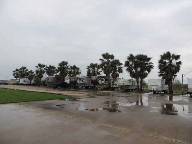
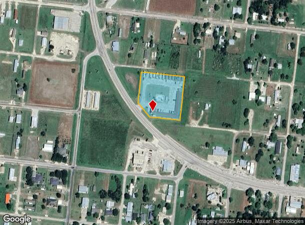
Property Record
201 State Highway 185 N, Seadrift, TX 77983
NEARBY LISTINGS FOR SALE OR LEASE
-
-
View all Seadrift listings for sale on LoopNet.com
Property Detail
201 State Highway 185 N
Port Lavaca, TX
Seadrift Townsite
28869
SEADRIFT TOWNSITE, BLOCK 65, LOT 1,2,3,7 THRU 12, PTS 4,5,6, & ABND ALLEYWAY
Commercialnec
Calhoun
X
Texas
48057C0340E
1-3
2025
1.98 AC
2025
Texas South Area
000502
Other Market Areas
10,200 SF
DEMOGRAPHICS near 201 State Highway 185 N
1 mile
3 mile
5 mile
2024 Total Population
696
1,050
1,135
2029 Population
626
956
1,034
Pop Growth 2024-2029
(10.06%)
(8.95%)
(8.90%)
Average Age
44
45
45
2024 Total Households
272
423
459
HH Growth 2024-2029
(9.93%)
(8.75%)
(8.71%)
Median Household Inc
$47,500
$54,687
$55,277
Avg Household Size
2.50
2.50
2.40
2024 Avg HH Vehicles
2.00
2.00
2.00
Median Home Value
$139,449
$148,287
$151,282
Median Year Built
1980
1988
1990
Nearby Places
Map Layers
Map Styles
 Street
 Aerial
Transit
 Traffic
 Biking
Places
Listings with unknown addresses are not visible on the map
- Restaurants
- Banks
- Shops
- Fitness
- Groceries
Nearby Properties
Address
Land Use
TOTAL SIZE
Lot Size
Zoning
Address
Land Use
TOTAL SIZE
Lot Size
Zoning
144 SF
10.96 AC
Address
Land Use
TOTAL SIZE
Lot Size
Zoning
56,320 SF
30 AC
Address
Land Use
TOTAL SIZE
Lot Size
Zoning
12,112 SF
29.54 AC
Address
Land Use
TOTAL SIZE
Lot Size
Zoning
9,434 SF
42 AC
Address
Land Use
TOTAL SIZE
Lot Size
Zoning
1,668 SF
566.78 AC
Address
Land Use
TOTAL SIZE
Lot Size
Zoning
3,031 SF
1.67 AC
Address
Land Use
TOTAL SIZE
Lot Size
Zoning
14,252 SF
148.14 AC
Address
Land Use
TOTAL SIZE
Lot Size
Zoning
3,082 SF
0.83 AC
Address
Land Use
TOTAL SIZE
Lot Size
Zoning
6,100 SF
1.13 AC
Address
Land Use
TOTAL SIZE
Lot Size
Zoning
2,776 SF
2.77 AC
Address
Land Use
TOTAL SIZE
Lot Size
Zoning
840 SF
19.16 AC
Address
Land Use
TOTAL SIZE
Lot Size
Zoning
2,462 SF
0.70 AC
Address
Land Use
TOTAL SIZE
Lot Size
Zoning
9,100 SF
0.98 AC
Address
Land Use
TOTAL SIZE
Lot Size
Zoning
7,164 SF
0.98 AC
Address
Land Use
TOTAL SIZE
Lot Size
Zoning
2,316 SF
1.10 AC
Address
Land Use
TOTAL SIZE
Lot Size
Zoning
2,990 SF
1.05 AC
Address
Land Use
TOTAL SIZE
Lot Size
Zoning
3,441 SF
0.39 AC
Address
Land Use
TOTAL SIZE
Lot Size
Zoning
2,500 SF
1.15 AC
Address
Land Use
TOTAL SIZE
Lot Size
Zoning
8,320 SF
0.90 AC
Address
Land Use
TOTAL SIZE
Lot Size
Zoning
151 SF
221.81 AC
Address
Land Use
TOTAL SIZE
Lot Size
Zoning
2,430 SF
0.87 AC
Address
Land Use
TOTAL SIZE
Lot Size
Zoning
2,291 SF
0.81 AC
Address
Land Use
TOTAL SIZE
Lot Size
Zoning
1,712 SF
0.69 AC
Address
Land Use
TOTAL SIZE
Lot Size
Zoning
18,302 SF
7.48 AC
Address
Land Use
TOTAL SIZE
Lot Size
Zoning
1,623 SF
0.67 AC
Address
Land Use
TOTAL SIZE
Lot Size
Zoning
263.19 AC
Address
Land Use
TOTAL SIZE
Lot Size
Zoning
7,434 SF
0.44 AC
The World's #1 Commercial Real Estate Marketplace
Connect with us
© 2026 CoStar Group
The information above has been obtained from sources believed reliable. While we do not doubt its accuracy we have not verified it and make no guarantee, warranty or representation about it. It is your responsibility to independently confirm its accuracy and completeness. Any projections, opinions, assumptions, or estimates used are for example only and do not represent the current or future performance of the property. The value of this transaction to you depends on tax and other factors which should be evaluated by your tax, financial, and legal advisors. You and your advisors should conduct a careful, independent investigation of the property to determine to your satisfaction the suitability of the property for your needs.