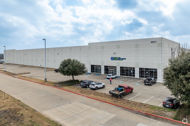
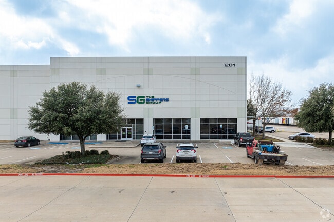
Property Record
201 Sunridge Blvd, Wilmer, TX 75172

NEARBY LISTINGS FOR SALE OR LEASE
Property Detail
201 Sunridge Blvd
Dallas-Fort Worth-Arlington, TX
Sunridge Business Park
540151500C0010000
SUNRIDGE BUSINESS PARK BLK C LOT 1.1 ACS 14.12 JURIS SPLIT SEE 540151500C0010000 INT201900051679 DD03012019 CO-DC 0151500C00101 4CT0151500C
Warehouse
Dallas
X
Texas
48113C0660K
1
2024
39.24 AC
2025
SE Dallas/I-45
016903
Dallas/Ft Worth
660,000 SF
DEMOGRAPHICS near 201 Sunridge Blvd
1 Mile
3 Mile
5 Mile
2024 Total Population
4,056
9,948
26,216
2029 Population
4,196
10,303
27,579
Pop Growth 2024-2029
+ 3.45%
+ 3.57%
+ 5.20%
Average Age
33
33
35
2024 Total Households
1,197
3,011
7,453
HH Growth 2024-2029
+ 3.43%
+ 3.42%
+ 5.69%
Median Household Inc
$42,045
$50,412
$48,129
Avg Household Size
3.20
3.20
3.20
2024 Avg HH Vehicles
2.00
2.00
2.00
Median Home Value
$81,924
$101,846
$133,993
Median Year Built
1995
1996
1991
Nearby Places
Map Layers
Map Styles
 Street
 Aerial
- Restaurants
- Banks
- Shops
- Fitness
- Groceries
PUBLIC TRANSPORTATION
AIRPORT
Dallas Love Field
DRIVE
WALK
Distance
Dallas Love Field
33 min
21.0 mi
Dallas-Fort Worth International
DRIVE
WALK
Distance
Dallas-Fort Worth International
48 min
36.9 mi
Freight Ports
Port of Shreveport
DRIVE
WALK
Distance
Port of Shreveport
213 min
196.9 mi
Nearby Properties
Address
Land Use
TOTAL SIZE
Lot Size
Zoning
Address
Land Use
TOTAL SIZE
Lot Size
Zoning
2,492,806 SF
273.09 AC
Z34
Address
Land Use
TOTAL SIZE
Lot Size
Zoning
36.33 AC
Z31
Address
Land Use
TOTAL SIZE
Lot Size
Zoning
1,409,184 SF
75.72 AC
Z31
Address
Land Use
TOTAL SIZE
Lot Size
Zoning
1,358,690 SF
94.91 AC
Z268
Address
Land Use
TOTAL SIZE
Lot Size
Zoning
1,225,000 SF
69.44 AC
Z04
Address
Land Use
TOTAL SIZE
Lot Size
Zoning
1,097,520 SF
58.28 AC
Address
Land Use
TOTAL SIZE
Lot Size
Zoning
1,073,520 SF
55.17 AC
Z123
Address
Land Use
TOTAL SIZE
Lot Size
Zoning
1,039,360 SF
64.13 AC
Z123
Address
Land Use
TOTAL SIZE
Lot Size
Zoning
1,021,601 SF
79.42 AC
Z268
Address
Land Use
TOTAL SIZE
Lot Size
Zoning
1,033,503 SF
51.34 AC
Address
Land Use
TOTAL SIZE
Lot Size
Zoning
1,020,000 SF
56.30 AC
Z31
Address
Land Use
TOTAL SIZE
Lot Size
Zoning
960,665 SF
46.03 AC
Z31
Address
Land Use
TOTAL SIZE
Lot Size
Zoning
799,765 SF
45.66 AC
Z31
Address
Land Use
TOTAL SIZE
Lot Size
Zoning
754,897 SF
42.75 AC
Z123
Address
Land Use
TOTAL SIZE
Lot Size
Zoning
698,880 SF
37.31 AC
Z31
Address
Land Use
TOTAL SIZE
Lot Size
Zoning
290,000 SF
51.91 AC
Z123
Address
Land Use
TOTAL SIZE
Lot Size
Zoning
750,000 SF
37.12 AC
Z31
Address
Land Use
TOTAL SIZE
Lot Size
Zoning
588,500 SF
32.61 AC
Z123
Address
Land Use
TOTAL SIZE
Lot Size
Zoning
540,000 SF
40.02 AC
Z67
Address
Land Use
TOTAL SIZE
Lot Size
Zoning
506,285 SF
26.49 AC
Address
Land Use
TOTAL SIZE
Lot Size
Zoning
571,880 SF
19.42 AC
Z123
Address
Land Use
TOTAL SIZE
Lot Size
Zoning
587,000 SF
33.94 AC
Z123
Address
Land Use
TOTAL SIZE
Lot Size
Zoning
626,100 SF
30.45 AC
Z398
Address
Land Use
TOTAL SIZE
Lot Size
Zoning
570,000 SF
30.48 AC
Z251
Address
Land Use
TOTAL SIZE
Lot Size
Zoning
565,259 SF
38.69 AC
Z123
Address
Land Use
TOTAL SIZE
Lot Size
Zoning
826,620 SF
39.67 AC
Z123
Address
Land Use
TOTAL SIZE
Lot Size
Zoning
132,780 SF
64.84 AC
Z05
Address
Land Use
TOTAL SIZE
Lot Size
Zoning
416,000 SF
28.69 AC
Z123
Address
Land Use
TOTAL SIZE
Lot Size
Zoning
611,040 SF
39.98 AC
Z251
The World's #1 Commercial Real Estate Marketplace
Connect with us
© 2026 CoStar Group
The information above has been obtained from sources believed reliable. While we do not doubt its accuracy we have not verified it and make no guarantee, warranty or representation about it. It is your responsibility to independently confirm its accuracy and completeness. Any projections, opinions, assumptions, or estimates used are for example only and do not represent the current or future performance of the property. The value of this transaction to you depends on tax and other factors which should be evaluated by your tax, financial, and legal advisors. You and your advisors should conduct a careful, independent investigation of the property to determine to your satisfaction the suitability of the property for your needs.