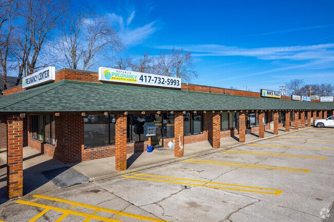
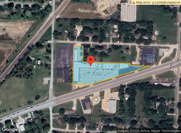
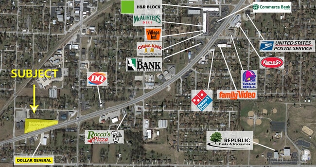
Property Record
201 Us Highway 60 W, Republic, MO 65738
Current Lease Availabilities
NEARBY LISTINGS FOR SALE OR LEASE
Property Detail
201 Us Highway 60 W
Springfield, MO
Jones
17-19-420-013
JONES ADD JWP LOT 23 S 20 FT LOT 24 THRU 28 LOT 33 THRU 38 N OF RR & ALL LOTS 39 & 40 & VAC ST S & ADJ LOT 38, 39 & 40
Communitycenter
Greene
X
Missouri
29043C0030D
23
2025
3.10 AC
2025
Outlying Greene County
004803
Springfield
38,069 SF
DEMOGRAPHICS near 201 Us Highway 60 W
1 Mile
3 Mile
5 Mile
2024 Total Population
8,066
20,677
25,601
2029 Population
8,467
21,653
26,961
Pop Growth 2024-2029
+ 4.97%
+ 4.72%
+ 5.31%
Average Age
37
37
37
2024 Total Households
3,030
7,680
9,597
HH Growth 2024-2029
+ 5.15%
+ 4.88%
+ 5.51%
Median Household Inc
$69,486
$65,980
$65,989
Avg Household Size
2.60
2.70
2.60
2024 Avg HH Vehicles
2.00
2.00
2.00
Median Home Value
$172,938
$176,688
$186,840
Median Year Built
1990
1992
1994
Nearby Places
Map Layers
Map Styles
 Street
 Aerial
- Restaurants
- Banks
- Shops
- Fitness
- Groceries
PUBLIC TRANSPORTATION
AIRPORT
Springfield-Branson Ntl
DRIVE
WALK
Distance
Springfield-Branson Ntl
31 min
16.0 mi
Freight Ports
Tulsa Port of Inola
DRIVE
WALK
Distance
Tulsa Port of Inola
187 min
165.5 mi
Nearby Properties
Address
Land Use
TOTAL SIZE
Lot Size
Zoning
Address
Land Use
TOTAL SIZE
Lot Size
Zoning
157,134 SF
18.35 AC
INC
Address
Land Use
TOTAL SIZE
Lot Size
Zoning
129,624 SF
10.94 AC
INC
Address
Land Use
TOTAL SIZE
Lot Size
Zoning
136,508 SF
16.42 AC
INC
Address
Land Use
TOTAL SIZE
Lot Size
Zoning
12.09 AC
Address
Land Use
TOTAL SIZE
Lot Size
Zoning
1,315 SF
7.58 AC
Address
Land Use
TOTAL SIZE
Lot Size
Zoning
5.24 AC
Address
Land Use
TOTAL SIZE
Lot Size
Zoning
8.65 AC
INC
Address
Land Use
TOTAL SIZE
Lot Size
Zoning
3.56 AC
INC
Address
Land Use
TOTAL SIZE
Lot Size
Zoning
80,344 SF
5.31 AC
INC
Address
Land Use
TOTAL SIZE
Lot Size
Zoning
10,726 SF
1.92 AC
INC
Address
Land Use
TOTAL SIZE
Lot Size
Zoning
9,960 SF
5.09 AC
INC
Address
Land Use
TOTAL SIZE
Lot Size
Zoning
46,775 SF
4.60 AC
INC
Address
Land Use
TOTAL SIZE
Lot Size
Zoning
27,924 SF
2.04 AC
INC
Address
Land Use
TOTAL SIZE
Lot Size
Zoning
76,794 SF
6.46 AC
INC
Address
Land Use
TOTAL SIZE
Lot Size
Zoning
17,848 SF
1.15 AC
INC
Address
Land Use
TOTAL SIZE
Lot Size
Zoning
1.28 AC
INC
Address
Land Use
TOTAL SIZE
Lot Size
Zoning
23,336 SF
4 AC
INC
Address
Land Use
TOTAL SIZE
Lot Size
Zoning
14,493 SF
2.33 AC
INC
Address
Land Use
TOTAL SIZE
Lot Size
Zoning
Address
Land Use
TOTAL SIZE
Lot Size
Zoning
10,742 SF
2.21 AC
INC
Address
Land Use
TOTAL SIZE
Lot Size
Zoning
41,504 SF
2.70 AC
INC
Address
Land Use
TOTAL SIZE
Lot Size
Zoning
45,756 SF
11.25 AC
INC
Address
Land Use
TOTAL SIZE
Lot Size
Zoning
3.31 AC
INC
Address
Land Use
TOTAL SIZE
Lot Size
Zoning
2.21 AC
INC
Address
Land Use
TOTAL SIZE
Lot Size
Zoning
1.26 AC
Address
Land Use
TOTAL SIZE
Lot Size
Zoning
15.52 AC
C-2
Address
Land Use
TOTAL SIZE
Lot Size
Zoning
2.08 AC
INC
Address
Land Use
TOTAL SIZE
Lot Size
Zoning
1.15 AC
Address
Land Use
TOTAL SIZE
Lot Size
Zoning
35,832 SF
5.33 AC
INC
The World's #1 Commercial Real Estate Marketplace
Connect with us
© 2025 CoStar Group
The information above has been obtained from sources believed reliable. While we do not doubt its accuracy we have not verified it and make no guarantee, warranty or representation about it. It is your responsibility to independently confirm its accuracy and completeness. Any projections, opinions, assumptions, or estimates used are for example only and do not represent the current or future performance of the property. The value of this transaction to you depends on tax and other factors which should be evaluated by your tax, financial, and legal advisors. You and your advisors should conduct a careful, independent investigation of the property to determine to your satisfaction the suitability of the property for your needs.