Property Record
201 W 20Th St, Mount Pleasant, TX 75455

Save to a Folder
{{folder.Name}}
{{folder.ListingIds.length}} Properties
{{folder.ListingIds.length}} Property
Create a New Folder
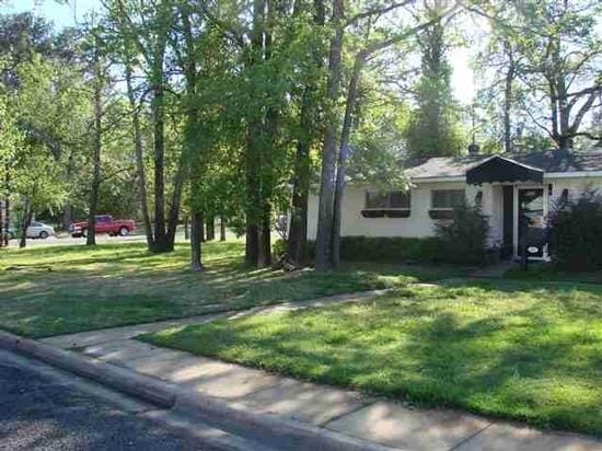
Property Detail
201 W 20Th St
Mount Pleasant, TX
FORD HIGHLANDS ADDITION BLK 7A LOT 1 .2479 AC
13391
Titus
Commercialnec
Texas
B and X Area of moderate flood hazard, usually the area between the limits of the 100-year and 500-year floods.
1
2025
0.25 AC
2025
Texas East Area
950600
Other Market Areas
4,432 SF
NEARBY LISTINGS FOR SALE OR LEASE
-
-
View all Mount Pleasant listings for sale on LoopNet.com
DEMOGRAPHICS near 201 W 20Th St
1 mile
3 mile
5 mile
2025 Total Population
4,123
17,458
20,554
2030 Population
4,158
17,606
20,749
Pop Growth 2025-2030
+ 0.85%
+ 0.85%
+ 0.95%
Average Age
36
36
37
2025 Total Households
1,374
5,868
6,955
HH Growth 2025-2030
+ 0.73%
+ 0.85%
+ 0.95%
Median Household Inc
$50,246
$56,311
$56,414
Avg Household Size
2.90
2.90
2.90
2025 Avg HH Vehicles
2.00
2.00
2.00
Median Home Value
$134,236
$163,701
$170,900
Median Year Built
1976
1980
1982
Nearby Places
Map Layers
Map Styles
 Street
 Aerial
Layers
 Traffic
 Biking
Places
Listings with unknown addresses are not visible on the map
- Restaurants
- Banks
- Shops
- Fitness
- Groceries
Nearby Properties
Address
Land Use
TOTAL SIZE
Lot Size
Zoning
Address
Land Use
TOTAL SIZE
Lot Size
Zoning
95,599 SF
4.90 AC
Address
Land Use
TOTAL SIZE
Lot Size
Zoning
226,756 SF
54 AC
Address
Land Use
TOTAL SIZE
Lot Size
Zoning
124,427 SF
75.76 AC
Address
Land Use
TOTAL SIZE
Lot Size
Zoning
67,614 SF
1.14 AC
Address
Land Use
TOTAL SIZE
Lot Size
Zoning
149,008 SF
17.05 AC
Address
Land Use
TOTAL SIZE
Lot Size
Zoning
140,330 SF
15.75 AC
Address
Land Use
TOTAL SIZE
Lot Size
Zoning
120,988 SF
17.77 AC
Address
Land Use
TOTAL SIZE
Lot Size
Zoning
185,550 SF
29.44 AC
Address
Land Use
TOTAL SIZE
Lot Size
Zoning
11,464 SF
45.43 AC
Address
Land Use
TOTAL SIZE
Lot Size
Zoning
37,100 SF
3.71 AC
Address
Land Use
TOTAL SIZE
Lot Size
Zoning
63,000 SF
21.89 AC
Address
Land Use
TOTAL SIZE
Lot Size
Zoning
205,867 SF
10.04 AC
Address
Land Use
TOTAL SIZE
Lot Size
Zoning
55,356 SF
7.56 AC
Address
Land Use
TOTAL SIZE
Lot Size
Zoning
227,312 SF
46.36 AC
Address
Land Use
TOTAL SIZE
Lot Size
Zoning
50,810 SF
3.68 AC
Address
Land Use
TOTAL SIZE
Lot Size
Zoning
104,839 SF
2.79 AC
Address
Land Use
TOTAL SIZE
Lot Size
Zoning
49,836 SF
6.47 AC
Address
Land Use
TOTAL SIZE
Lot Size
Zoning
109,702 SF
18.89 AC
Address
Land Use
TOTAL SIZE
Lot Size
Zoning
83,468 SF
7.14 AC
Address
Land Use
TOTAL SIZE
Lot Size
Zoning
12,968 SF
2.19 AC
Address
Land Use
TOTAL SIZE
Lot Size
Zoning
138,200 SF
12.99 AC
Address
Land Use
TOTAL SIZE
Lot Size
Zoning
770 SF
171.30 AC
Address
Land Use
TOTAL SIZE
Lot Size
Zoning
18,240 SF
29.45 AC
Address
Land Use
TOTAL SIZE
Lot Size
Zoning
70,728 SF
1.70 AC
Address
Land Use
TOTAL SIZE
Lot Size
Zoning
14,860 SF
2.10 AC
Address
Land Use
TOTAL SIZE
Lot Size
Zoning
9,468 SF
107.30 AC
Address
Land Use
TOTAL SIZE
Lot Size
Zoning
80,719 SF
4.81 AC
Address
Land Use
TOTAL SIZE
Lot Size
Zoning
36,769 SF
10.55 AC
Address
Land Use
TOTAL SIZE
Lot Size
Zoning
20,713 SF
5.54 AC
Address
Land Use
TOTAL SIZE
Lot Size
Zoning
17,552 SF
1.32 AC
The World's #1 Commercial Real Estate Marketplace
Connect with us
© 2026 CoStar Group
The information above has been obtained from sources believed reliable. While we do not doubt its accuracy we have not verified it and make no guarantee, warranty or representation about it. It is your responsibility to independently confirm its accuracy and completeness. Any projections, opinions, assumptions, or estimates used are for example only and do not represent the current or future performance of the property. The value of this transaction to you depends on tax and other factors which should be evaluated by your tax, financial, and legal advisors. You and your advisors should conduct a careful, independent investigation of the property to determine to your satisfaction the suitability of the property for your needs.