Property Record
201 W 4Th St, Casa Grande, AZ 85122
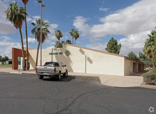

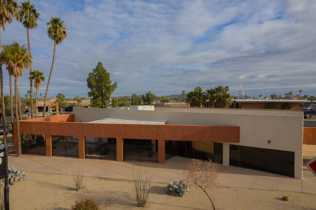
This Property Is For Sale
NEARBY LISTINGS FOR SALE OR LEASE
Property Detail
201 W 4Th St
Phoenix-Mesa-Scottsdale, AZ
Central
507-07-430
COMMENCING AT THE NORTHEASTERLY CORNER OF CENTRAL PLAZA AS AMENDE D AND RECORDED IN BOOK 18 PAGE 41; THENCE NORTH 54 DEGREES WEST 1 22.00 FEET TO THE POINT OF BEGINNING; THENCE CONTINUING NORTH 54 DEGREES WEST 49.00 FEET TO A POINT OF CURVE; THENCE N
Officebuilding
Pinal
2023
Arizona
2025
0.42 AC
0014061020
Pinal County
7,516 SF
Phoenix
DEMOGRAPHICS near 201 W 4Th St
1 Mile
3 Mile
5 Mile
2024 Total Population
10,304
42,071
63,433
2029 Population
13,045
53,220
80,604
Pop Growth 2024-2029
+ 26.60%
+ 26.50%
+ 27.07%
Average Age
37
40
41
2024 Total Households
3,489
15,645
23,207
HH Growth 2024-2029
+ 26.00%
+ 25.91%
+ 26.60%
Median Household Inc
$47,500
$58,483
$63,017
Avg Household Size
2.80
2.60
2.60
2024 Avg HH Vehicles
2.00
2.00
2.00
Median Home Value
$157,153
$205,592
$246,433
Median Year Built
1975
1998
2001
Nearby Places
Map Layers
Map Styles
 Street
 Aerial
- Restaurants
- Banks
- Shops
- Fitness
- Groceries
PUBLIC TRANSPORTATION
AIRPORT
Phoenix-Mesa Gateway
DRIVE
WALK
Distance
Phoenix-Mesa Gateway
61 min
41.4 mi
Freight Ports
Port of San Diego
DRIVE
WALK
Distance
Port of San Diego
374 min
349.2 mi
Nearby Properties
Address
Land Use
TOTAL SIZE
Lot Size
Zoning
Address
Land Use
TOTAL SIZE
Lot Size
Zoning
3,431,931 SF
47.73 AC
Address
Land Use
TOTAL SIZE
Lot Size
Zoning
615,446 SF
88.25 AC
Address
Land Use
TOTAL SIZE
Lot Size
Zoning
877,742 SF
125.20 AC
UNDESIGNAT
Address
Land Use
TOTAL SIZE
Lot Size
Zoning
525,773 SF
27.24 AC
UNDESIGNAT
Address
Land Use
TOTAL SIZE
Lot Size
Zoning
223,443 SF
176.81 AC
Address
Land Use
TOTAL SIZE
Lot Size
Zoning
216,795 SF
11.15 AC
Address
Land Use
TOTAL SIZE
Lot Size
Zoning
380,964 SF
36.62 AC
UNDESIGNAT
Address
Land Use
TOTAL SIZE
Lot Size
Zoning
286,759 SF
37.76 AC
UNDESIGNAT
Address
Land Use
TOTAL SIZE
Lot Size
Zoning
123,963 SF
15.43 AC
UNDESIGNAT
Address
Land Use
TOTAL SIZE
Lot Size
Zoning
222,134 SF
24.14 AC
Address
Land Use
TOTAL SIZE
Lot Size
Zoning
196,294 SF
4.24 AC
Address
Land Use
TOTAL SIZE
Lot Size
Zoning
172,746 SF
14.70 AC
UNDESIGNAT
Address
Land Use
TOTAL SIZE
Lot Size
Zoning
264,993 SF
26.48 AC
Address
Land Use
TOTAL SIZE
Lot Size
Zoning
55,295 SF
12.14 AC
Address
Land Use
TOTAL SIZE
Lot Size
Zoning
131,275 SF
8.85 AC
Address
Land Use
TOTAL SIZE
Lot Size
Zoning
81,467 SF
11.96 AC
Address
Land Use
TOTAL SIZE
Lot Size
Zoning
121,969 SF
9.36 AC
Address
Land Use
TOTAL SIZE
Lot Size
Zoning
93,477 SF
4.22 AC
UNDESIGNAT
Address
Land Use
TOTAL SIZE
Lot Size
Zoning
111,066 SF
5.04 AC
UNDESIGNAT
Address
Land Use
TOTAL SIZE
Lot Size
Zoning
100,149 SF
10.59 AC
Address
Land Use
TOTAL SIZE
Lot Size
Zoning
137,735 SF
14.12 AC
Address
Land Use
TOTAL SIZE
Lot Size
Zoning
156,264 SF
10.70 AC
UNDESIGNAT
Address
Land Use
TOTAL SIZE
Lot Size
Zoning
395,597 SF
13.81 AC
Address
Land Use
TOTAL SIZE
Lot Size
Zoning
0.12 AC
Address
Land Use
TOTAL SIZE
Lot Size
Zoning
74,433 SF
15.44 AC
UNDESIGNAT
Address
Land Use
TOTAL SIZE
Lot Size
Zoning
43,355 SF
5.91 AC
Address
Land Use
TOTAL SIZE
Lot Size
Zoning
33.70 AC
Address
Land Use
TOTAL SIZE
Lot Size
Zoning
320,334 SF
9.38 AC
The World's #1 Commercial Real Estate Marketplace
Connect with us
© 2026 CoStar Group
The information above has been obtained from sources believed reliable. While we do not doubt its accuracy we have not verified it and make no guarantee, warranty or representation about it. It is your responsibility to independently confirm its accuracy and completeness. Any projections, opinions, assumptions, or estimates used are for example only and do not represent the current or future performance of the property. The value of this transaction to you depends on tax and other factors which should be evaluated by your tax, financial, and legal advisors. You and your advisors should conduct a careful, independent investigation of the property to determine to your satisfaction the suitability of the property for your needs.