Property Record
201 9Th St, Burnet, TX 78611

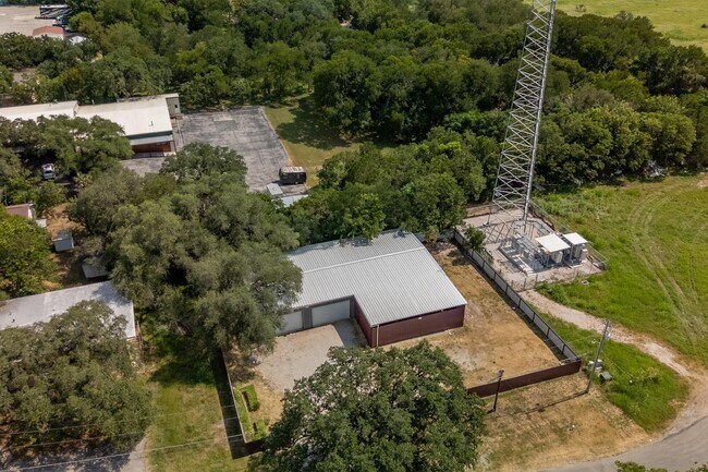
Property Detail
201 9Th St
83503
S7204 PALM VALLEY LOT 2
Commercialnec
Burnet
B and X Area of moderate flood hazard, usually the area between the limits of the 100-year and 500-year floods.
Texas
2024
2
2025
0.28 AC
960302
Burnet
3,200 SF
Other Market Areas
NEARBY LISTINGS FOR SALE OR LEASE
DEMOGRAPHICS near 201 9Th St
1 mile
3 mile
5 mile
2025 Total Population
3,912
8,303
10,921
2030 Population
4,253
9,086
11,975
Pop Growth 2025-2030
+ 8.72%
+ 9.43%
+ 9.65%
Average Age
40
41
42
2025 Total Households
1,421
2,976
3,979
HH Growth 2025-2030
+ 8.59%
+ 9.34%
+ 9.60%
Median Household Inc
$79,526
$76,653
$82,643
Avg Household Size
2.40
2.50
2.40
2025 Avg HH Vehicles
2.00
2.00
2.00
Median Home Value
$258,359
$280,598
$309,923
Median Year Built
1985
1994
1996
Nearby Places
Map Layers
Map Styles
 Street
 Aerial
Transit
 Traffic
 Biking
Places
Listings with unknown addresses are not visible on the map
- Restaurants
- Banks
- Shops
- Fitness
- Groceries
PUBLIC TRANSPORTATION
AIRPORT
Robert Gray AAF
Drive
Walk
Distance
Robert Gray AAF
59 min
45.9 mi
SALE & LEASE HISTORY
LISTING DATE
SALE/LEASE

Aug 12, 2025
For Sale
Nearby Properties
Address
Land Use
TOTAL SIZE
Lot Size
Zoning
Address
Land Use
TOTAL SIZE
Lot Size
Zoning
262,985 SF
57.03 AC
Address
Land Use
TOTAL SIZE
Lot Size
Zoning
203,874 SF
49.80 AC
Address
Land Use
TOTAL SIZE
Lot Size
Zoning
97,268 SF
75 AC
Address
Land Use
TOTAL SIZE
Lot Size
Zoning
93,830 SF
90.90 AC
Address
Land Use
TOTAL SIZE
Lot Size
Zoning
86,559 SF
4.65 AC
Address
Land Use
TOTAL SIZE
Lot Size
Zoning
65,788 SF
29.44 AC
Address
Land Use
TOTAL SIZE
Lot Size
Zoning
82,820 SF
20 AC
Address
Land Use
TOTAL SIZE
Lot Size
Zoning
78,771 SF
15.59 AC
Address
Land Use
TOTAL SIZE
Lot Size
Zoning
52,976 SF
7.99 AC
Address
Land Use
TOTAL SIZE
Lot Size
Zoning
89,309 SF
195.02 AC
Address
Land Use
TOTAL SIZE
Lot Size
Zoning
61,310 SF
34.07 AC
Address
Land Use
TOTAL SIZE
Lot Size
Zoning
33,300 SF
4.32 AC
Address
Land Use
TOTAL SIZE
Lot Size
Zoning
34,175 SF
3 AC
Address
Land Use
TOTAL SIZE
Lot Size
Zoning
30,325 SF
11.05 AC
Address
Land Use
TOTAL SIZE
Lot Size
Zoning
33,708 SF
10.35 AC
Address
Land Use
TOTAL SIZE
Lot Size
Zoning
459.47 AC
Address
Land Use
TOTAL SIZE
Lot Size
Zoning
10,882 SF
18.09 AC
Address
Land Use
TOTAL SIZE
Lot Size
Zoning
52,235 SF
2.98 AC
Address
Land Use
TOTAL SIZE
Lot Size
Zoning
12,837 SF
4.41 AC
Address
Land Use
TOTAL SIZE
Lot Size
Zoning
30,192 SF
8.55 AC
Address
Land Use
TOTAL SIZE
Lot Size
Zoning
45,581 SF
9.77 AC
Address
Land Use
TOTAL SIZE
Lot Size
Zoning
10,611 SF
9.15 AC
Address
Land Use
TOTAL SIZE
Lot Size
Zoning
27,879 SF
6.30 AC
Address
Land Use
TOTAL SIZE
Lot Size
Zoning
39,774 SF
6.94 AC
Address
Land Use
TOTAL SIZE
Lot Size
Zoning
25,608 SF
1.84 AC
Address
Land Use
TOTAL SIZE
Lot Size
Zoning
24,570 SF
0.95 AC
Address
Land Use
TOTAL SIZE
Lot Size
Zoning
72,734 SF
8 AC
Address
Land Use
TOTAL SIZE
Lot Size
Zoning
23,750 SF
5.72 AC
Address
Land Use
TOTAL SIZE
Lot Size
Zoning
28,616 SF
4.03 AC
Address
Land Use
TOTAL SIZE
Lot Size
Zoning
15,526 SF
2.28 AC
The World's #1 Commercial Real Estate Marketplace
Connect with us
© 2026 CoStar Group
The information above has been obtained from sources believed reliable. While we do not doubt its accuracy we have not verified it and make no guarantee, warranty or representation about it. It is your responsibility to independently confirm its accuracy and completeness. Any projections, opinions, assumptions, or estimates used are for example only and do not represent the current or future performance of the property. The value of this transaction to you depends on tax and other factors which should be evaluated by your tax, financial, and legal advisors. You and your advisors should conduct a careful, independent investigation of the property to determine to your satisfaction the suitability of the property for your needs.