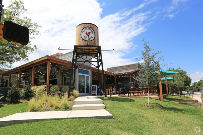
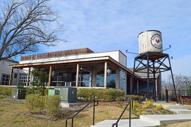
Property Record
201 W Church St, Lewisville, TX 75057


Property Detail
201 W Church St
Dallas-Fort Worth-Arlington, TX
LEWISVILLE TOWN SQUARE ADDITION BLK A LOT 3
R658816
Denton
Commercialnec
Texas
B and X Area of moderate flood hazard, usually the area between the limits of the 100-year and 500-year floods.
3
2025
0.61 AC
2025
Lewisville
021618
Dallas/Ft Worth
5,449 SF
NEARBY LISTINGS FOR SALE OR LEASE
DEMOGRAPHICS near 201 W Church St
1 mile
3 mile
5 mile
2025 Total Population
11,752
90,694
211,970
2030 Population
13,347
101,028
235,199
Pop Growth 2025-2030
+ 13.57%
+ 11.39%
+ 10.96%
Average Age
36
38
39
2025 Total Households
3,746
33,925
79,742
HH Growth 2025-2030
+ 14.04%
+ 11.61%
+ 11.30%
Median Household Inc
$76,460
$81,827
$100,403
Avg Household Size
2.90
2.60
2.60
2025 Avg HH Vehicles
2.00
2.00
2.00
Median Home Value
$253,798
$345,044
$425,351
Median Year Built
1986
1990
1995
Nearby Places
Map Layers
Map Styles
 Street
 Aerial
Layers
 Traffic
 Biking
Places
Listings with unknown addresses are not visible on the map
- Restaurants
- Banks
- Shops
- Fitness
- Groceries
PUBLIC TRANSPORTATION
COMMUTER RAIL
Old Town Station (A-train - Denton County Transportation Authority)
Drive
Walk
Distance
Old Town Station (A-train - Denton County Transportation Authority)
2 min
16 min
0.8 mi
Highland Village/Lewisville Lake Station (A-train - Denton County Transportation Authority)
Drive
Walk
Distance
Highland Village/Lewisville Lake Station (A-train - Denton County Transportation Authority)
5 min
3.4 mi
AIRPORT
Dallas-Fort Worth International
Drive
Walk
Distance
Dallas-Fort Worth International
18 min
12.2 mi
Dallas Love Field
Drive
Walk
Distance
Dallas Love Field
30 min
21.9 mi
Freight Ports
Port of Shreveport
Drive
Walk
Distance
Port of Shreveport
237 min
219.5 mi
SALE & LEASE HISTORY
LISTING DATE
SALE/LEASE

Sep 11, 2019
For Sale
Sep 11, 2019
For Lease
Feb 14, 2019
For Sale
Nearby Properties
Address
Land Use
TOTAL SIZE
Lot Size
Zoning
Address
Land Use
TOTAL SIZE
Lot Size
Zoning
334,685 SF
38.12 AC
Address
Land Use
TOTAL SIZE
Lot Size
Zoning
599,705 SF
10.38 AC
Address
Land Use
TOTAL SIZE
Lot Size
Zoning
323,048 SF
14.78 AC
Address
Land Use
TOTAL SIZE
Lot Size
Zoning
382,330 SF
21.43 AC
3B
Address
Land Use
TOTAL SIZE
Lot Size
Zoning
412,389 SF
16.69 AC
3B
Address
Land Use
TOTAL SIZE
Lot Size
Zoning
340,081 SF
18.06 AC
6
Address
Land Use
TOTAL SIZE
Lot Size
Zoning
380,316 SF
26.10 AC
Address
Land Use
TOTAL SIZE
Lot Size
Zoning
295,098 SF
10.65 AC
Address
Land Use
TOTAL SIZE
Lot Size
Zoning
392,646 SF
19.65 AC
3B
Address
Land Use
TOTAL SIZE
Lot Size
Zoning
266,959 SF
3.83 AC
Address
Land Use
TOTAL SIZE
Lot Size
Zoning
297,636 SF
9.43 AC
Address
Land Use
TOTAL SIZE
Lot Size
Zoning
295,668 SF
13.03 AC
Address
Land Use
TOTAL SIZE
Lot Size
Zoning
659,218 SF
34.29 AC
Address
Land Use
TOTAL SIZE
Lot Size
Zoning
345,310 SF
11.71 AC
Address
Land Use
TOTAL SIZE
Lot Size
Zoning
599,800 SF
31.44 AC
Address
Land Use
TOTAL SIZE
Lot Size
Zoning
288,735 SF
15.50 AC
3B
Address
Land Use
TOTAL SIZE
Lot Size
Zoning
344,932 SF
18.28 AC
3G
Address
Land Use
TOTAL SIZE
Lot Size
Zoning
212,454 SF
13 AC
6B
Address
Land Use
TOTAL SIZE
Lot Size
Zoning
572,808 SF
25.26 AC
Address
Land Use
TOTAL SIZE
Lot Size
Zoning
244,310 SF
6.24 AC
Address
Land Use
TOTAL SIZE
Lot Size
Zoning
440,000 SF
3.67 AC
Address
Land Use
TOTAL SIZE
Lot Size
Zoning
99,272 SF
16.60 AC
Address
Land Use
TOTAL SIZE
Lot Size
Zoning
241,095 SF
13.02 AC
Address
Land Use
TOTAL SIZE
Lot Size
Zoning
199,121 SF
9.90 AC
3B
Address
Land Use
TOTAL SIZE
Lot Size
Zoning
259,728 SF
14.30 AC
3G
Address
Land Use
TOTAL SIZE
Lot Size
Zoning
241,592 SF
11.09 AC
3G
Address
Land Use
TOTAL SIZE
Lot Size
Zoning
230,332 SF
11.09 AC
3B
Address
Land Use
TOTAL SIZE
Lot Size
Zoning
268,441 SF
13.89 AC
3G
Address
Land Use
TOTAL SIZE
Lot Size
Zoning
134,061 SF
17.87 AC
Address
Land Use
TOTAL SIZE
Lot Size
Zoning
221,320 SF
12.79 AC
6B
The World's #1 Commercial Real Estate Marketplace
Connect with us
© 2026 CoStar Group
The information above has been obtained from sources believed reliable. While we do not doubt its accuracy we have not verified it and make no guarantee, warranty or representation about it. It is your responsibility to independently confirm its accuracy and completeness. Any projections, opinions, assumptions, or estimates used are for example only and do not represent the current or future performance of the property. The value of this transaction to you depends on tax and other factors which should be evaluated by your tax, financial, and legal advisors. You and your advisors should conduct a careful, independent investigation of the property to determine to your satisfaction the suitability of the property for your needs.