Property Record
201 W Evergreen St, Strafford, MO 65757
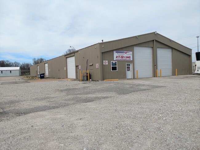


Property Detail
201 W Evergreen St
10-34-405-004
STRAFFORD IRR 5.42A M/L BEG 1267.57 FT S NW COR W1/2 SE1/4 3 4/30/20 E 414 FTSWLY 60 FT SLY 222.59 FT SELY 311.3 FT SWLY ALG N LINE TO W1/4 SEC LINE NLY TOPT OF BEG
Warehouse
Greene
INC
Missouri
B and X Area of moderate flood hazard, usually the area between the limits of the 100-year and 500-year floods.
5.42 AC
2025
Outlying Greene County
2025
Springfield
004601
Springfield, MO
30,000 SF
NEARBY LISTINGS FOR SALE OR LEASE
DEMOGRAPHICS near 201 W Evergreen St
1 mile
3 mile
5 mile
2025 Total Population
2,414
4,597
8,929
2030 Population
2,513
4,783
9,288
Pop Growth 2025-2030
+ 4.10%
+ 4.05%
+ 4.02%
Average Age
39
40
41
2025 Total Households
915
1,745
3,459
HH Growth 2025-2030
+ 4.37%
+ 4.18%
+ 4.16%
Median Household Inc
$69,764
$74,525
$80,945
Avg Household Size
2.50
2.60
2.50
2025 Avg HH Vehicles
2.00
2.00
2.00
Median Home Value
$194,220
$223,333
$278,375
Median Year Built
1990
1989
1989
Nearby Places
Map Layers
Map Styles
 Street
 Aerial
Layers
 Traffic
 Biking
Places
Listings with unknown addresses are not visible on the map
- Restaurants
- Banks
- Shops
- Fitness
- Groceries
PUBLIC TRANSPORTATION
AIRPORT
Springfield-Branson Ntl
Drive
Walk
Distance
Springfield-Branson Ntl
21 min
18.3 mi
Freight Ports
Port of Shreveport
Drive
Walk
Distance
Port of Shreveport
1 min
340.9 mi
SALE & LEASE HISTORY
LISTING DATE
SALE/LEASE

Apr 07, 2020
For Lease
Nearby Properties
Address
Land Use
TOTAL SIZE
Lot Size
Zoning
Address
Land Use
TOTAL SIZE
Lot Size
Zoning
9.17 AC
INC.
Address
Land Use
TOTAL SIZE
Lot Size
Zoning
8.66 AC
INC
Address
Land Use
TOTAL SIZE
Lot Size
Zoning
10.11 AC
INC
Address
Land Use
TOTAL SIZE
Lot Size
Zoning
85.20 AC
Address
Land Use
TOTAL SIZE
Lot Size
Zoning
18,820 SF
24.63 AC
Address
Land Use
TOTAL SIZE
Lot Size
Zoning
10.07 AC
INC.
Address
Land Use
TOTAL SIZE
Lot Size
Zoning
17.48 AC
INC
Address
Land Use
TOTAL SIZE
Lot Size
Zoning
Address
Land Use
TOTAL SIZE
Lot Size
Zoning
17.36 AC
INC.
Address
Land Use
TOTAL SIZE
Lot Size
Zoning
10 AC
INC.
Address
Land Use
TOTAL SIZE
Lot Size
Zoning
12.03 AC
INC
Address
Land Use
TOTAL SIZE
Lot Size
Zoning
14.70 AC
M-1
Address
Land Use
TOTAL SIZE
Lot Size
Zoning
61,640 SF
34.65 AC
INC
Address
Land Use
TOTAL SIZE
Lot Size
Zoning
Address
Land Use
TOTAL SIZE
Lot Size
Zoning
2.97 AC
INC
Address
Land Use
TOTAL SIZE
Lot Size
Zoning
22,000 SF
13.72 AC
Address
Land Use
TOTAL SIZE
Lot Size
Zoning
23,806 SF
42.74 AC
INC
Address
Land Use
TOTAL SIZE
Lot Size
Zoning
2.79 AC
INC
Address
Land Use
TOTAL SIZE
Lot Size
Zoning
6.93 AC
INC
Address
Land Use
TOTAL SIZE
Lot Size
Zoning
31,101 SF
12 AC
INC
Address
Land Use
TOTAL SIZE
Lot Size
Zoning
1,364 SF
14.79 AC
INC
Address
Land Use
TOTAL SIZE
Lot Size
Zoning
8.98 AC
INC
Address
Land Use
TOTAL SIZE
Lot Size
Zoning
Address
Land Use
TOTAL SIZE
Lot Size
Zoning
22,450 SF
31.65 AC
INC
Address
Land Use
TOTAL SIZE
Lot Size
Zoning
14,080 SF
10.71 AC
Address
Land Use
TOTAL SIZE
Lot Size
Zoning
2.06 AC
INC.
Address
Land Use
TOTAL SIZE
Lot Size
Zoning
23,636 SF
10.20 AC
INC
Address
Land Use
TOTAL SIZE
Lot Size
Zoning
8,146 SF
2.32 AC
INC
Address
Land Use
TOTAL SIZE
Lot Size
Zoning
4,253 SF
26.40 AC
INC
Address
Land Use
TOTAL SIZE
Lot Size
Zoning
16.22 AC
The World's #1 Commercial Real Estate Marketplace
Connect with us
© 2026 CoStar Group
The information above has been obtained from sources believed reliable. While we do not doubt its accuracy we have not verified it and make no guarantee, warranty or representation about it. It is your responsibility to independently confirm its accuracy and completeness. Any projections, opinions, assumptions, or estimates used are for example only and do not represent the current or future performance of the property. The value of this transaction to you depends on tax and other factors which should be evaluated by your tax, financial, and legal advisors. You and your advisors should conduct a careful, independent investigation of the property to determine to your satisfaction the suitability of the property for your needs.