Property Record
201 W Montauk Hwy, Hampton Bays, NY 11946
NEARBY LISTINGS FOR SALE OR LEASE
-
-
View all Hampton Bays listings for sale on LoopNet.com
Property Detail
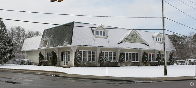
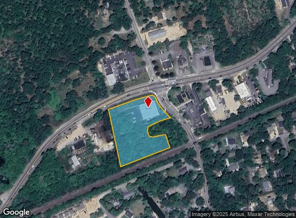
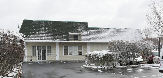
201 W Montauk Hwy
0900-255-00-01-00-001-002
03 SPLIT PER APPORTIONMETOWN6/9/88 89 BOR N/C 9MAPPED TOCORRECT CONFIG &
Storebuilding
Suffolk
AE
New York
36103C0781H
1
0
2.35 AC
2024
Eastern Suffolk
190403
Long Island (New York)
5,000 SF
Nassau County-Suffolk County, NY
DEMOGRAPHICS near 201 W Montauk Hwy
1 Mile
3 Mile
5 Mile
2024 Total Population
4,026
22,950
32,526
2029 Population
4,106
23,591
33,373
Pop Growth 2024-2029
+ 1.99%
+ 2.79%
+ 2.60%
Average Age
41
42
42
2024 Total Households
1,489
8,554
12,001
HH Growth 2024-2029
+ 1.95%
+ 2.72%
+ 2.52%
Median Household Inc
$101,507
$109,766
$109,998
Avg Household Size
2.60
2.60
2.60
2024 Avg HH Vehicles
2.00
2.00
2.00
Median Home Value
$707,204
$725,936
$723,222
Median Year Built
1974
1974
1975
Nearby Places
- Restaurants
- Banks
- Shops
- Fitness
- Groceries
PUBLIC TRANSPORTATION
COMMUTER RAIL
Hampton Bays Station (Montauk Branch - Long Island Rail Road)
DRIVE
WALK
Distance
Hampton Bays Station (Montauk Branch - Long Island Rail Road)
2 min
1.3 mi
Westhampton Station (Montauk Branch - Long Island Rail Road)
DRIVE
WALK
Distance
Westhampton Station (Montauk Branch - Long Island Rail Road)
13 min
8.2 mi
AIRPORT
Long Island MacArthur
DRIVE
WALK
Distance
Long Island MacArthur
48 min
33.1 mi
Freight Ports
Port of New Haven
DRIVE
WALK
Distance
Port of New Haven
161 min
68.4 mi
Nearby Properties
Address
Land Use
TOTAL SIZE
Lot Size
Zoning
Address
Land Use
TOTAL SIZE
Lot Size
Zoning
16,677 SF
25.40 AC
R20
Address
Land Use
TOTAL SIZE
Lot Size
Zoning
47,996 SF
19.50 AC
R20
Address
Land Use
TOTAL SIZE
Lot Size
Zoning
200,320 SF
7.34 AC
MUPDD
Address
Land Use
TOTAL SIZE
Lot Size
Zoning
41 AC
IND-R
Address
Land Use
TOTAL SIZE
Lot Size
Zoning
2.64 AC
B3
Address
Land Use
TOTAL SIZE
Lot Size
Zoning
660,340 SF
8.50 AC
MF44
Address
Land Use
TOTAL SIZE
Lot Size
Zoning
23,691 SF
5.65 AC
MPDD
Address
Land Use
TOTAL SIZE
Lot Size
Zoning
70,960 SF
8.29 AC
SCB
Address
Land Use
TOTAL SIZE
Lot Size
Zoning
2,568 SF
17.10 AC
HB
Address
Land Use
TOTAL SIZE
Lot Size
Zoning
26.76 AC
CR200
Address
Land Use
TOTAL SIZE
Lot Size
Zoning
217 AC
H2O
Address
Land Use
TOTAL SIZE
Lot Size
Zoning
126,936 SF
41 AC
OSC
Address
Land Use
TOTAL SIZE
Lot Size
Zoning
16,249 SF
7.40 AC
R40
Address
Land Use
TOTAL SIZE
Lot Size
Zoning
13.88 AC
CR200
Address
Land Use
TOTAL SIZE
Lot Size
Zoning
238,520 SF
10.03 AC
SC44
Address
Land Use
TOTAL SIZE
Lot Size
Zoning
12.90 AC
R80
Address
Land Use
TOTAL SIZE
Lot Size
Zoning
30,124 SF
10.20 AC
R20
Address
Land Use
TOTAL SIZE
Lot Size
Zoning
120,152 SF
20.50 AC
OSC
Address
Land Use
TOTAL SIZE
Lot Size
Zoning
67,796 SF
7 AC
SCB
Address
Land Use
TOTAL SIZE
Lot Size
Zoning
14,470 SF
4.20 AC
CR120
Address
Land Use
TOTAL SIZE
Lot Size
Zoning
46,793 SF
11.42 AC
HB
Address
Land Use
TOTAL SIZE
Lot Size
Zoning
26.70 AC
CR120
Address
Land Use
TOTAL SIZE
Lot Size
Zoning
11,520 SF
4.80 AC
RWB
Address
Land Use
TOTAL SIZE
Lot Size
Zoning
18.90 AC
R20
Address
Land Use
TOTAL SIZE
Lot Size
Zoning
150 SF
22.20 AC
R40
Address
Land Use
TOTAL SIZE
Lot Size
Zoning
13,129 SF
2 AC
VB
Address
Land Use
TOTAL SIZE
Lot Size
Zoning
30,140 SF
2.77 AC
VB
Address
Land Use
TOTAL SIZE
Lot Size
Zoning
27,154 SF
2.90 AC
HB
Address
Land Use
TOTAL SIZE
Lot Size
Zoning
71.70 AC
CR200
Address
Land Use
TOTAL SIZE
Lot Size
Zoning
19,399 SF
9.40 AC
R40
The World's #1 Commercial Real Estate Marketplace
Connect with us
© 2025 CoStar Group
The information above has been obtained from sources believed reliable. While we do not doubt its accuracy we have not verified it and make no guarantee, warranty or representation about it. It is your responsibility to independently confirm its accuracy and completeness. Any projections, opinions, assumptions, or estimates used are for example only and do not represent the current or future performance of the property. The value of this transaction to you depends on tax and other factors which should be evaluated by your tax, financial, and legal advisors. You and your advisors should conduct a careful, independent investigation of the property to determine to your satisfaction the suitability of the property for your needs.