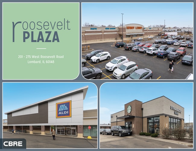
Property Record
201 W Roosevelt Rd, Lombard, IL 60148


Save to a Folder
{{folder.Name}}
{{folder.ListingIds.length}} Properties
{{folder.ListingIds.length}} Property
Create a New Folder
Property Detail
201 W Roosevelt Rd
06-19-201-021
ROOSEVELT PLAZA /EX TRI PCL DEDN FOR REBECCA RD BY 73-33871/ & /EX E 150.00 FT OF N 170.00 FT/
Commercialnec
DUPAGE
C
Illinois
B and X Area of moderate flood hazard, usually the area between the limits of the 100-year and 500-year floods.
1
2024
9.20 AC
2024
Eastern East/West Corr
844304
Chicago
124,712 SF
Chicago-Naperville-Elgin, IL-IN
NEARBY LISTINGS FOR SALE OR LEASE
DEMOGRAPHICS near 201 W Roosevelt Rd
1 mile
3 mile
5 mile
2025 Total Population
15,458
101,383
277,193
2030 Population
15,776
102,879
281,150
Pop Growth 2025-2030
+ 2.06%
+ 1.48%
+ 1.43%
Average Age
40
42
41
2025 Total Households
6,281
39,779
105,757
HH Growth 2025-2030
+ 2.24%
+ 1.66%
+ 1.52%
Median Household Inc
$92,882
$104,271
$109,297
Avg Household Size
2.40
2.50
2.50
2025 Avg HH Vehicles
2.00
2.00
2.00
Median Home Value
$323,013
$378,731
$402,540
Median Year Built
1973
1969
1970
Nearby Places
Map Layers
Map Styles
 Street
 Aerial
Layers
 Traffic
 Biking
Places
Listings with unknown addresses are not visible on the map
- Restaurants
- Banks
- Shops
- Fitness
- Groceries
PUBLIC TRANSPORTATION
COMMUTER RAIL
Lombard Station (Union Pacific West Line - Northeast Illinois Regional Commuter Railroad (Metra))
Drive
Walk
Distance
Lombard Station (Union Pacific West Line - Northeast Illinois Regional Commuter Railroad (Metra))
7 min
2.5 mi
Glen Ellyn Station (Union Pacific West Line - Northeast Illinois Regional Commuter Railroad (Metra))
Drive
Walk
Distance
Glen Ellyn Station (Union Pacific West Line - Northeast Illinois Regional Commuter Railroad (Metra))
12 min
3.9 mi
AIRPORT
Chicago O'Hare International
Drive
Walk
Distance
Chicago O'Hare International
30 min
20.4 mi
Chicago Midway International
Drive
Walk
Distance
Chicago Midway International
35 min
22.0 mi
Freight Ports
Port of Baltimore
Drive
Walk
Distance
Port of Baltimore
1 min
625.4 mi
SALE & LEASE HISTORY
LISTING DATE
SALE/LEASE

Nov 07, 2023
For Lease
Jun 07, 2017
For Sale
Jan 21, 2026
For Sale
Dec 16, 2024
For Sale
Nearby Properties
Address
Land Use
TOTAL SIZE
Lot Size
Zoning
Address
Land Use
TOTAL SIZE
Lot Size
Zoning
365,658 SF
5 AC
C
Address
Land Use
TOTAL SIZE
Lot Size
Zoning
834,293 SF
40.24 AC
M
Address
Land Use
TOTAL SIZE
Lot Size
Zoning
368,004 SF
5.95 AC
C
Address
Land Use
TOTAL SIZE
Lot Size
Zoning
534,583 SF
16.04 AC
C
Address
Land Use
TOTAL SIZE
Lot Size
Zoning
376,629 SF
16.26 AC
C
Address
Land Use
TOTAL SIZE
Lot Size
Zoning
12.21 AC
Address
Land Use
TOTAL SIZE
Lot Size
Zoning
338,664 SF
11.42 AC
M
Address
Land Use
TOTAL SIZE
Lot Size
Zoning
227,285 SF
1.75 AC
Address
Land Use
TOTAL SIZE
Lot Size
Zoning
313,920 SF
13.18 AC
M
Address
Land Use
TOTAL SIZE
Lot Size
Zoning
192,397 SF
20.01 AC
C
Address
Land Use
TOTAL SIZE
Lot Size
Zoning
319,650 SF
20.12 AC
M
Address
Land Use
TOTAL SIZE
Lot Size
Zoning
317,925 SF
7.10 AC
M
Address
Land Use
TOTAL SIZE
Lot Size
Zoning
200,237 SF
2.98 AC
C
Address
Land Use
TOTAL SIZE
Lot Size
Zoning
552,111 SF
4.48 AC
C
Address
Land Use
TOTAL SIZE
Lot Size
Zoning
239,756 SF
13.43 AC
M
Address
Land Use
TOTAL SIZE
Lot Size
Zoning
299,435 SF
11.16 AC
C
Address
Land Use
TOTAL SIZE
Lot Size
Zoning
252,596 SF
3.67 AC
C
Address
Land Use
TOTAL SIZE
Lot Size
Zoning
274,991 SF
14.07 AC
C
Address
Land Use
TOTAL SIZE
Lot Size
Zoning
312,210 SF
9.74 AC
C
Address
Land Use
TOTAL SIZE
Lot Size
Zoning
11.15 AC
M
Address
Land Use
TOTAL SIZE
Lot Size
Zoning
563,894 SF
9.69 AC
Address
Land Use
TOTAL SIZE
Lot Size
Zoning
102,314 SF
4.16 AC
R
Address
Land Use
TOTAL SIZE
Lot Size
Zoning
304,092 SF
3.67 AC
C
Address
Land Use
TOTAL SIZE
Lot Size
Zoning
176,923 SF
9.22 AC
C
Address
Land Use
TOTAL SIZE
Lot Size
Zoning
438,818 SF
5.90 AC
Address
Land Use
TOTAL SIZE
Lot Size
Zoning
220,900 SF
11.48 AC
M
Address
Land Use
TOTAL SIZE
Lot Size
Zoning
190,058 SF
11.77 AC
Address
Land Use
TOTAL SIZE
Lot Size
Zoning
235,203 SF
1.28 AC
Address
Land Use
TOTAL SIZE
Lot Size
Zoning
354,364 SF
9.63 AC
C
Address
Land Use
TOTAL SIZE
Lot Size
Zoning
291,840 SF
14.34 AC
The World's #1 Commercial Real Estate Marketplace
Connect with us
© 2026 CoStar Group
The information above has been obtained from sources believed reliable. While we do not doubt its accuracy we have not verified it and make no guarantee, warranty or representation about it. It is your responsibility to independently confirm its accuracy and completeness. Any projections, opinions, assumptions, or estimates used are for example only and do not represent the current or future performance of the property. The value of this transaction to you depends on tax and other factors which should be evaluated by your tax, financial, and legal advisors. You and your advisors should conduct a careful, independent investigation of the property to determine to your satisfaction the suitability of the property for your needs.