Property Record
201 Waterfront St, Oxon Hill, MD 20745
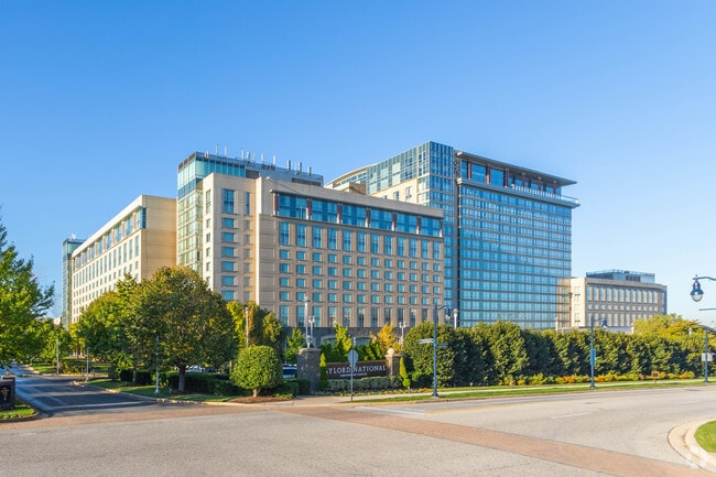

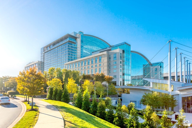
Property Detail
201 Waterfront St
12-3647492
PT PAR 1 -RESRCHD06
Auditorium
Prince Georges
RR
Maryland
AE The base floodplain where base flood elevations are provided. AE Zones are now used on new format FIRMs instead of A1-A30 Zones.
1
2024
22.78 AC
2025
Maryland South/East
801404
Washington, DC
2,308,874 SF
Washington-Arlington-Alexandria, DC-VA-MD-WV
NEARBY LISTINGS FOR SALE OR LEASE
DEMOGRAPHICS near 201 Waterfront St
1 mile
3 mile
5 mile
2025 Total Population
7,981
85,315
305,845
2030 Population
8,188
87,280
313,793
Pop Growth 2025-2030
+ 2.59%
+ 2.30%
+ 2.60%
Average Age
44
42
40
2025 Total Households
3,266
38,538
124,959
HH Growth 2025-2030
+ 2.91%
+ 2.58%
+ 2.90%
Median Household Inc
$136,122
$108,752
$106,151
Avg Household Size
2.40
2.20
2.40
2025 Avg HH Vehicles
2.00
2.00
2.00
Median Home Value
$497,469
$512,813
$582,981
Median Year Built
1991
1974
1973
Nearby Places
Map Layers
Map Styles
 Street
 Aerial
Layers
 Traffic
 Biking
Places
Listings with unknown addresses are not visible on the map
- Restaurants
- Banks
- Shops
- Fitness
- Groceries
PUBLIC TRANSPORTATION
COMMUTER RAIL
1 (Fredericksburg Line - Virginia Railway Express, Manassas Line - Virginia Railway Express)
Drive
Walk
Distance
1 (Fredericksburg Line - Virginia Railway Express, Manassas Line - Virginia Railway Express)
11 min
6.2 mi
Alexandria (Fredericksburg Line - Virginia Railway Express, Manassas Line - Virginia Railway Express)
Drive
Walk
Distance
Alexandria (Fredericksburg Line - Virginia Railway Express, Manassas Line - Virginia Railway Express)
11 min
6.2 mi
AIRPORT
Ronald Reagan Washington Ntl
Drive
Walk
Distance
Ronald Reagan Washington Ntl
22 min
8.9 mi
Washington Dulles International
Drive
Walk
Distance
Washington Dulles International
57 min
36.8 mi
Freight Ports
Port of Baltimore
Drive
Walk
Distance
Port of Baltimore
69 min
44.8 mi
Nearby Properties
Address
Land Use
TOTAL SIZE
Lot Size
Zoning
Address
Land Use
TOTAL SIZE
Lot Size
Zoning
1,241,298 SF
11.53 AC
RTOLE
Address
Land Use
TOTAL SIZE
Lot Size
Zoning
1,719,751 SF
39.48 AC
PDR-3;UNZO
Address
Land Use
TOTAL SIZE
Lot Size
Zoning
1,931,127 SF
11.53 AC
RTOLE
Address
Land Use
TOTAL SIZE
Lot Size
Zoning
1,278,930 SF
28.17 AC
350
Address
Land Use
TOTAL SIZE
Lot Size
Zoning
360,007 SF
35.80 AC
UT
Address
Land Use
TOTAL SIZE
Lot Size
Zoning
1,178,900 SF
4.67 AC
CDD#1
Address
Land Use
TOTAL SIZE
Lot Size
Zoning
445,727 SF
12.82 AC
RC
Address
Land Use
TOTAL SIZE
Lot Size
Zoning
288,675 SF
2 AC
RM
Address
Land Use
TOTAL SIZE
Lot Size
Zoning
556,384 SF
2.59 AC
CRMU/H
Address
Land Use
TOTAL SIZE
Lot Size
Zoning
1,000,000 SF
84 AC
UNZONED
Address
Land Use
TOTAL SIZE
Lot Size
Zoning
373,996 SF
37.74 AC
IE
Address
Land Use
TOTAL SIZE
Lot Size
Zoning
358,188 SF
2.44 AC
CDD#1
Address
Land Use
TOTAL SIZE
Lot Size
Zoning
1.43 AC
CDD#1
Address
Land Use
TOTAL SIZE
Lot Size
Zoning
7.73 AC
OCM(100)
Address
Land Use
TOTAL SIZE
Lot Size
Zoning
454,720 SF
11.52 AC
RC
Address
Land Use
TOTAL SIZE
Lot Size
Zoning
430,968 SF
1.85 AC
CDD#11
Address
Land Use
TOTAL SIZE
Lot Size
Zoning
352,103 SF
10.17 AC
230
Address
Land Use
TOTAL SIZE
Lot Size
Zoning
1.14 AC
CDD#1
Address
Land Use
TOTAL SIZE
Lot Size
Zoning
404,775 SF
1.31 AC
CDD#1
Address
Land Use
TOTAL SIZE
Lot Size
Zoning
447,751 SF
1.32 AC
CDD#1
Address
Land Use
TOTAL SIZE
Lot Size
Zoning
54.40 AC
WPR
Address
Land Use
TOTAL SIZE
Lot Size
Zoning
374,097 SF
36.22 AC
NAC
Address
Land Use
TOTAL SIZE
Lot Size
Zoning
587,628 SF
3.18 AC
RTOLC
Address
Land Use
TOTAL SIZE
Lot Size
Zoning
6.11 AC
UT
Address
Land Use
TOTAL SIZE
Lot Size
Zoning
312,500 SF
1.27 AC
OCH
Address
Land Use
TOTAL SIZE
Lot Size
Zoning
234,226 SF
8.86 AC
OCM(100)
Address
Land Use
TOTAL SIZE
Lot Size
Zoning
171,939 SF
10.28 AC
RB
Address
Land Use
TOTAL SIZE
Lot Size
Zoning
329,841 SF
2 AC
CRMU/H
Address
Land Use
TOTAL SIZE
Lot Size
Zoning
380 SF
17.44 AC
RMF20
The World's #1 Commercial Real Estate Marketplace
Connect with us
© 2026 CoStar Group
The information above has been obtained from sources believed reliable. While we do not doubt its accuracy we have not verified it and make no guarantee, warranty or representation about it. It is your responsibility to independently confirm its accuracy and completeness. Any projections, opinions, assumptions, or estimates used are for example only and do not represent the current or future performance of the property. The value of this transaction to you depends on tax and other factors which should be evaluated by your tax, financial, and legal advisors. You and your advisors should conduct a careful, independent investigation of the property to determine to your satisfaction the suitability of the property for your needs.