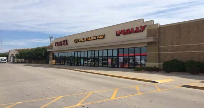
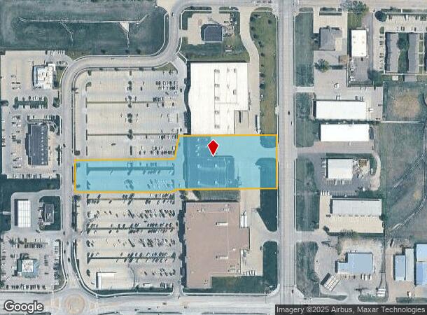
Property Record
201 Wilmar Ave, Grand Island, NE 68803

NEARBY LISTINGS FOR SALE OR LEASE
Property Detail
201 Wilmar Ave
Grand Island, NE
Martins Fourth Subdivision
400424274
MARTIN'S FOURTH SUB LT 1; MAP NUMBER: 3315-00-0-13288-000-0001
Storebuilding
Hall
X
Nebraska
31079C0167D
1
2024
3.55 AC
2025
I-80 Corridor
000700
Other Market Areas
34,988 SF
DEMOGRAPHICS near 201 Wilmar Ave
1 Mile
3 Mile
5 Mile
2024 Total Population
5,309
51,955
55,975
2029 Population
5,213
51,269
55,223
Pop Growth 2024-2029
(1.81%)
(1.32%)
(1.34%)
Average Age
39
37
38
2024 Total Households
2,109
19,701
21,126
HH Growth 2024-2029
(1.80%)
(1.33%)
(1.36%)
Median Household Inc
$58,524
$60,773
$61,732
Avg Household Size
2.40
2.50
2.50
2024 Avg HH Vehicles
2.00
2.00
2.00
Median Home Value
$174,007
$174,084
$175,155
Median Year Built
1971
1973
1974
Nearby Places
Map Layers
Map Styles
 Street
 Aerial
- Restaurants
- Banks
- Shops
- Fitness
- Groceries
PUBLIC TRANSPORTATION
AIRPORT
Central Nebraska Regional
DRIVE
WALK
Distance
Central Nebraska Regional
12 min
7.1 mi
Freight Ports
Tulsa Port Of Catoosa
DRIVE
WALK
Distance
Tulsa Port Of Catoosa
496 min
467.8 mi
Nearby Properties
Address
Land Use
TOTAL SIZE
Lot Size
Zoning
Address
Land Use
TOTAL SIZE
Lot Size
Zoning
80,974 SF
14.13 AC
03-COMMERC
Address
Land Use
TOTAL SIZE
Lot Size
Zoning
8,960 SF
0.36 AC
03-COMMERC
Address
Land Use
TOTAL SIZE
Lot Size
Zoning
66,294 SF
4.55 AC
03-COMMERC
Address
Land Use
TOTAL SIZE
Lot Size
Zoning
6 SF
13.46 AC
03-COMMERC
Address
Land Use
TOTAL SIZE
Lot Size
Zoning
3,776 SF
6.98 AC
03-COMMERC
Address
Land Use
TOTAL SIZE
Lot Size
Zoning
30,120 SF
9.30 AC
04-INDUSTR
Address
Land Use
TOTAL SIZE
Lot Size
Zoning
205,484 SF
22.31 AC
03-COMMERC
Address
Land Use
TOTAL SIZE
Lot Size
Zoning
83,804 SF
2.70 AC
03-COMMERC
Address
Land Use
TOTAL SIZE
Lot Size
Zoning
25,760 SF
32.07 AC
03-COMMERC
Address
Land Use
TOTAL SIZE
Lot Size
Zoning
6,800 SF
13.38 AC
04-INDUSTR
Address
Land Use
TOTAL SIZE
Lot Size
Zoning
68,240 SF
7.59 AC
03-COMMERC
Address
Land Use
TOTAL SIZE
Lot Size
Zoning
5,000 SF
10.57 AC
04-INDUSTR
Address
Land Use
TOTAL SIZE
Lot Size
Zoning
42,900 SF
16.96 AC
03-COMMERC
Address
Land Use
TOTAL SIZE
Lot Size
Zoning
131,800 SF
20.57 AC
03-COMMERC
Address
Land Use
TOTAL SIZE
Lot Size
Zoning
4,338 SF
6.96 AC
04-INDUSTR
Address
Land Use
TOTAL SIZE
Lot Size
Zoning
108,990 SF
1 AC
04-INDUSTR
Address
Land Use
TOTAL SIZE
Lot Size
Zoning
2,343 SF
12.26 AC
03-COMMERC
Address
Land Use
TOTAL SIZE
Lot Size
Zoning
13,960 SF
6.06 AC
03-COMMERC
Address
Land Use
TOTAL SIZE
Lot Size
Zoning
6,466 SF
8.99 AC
03-COMMERC
Address
Land Use
TOTAL SIZE
Lot Size
Zoning
73,016 SF
2.31 AC
03-COMMERC
Address
Land Use
TOTAL SIZE
Lot Size
Zoning
0.02 AC
03-COMMERC
Address
Land Use
TOTAL SIZE
Lot Size
Zoning
83,763 SF
8.39 AC
03-COMMERC
Address
Land Use
TOTAL SIZE
Lot Size
Zoning
46,170 SF
2.13 AC
03-COMMERC
Address
Land Use
TOTAL SIZE
Lot Size
Zoning
60,756 SF
1.31 AC
03-COMMERC
Address
Land Use
TOTAL SIZE
Lot Size
Zoning
78,228 SF
3.91 AC
03-COMMERC
Address
Land Use
TOTAL SIZE
Lot Size
Zoning
68,378 SF
1.74 AC
03-COMMERC
Address
Land Use
TOTAL SIZE
Lot Size
Zoning
76,749 SF
8.39 AC
03-COMMERC
Address
Land Use
TOTAL SIZE
Lot Size
Zoning
94,482 SF
10.88 AC
05-AGRICUL
Address
Land Use
TOTAL SIZE
Lot Size
Zoning
73,512 SF
8.49 AC
03-COMMERC
Address
Land Use
TOTAL SIZE
Lot Size
Zoning
3,640 SF
8.62 AC
COMMERCIAL
The World's #1 Commercial Real Estate Marketplace
Connect with us
© 2026 CoStar Group
The information above has been obtained from sources believed reliable. While we do not doubt its accuracy we have not verified it and make no guarantee, warranty or representation about it. It is your responsibility to independently confirm its accuracy and completeness. Any projections, opinions, assumptions, or estimates used are for example only and do not represent the current or future performance of the property. The value of this transaction to you depends on tax and other factors which should be evaluated by your tax, financial, and legal advisors. You and your advisors should conduct a careful, independent investigation of the property to determine to your satisfaction the suitability of the property for your needs.