Property Record
201 Zelkova Ct Nw, Conover, NC 28613
NEARBY LISTINGS FOR SALE OR LEASE
Property Detail
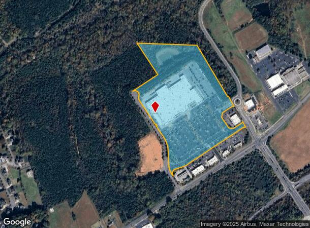
201 Zelkova Ct Nw
Hickory-Lenoir-Morganton, NC
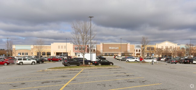
Wal-Mart Store 4224-00
3742103780980000
LOT 8 8 PL 65-62 WAL-MART PL 65-62
Storebuilding
Catawba
X
North Carolina
3710374200J
8
2024
28.33 AC
2025
Catawba County
010203
Charlotte
217,586 SF
DEMOGRAPHICS near 201 Zelkova Ct Nw
1 Mile
3 Mile
5 Mile
2024 Total Population
1,770
16,255
46,588
2029 Population
1,844
16,953
48,618
Pop Growth 2024-2029
+ 4.18%
+ 4.29%
+ 4.36%
Average Age
42
41
40
2024 Total Households
741
6,507
18,134
HH Growth 2024-2029
+ 4.18%
+ 4.16%
+ 4.28%
Median Household Inc
$47,352
$56,818
$55,220
Avg Household Size
2.40
2.40
2.50
2024 Avg HH Vehicles
2.00
2.00
2.00
Median Home Value
$219,104
$197,313
$174,413
Median Year Built
1991
1990
1984
Nearby Places
Map Layers
Map Styles
 Street
 Aerial
- Restaurants
- Banks
- Shops
- Fitness
- Groceries
Nearby Properties
Address
Land Use
TOTAL SIZE
Lot Size
Zoning
Address
Land Use
TOTAL SIZE
Lot Size
Zoning
502,665 SF
53.28 AC
EM-1-CD
Address
Land Use
TOTAL SIZE
Lot Size
Zoning
7,684 SF
11.85 AC
R-20-CD
Address
Land Use
TOTAL SIZE
Lot Size
Zoning
82,274 SF
19.77 AC
M-1-CD
Address
Land Use
TOTAL SIZE
Lot Size
Zoning
248,173 SF
53.73 AC
B-4
Address
Land Use
TOTAL SIZE
Lot Size
Zoning
30.63 AC
R-20
Address
Land Use
TOTAL SIZE
Lot Size
Zoning
4,700 SF
34.87 AC
COI
Address
Land Use
TOTAL SIZE
Lot Size
Zoning
150,498 SF
11.27 AC
M-1
Address
Land Use
TOTAL SIZE
Lot Size
Zoning
23,646 SF
79.60 AC
M-1
Address
Land Use
TOTAL SIZE
Lot Size
Zoning
9,064 SF
4.59 AC
B-2-CD
Address
Land Use
TOTAL SIZE
Lot Size
Zoning
283,942 SF
26.59 AC
M-1
Address
Land Use
TOTAL SIZE
Lot Size
Zoning
155,824 SF
27.77 AC
M-1
Address
Land Use
TOTAL SIZE
Lot Size
Zoning
67,085 SF
15.80 AC
PD-SC-M
Address
Land Use
TOTAL SIZE
Lot Size
Zoning
14,702 SF
363.28 AC
R-20
Address
Land Use
TOTAL SIZE
Lot Size
Zoning
354,727 SF
28.03 AC
M-1
Address
Land Use
TOTAL SIZE
Lot Size
Zoning
213,422 SF
33.51 AC
M-1
Address
Land Use
TOTAL SIZE
Lot Size
Zoning
637,521 SF
87.22 AC
M-1
Address
Land Use
TOTAL SIZE
Lot Size
Zoning
7,680 SF
9.22 AC
PD-H
Address
Land Use
TOTAL SIZE
Lot Size
Zoning
15.14 AC
NC
Address
Land Use
TOTAL SIZE
Lot Size
Zoning
20.90 AC
M-1
Address
Land Use
TOTAL SIZE
Lot Size
Zoning
318,757 SF
23.50 AC
M-1
Address
Land Use
TOTAL SIZE
Lot Size
Zoning
156,161 SF
17.22 AC
M-1
Address
Land Use
TOTAL SIZE
Lot Size
Zoning
34.80 AC
R-20
Address
Land Use
TOTAL SIZE
Lot Size
Zoning
249,849 SF
20.99 AC
M-1
Address
Land Use
TOTAL SIZE
Lot Size
Zoning
36,254 SF
13.18 AC
M-1
Address
Land Use
TOTAL SIZE
Lot Size
Zoning
132,516 SF
24.37 AC
M-1
Address
Land Use
TOTAL SIZE
Lot Size
Zoning
372,997 SF
31.17 AC
EM-1
Address
Land Use
TOTAL SIZE
Lot Size
Zoning
29,958 SF
2.09 AC
CC
Address
Land Use
TOTAL SIZE
Lot Size
Zoning
47,490 SF
34.43 AC
EM-1-CD
Address
Land Use
TOTAL SIZE
Lot Size
Zoning
142,720 SF
30.23 AC
M-1
The World's #1 Commercial Real Estate Marketplace
Connect with us
© 2026 CoStar Group
The information above has been obtained from sources believed reliable. While we do not doubt its accuracy we have not verified it and make no guarantee, warranty or representation about it. It is your responsibility to independently confirm its accuracy and completeness. Any projections, opinions, assumptions, or estimates used are for example only and do not represent the current or future performance of the property. The value of this transaction to you depends on tax and other factors which should be evaluated by your tax, financial, and legal advisors. You and your advisors should conduct a careful, independent investigation of the property to determine to your satisfaction the suitability of the property for your needs.