Property Record
2010 Bob Culvern Rd, Louisville, GA 30434
NEARBY LISTINGS FOR SALE OR LEASE
-
-
View all Louisville listings for sale on LoopNet.com
Property Detail
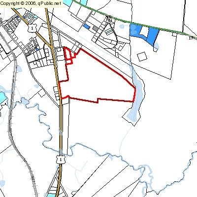
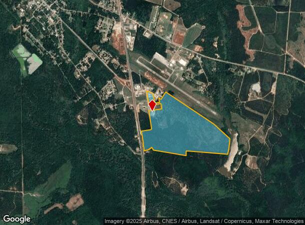
2010 Bob Culvern Rd
Governmentalpublicusegeneral
Jefferson
A
Georgia
13163C0335C
244.38 AC
0
Georgia South Area
2025
Other Market Areas
960300
0091-041
10,000 SF
DEMOGRAPHICS near 2010 Bob Culvern Rd
1 Mile
3 Mile
5 Mile
2024 Total Population
222
3,745
4,889
2029 Population
215
3,647
4,764
Pop Growth 2024-2029
(3.15%)
(2.62%)
(2.56%)
Average Age
40
41
42
2024 Total Households
87
1,379
1,829
HH Growth 2024-2029
(2.30%)
(2.39%)
(2.30%)
Median Household Inc
$44,852
$41,617
$42,694
Avg Household Size
2.60
2.40
2.40
2024 Avg HH Vehicles
2.00
2.00
2.00
Median Home Value
$99,999
$106,157
$106,479
Median Year Built
1983
1978
1981
Nearby Places
Map Layers
Map Styles
 Street
 Aerial
- Restaurants
- Banks
- Shops
- Fitness
- Groceries
Nearby Properties
Address
Land Use
TOTAL SIZE
Lot Size
Zoning
Address
Land Use
TOTAL SIZE
Lot Size
Zoning
79,442 SF
5.75 AC
R1A
Address
Land Use
TOTAL SIZE
Lot Size
Zoning
14,960 SF
2.50 AC
B1
Address
Land Use
TOTAL SIZE
Lot Size
Zoning
153.89 AC
RA
Address
Land Use
TOTAL SIZE
Lot Size
Zoning
16.48 AC
B2
Address
Land Use
TOTAL SIZE
Lot Size
Zoning
53,736 SF
9.59 AC
B2
Address
Land Use
TOTAL SIZE
Lot Size
Zoning
33,410 SF
4.40 AC
B2
Address
Land Use
TOTAL SIZE
Lot Size
Zoning
25,590 SF
8.45 AC
I
Address
Land Use
TOTAL SIZE
Lot Size
Zoning
24,872 SF
0.72 AC
B1
Address
Land Use
TOTAL SIZE
Lot Size
Zoning
17,325 SF
25.12 AC
RA
Address
Land Use
TOTAL SIZE
Lot Size
Zoning
12,566 SF
12.69 AC
RA
Address
Land Use
TOTAL SIZE
Lot Size
Zoning
1,551 SF
3.34 AC
B2
Address
Land Use
TOTAL SIZE
Lot Size
Zoning
1,192.40 AC
RA
Address
Land Use
TOTAL SIZE
Lot Size
Zoning
8,044 SF
6 AC
B2
Address
Land Use
TOTAL SIZE
Lot Size
Zoning
22.44 AC
R1A
Address
Land Use
TOTAL SIZE
Lot Size
Zoning
10,500 SF
1.72 AC
B2
Address
Land Use
TOTAL SIZE
Lot Size
Zoning
12,912 SF
0.54 AC
B1
Address
Land Use
TOTAL SIZE
Lot Size
Zoning
13,181 SF
16.68 AC
B2
Address
Land Use
TOTAL SIZE
Lot Size
Zoning
14,300 SF
2.95 AC
B2
Address
Land Use
TOTAL SIZE
Lot Size
Zoning
13,773 SF
6.08 AC
RA
Address
Land Use
TOTAL SIZE
Lot Size
Zoning
1,455 SF
4.28 AC
RA
Address
Land Use
TOTAL SIZE
Lot Size
Zoning
16,492 SF
2.28 AC
B2
Address
Land Use
TOTAL SIZE
Lot Size
Zoning
23,174 SF
1.95 AC
B2
Address
Land Use
TOTAL SIZE
Lot Size
Zoning
692.14 AC
RA
Address
Land Use
TOTAL SIZE
Lot Size
Zoning
2,391 SF
1.88 AC
B2
Address
Land Use
TOTAL SIZE
Lot Size
Zoning
5,305 SF
1.76 AC
B1
Address
Land Use
TOTAL SIZE
Lot Size
Zoning
3,122 SF
2.13 AC
B2
Address
Land Use
TOTAL SIZE
Lot Size
Zoning
246.93 AC
RA
Address
Land Use
TOTAL SIZE
Lot Size
Zoning
231.37 AC
RA
Address
Land Use
TOTAL SIZE
Lot Size
Zoning
4,992 SF
5 AC
R2
The World's #1 Commercial Real Estate Marketplace
Connect with us
© 2026 CoStar Group
The information above has been obtained from sources believed reliable. While we do not doubt its accuracy we have not verified it and make no guarantee, warranty or representation about it. It is your responsibility to independently confirm its accuracy and completeness. Any projections, opinions, assumptions, or estimates used are for example only and do not represent the current or future performance of the property. The value of this transaction to you depends on tax and other factors which should be evaluated by your tax, financial, and legal advisors. You and your advisors should conduct a careful, independent investigation of the property to determine to your satisfaction the suitability of the property for your needs.