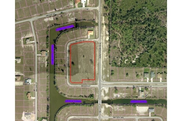
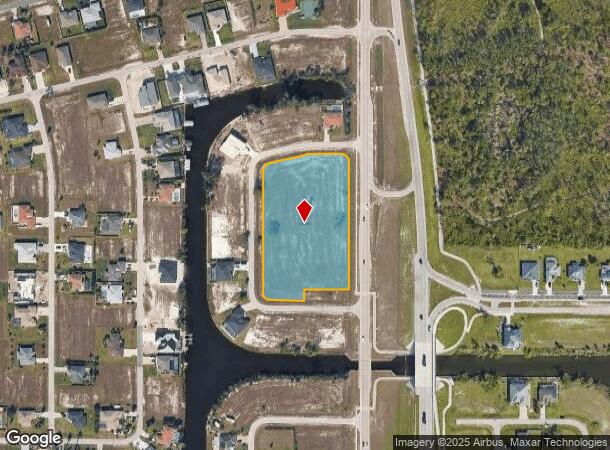
Property Record
2010 Burnt Store Rd N, Cape Coral, FL 33993

NEARBY LISTINGS FOR SALE OR LEASE
Property Detail
2010 Burnt Store Rd N
Cape Coral-Fort Myers, FL
Cape Coral
31-43-23-C2-04291.0130
CAPE CORAL UNIT 61 BLK 4291 PB 21 PG 15 LOTS 1 THRU 23 + N 5 OF LOT 24 + VAC ALLEY INST# 2007000296206
Commercialacreage
Lee
AE
Florida
12071C0233G
1-24
2024
3.30 AC
2025
Cape Coral
010111
Southwest Florida
DEMOGRAPHICS near 2010 Burnt Store Rd N
1 Mile
3 Mile
5 Mile
2024 Total Population
2,977
25,657
60,799
2029 Population
3,632
31,077
73,517
Pop Growth 2024-2029
+ 22.00%
+ 21.12%
+ 20.92%
Average Age
45
40
41
2024 Total Households
1,107
8,815
21,218
HH Growth 2024-2029
+ 21.68%
+ 20.79%
+ 20.53%
Median Household Inc
$65,206
$80,021
$75,918
Avg Household Size
2.60
2.80
2.80
2024 Avg HH Vehicles
2.00
2.00
2.00
Median Home Value
$356,319
$284,773
$277,910
Median Year Built
2008
2007
2006
Nearby Places
Map Layers
Map Styles
 Street
 Aerial
- Restaurants
- Banks
- Shops
- Fitness
- Groceries
PUBLIC TRANSPORTATION
AIRPORT
Punta Gorda
DRIVE
WALK
Distance
Punta Gorda
29 min
18.1 mi
Southwest Florida International
DRIVE
WALK
Distance
Southwest Florida International
46 min
28.9 mi
SALE & LEASE HISTORY
LISTING DATE
SALE/LEASE

Sep 24, 2016
For Sale
Nearby Properties
Address
Land Use
TOTAL SIZE
Lot Size
Zoning
Address
Land Use
TOTAL SIZE
Lot Size
Zoning
507,243 SF
115.38 AC
A
Address
Land Use
TOTAL SIZE
Lot Size
Zoning
670.48 AC
AG-2
Address
Land Use
TOTAL SIZE
Lot Size
Zoning
71,898 SF
98.60 AC
C1-D
Address
Land Use
TOTAL SIZE
Lot Size
Zoning
255.79 AC
AG-2
Address
Land Use
TOTAL SIZE
Lot Size
Zoning
228.33 AC
R1A
Address
Land Use
TOTAL SIZE
Lot Size
Zoning
78,740 SF
4.51 AC
C-1
Address
Land Use
TOTAL SIZE
Lot Size
Zoning
20.12 AC
RD
Address
Land Use
TOTAL SIZE
Lot Size
Zoning
48,402 SF
6.20 AC
Address
Land Use
TOTAL SIZE
Lot Size
Zoning
16.86 AC
RD
Address
Land Use
TOTAL SIZE
Lot Size
Zoning
113.70 AC
AG-2
Address
Land Use
TOTAL SIZE
Lot Size
Zoning
8,068 SF
1.10 AC
C-1
Address
Land Use
TOTAL SIZE
Lot Size
Zoning
3.87 AC
PRFLU
Address
Land Use
TOTAL SIZE
Lot Size
Zoning
6.73 AC
C-1
Address
Land Use
TOTAL SIZE
Lot Size
Zoning
3.34 AC
NC
Address
Land Use
TOTAL SIZE
Lot Size
Zoning
6,187 SF
1.13 AC
C1
Address
Land Use
TOTAL SIZE
Lot Size
Zoning
8,898 SF
2.95 AC
NC
Address
Land Use
TOTAL SIZE
Lot Size
Zoning
23,747 SF
178.18 AC
Address
Land Use
TOTAL SIZE
Lot Size
Zoning
157.25 AC
AG-2
Address
Land Use
TOTAL SIZE
Lot Size
Zoning
9,274 SF
1.20 AC
C1
Address
Land Use
TOTAL SIZE
Lot Size
Zoning
114.94 AC
NC
Address
Land Use
TOTAL SIZE
Lot Size
Zoning
19.27 AC
AG-2
Address
Land Use
TOTAL SIZE
Lot Size
Zoning
20.30 AC
RD-D
Address
Land Use
TOTAL SIZE
Lot Size
Zoning
102.92 AC
A
Address
Land Use
TOTAL SIZE
Lot Size
Zoning
19.05 AC
R1
Address
Land Use
TOTAL SIZE
Lot Size
Zoning
20.24 AC
AG-2
Address
Land Use
TOTAL SIZE
Lot Size
Zoning
38.18 AC
C1-D
Address
Land Use
TOTAL SIZE
Lot Size
Zoning
0.23 AC
R1-W
Address
Land Use
TOTAL SIZE
Lot Size
Zoning
15.83 AC
INS
Address
Land Use
TOTAL SIZE
Lot Size
Zoning
6,613 SF
1.18 AC
RD-W
Address
Land Use
TOTAL SIZE
Lot Size
Zoning
9.31 AC
RE
The World's #1 Commercial Real Estate Marketplace
Connect with us
© 2026 CoStar Group
The information above has been obtained from sources believed reliable. While we do not doubt its accuracy we have not verified it and make no guarantee, warranty or representation about it. It is your responsibility to independently confirm its accuracy and completeness. Any projections, opinions, assumptions, or estimates used are for example only and do not represent the current or future performance of the property. The value of this transaction to you depends on tax and other factors which should be evaluated by your tax, financial, and legal advisors. You and your advisors should conduct a careful, independent investigation of the property to determine to your satisfaction the suitability of the property for your needs.