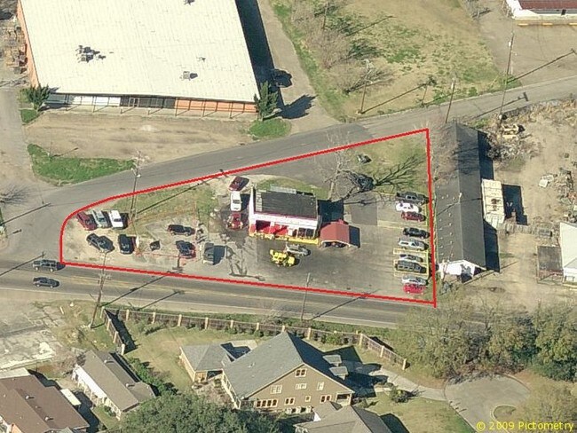
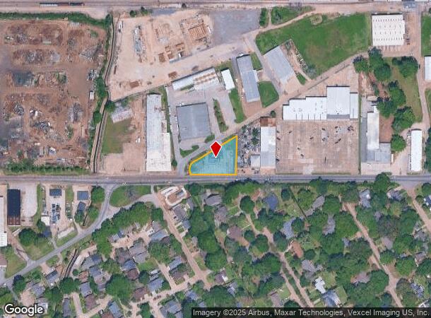
Property Record
2010 Cameron St, Lafayette, LA 70506
NEARBY LISTINGS FOR SALE OR LEASE
Property Detail
2010 Cameron St
Lafayette, LA
Shadyside Acres
6073098
P PLOT 1 SHADYSIDE ACRES SUB (271X68X212.5X 35) SEC 66 T9S R4E (212.50 X 126 X 247.1)(ABANDONED ROAD)
Warehouse
Lafayette
X
Louisiana
22055C0160J
1
2024
0.55 AC
2024
Greater Lafayette
000700
Lafayette
1,200 SF
DEMOGRAPHICS near 2010 Cameron St
1 Mile
3 Mile
5 Mile
2024 Total Population
10,647
65,797
125,448
2029 Population
11,267
69,909
133,215
Pop Growth 2024-2029
+ 5.82%
+ 6.25%
+ 6.19%
Average Age
39
39
39
2024 Total Households
4,128
28,271
53,851
HH Growth 2024-2029
+ 5.84%
+ 6.22%
+ 6.19%
Median Household Inc
$32,218
$36,020
$48,605
Avg Household Size
2.20
2.20
2.20
2024 Avg HH Vehicles
1.00
1.00
2.00
Median Home Value
$139,787
$159,213
$185,335
Median Year Built
1966
1973
1979
Nearby Places
Map Layers
Map Styles
 Street
 Aerial
- Restaurants
- Banks
- Shops
- Fitness
- Groceries
PUBLIC TRANSPORTATION
COMMUTER RAIL
Lafayette Amtrak Station (Sunset Limited - Amtrak)
DRIVE
WALK
Distance
Lafayette Amtrak Station (Sunset Limited - Amtrak)
4 min
1.9 mi
AIRPORT
Lafayette Regional/Paul Fournet Field
DRIVE
WALK
Distance
Lafayette Regional/Paul Fournet Field
9 min
4.3 mi
Freight Ports
Port of Iberia
DRIVE
WALK
Distance
Port of Iberia
34 min
25.2 mi
SALE & LEASE HISTORY
LISTING DATE
SALE/LEASE

Aug 29, 2024
For Sale
Nearby Properties
Address
Land Use
TOTAL SIZE
Lot Size
Zoning
Address
Land Use
TOTAL SIZE
Lot Size
Zoning
Address
Land Use
TOTAL SIZE
Lot Size
Zoning
Address
Land Use
TOTAL SIZE
Lot Size
Zoning
21.64 AC
Address
Land Use
TOTAL SIZE
Lot Size
Zoning
Address
Land Use
TOTAL SIZE
Lot Size
Zoning
4.20 AC
Address
Land Use
TOTAL SIZE
Lot Size
Zoning
28.09 AC
Address
Land Use
TOTAL SIZE
Lot Size
Zoning
273,675 SF
6.38 AC
Address
Land Use
TOTAL SIZE
Lot Size
Zoning
19.73 AC
Address
Land Use
TOTAL SIZE
Lot Size
Zoning
249,875 SF
29.76 AC
Address
Land Use
TOTAL SIZE
Lot Size
Zoning
90,725 SF
17.17 AC
Address
Land Use
TOTAL SIZE
Lot Size
Zoning
25.22 AC
Address
Land Use
TOTAL SIZE
Lot Size
Zoning
12.34 AC
Address
Land Use
TOTAL SIZE
Lot Size
Zoning
96.54 AC
Address
Land Use
TOTAL SIZE
Lot Size
Zoning
221,760 SF
0.67 AC
Address
Land Use
TOTAL SIZE
Lot Size
Zoning
0.92 AC
Address
Land Use
TOTAL SIZE
Lot Size
Zoning
182,700 SF
25.62 AC
Address
Land Use
TOTAL SIZE
Lot Size
Zoning
10.75 AC
Address
Land Use
TOTAL SIZE
Lot Size
Zoning
132,882 SF
13.98 AC
Address
Land Use
TOTAL SIZE
Lot Size
Zoning
423,600 SF
24.16 AC
Address
Land Use
TOTAL SIZE
Lot Size
Zoning
84,009 SF
6.90 AC
Address
Land Use
TOTAL SIZE
Lot Size
Zoning
47,249 SF
22.17 AC
Address
Land Use
TOTAL SIZE
Lot Size
Zoning
84,225 SF
Address
Land Use
TOTAL SIZE
Lot Size
Zoning
7.03 AC
Address
Land Use
TOTAL SIZE
Lot Size
Zoning
1.43 AC
Address
Land Use
TOTAL SIZE
Lot Size
Zoning
123,164 SF
2.11 AC
Address
Land Use
TOTAL SIZE
Lot Size
Zoning
7.77 AC
Address
Land Use
TOTAL SIZE
Lot Size
Zoning
87,868 SF
3.02 AC
Address
Land Use
TOTAL SIZE
Lot Size
Zoning
67,672 SF
10.18 AC
Address
Land Use
TOTAL SIZE
Lot Size
Zoning
120,500 SF
20 AC
Address
Land Use
TOTAL SIZE
Lot Size
Zoning
95,667 SF
4.30 AC
The World's #1 Commercial Real Estate Marketplace
Connect with us
© 2026 CoStar Group
The information above has been obtained from sources believed reliable. While we do not doubt its accuracy we have not verified it and make no guarantee, warranty or representation about it. It is your responsibility to independently confirm its accuracy and completeness. Any projections, opinions, assumptions, or estimates used are for example only and do not represent the current or future performance of the property. The value of this transaction to you depends on tax and other factors which should be evaluated by your tax, financial, and legal advisors. You and your advisors should conduct a careful, independent investigation of the property to determine to your satisfaction the suitability of the property for your needs.