Property Record
2010 E Main St, Lamoni, IA 50140


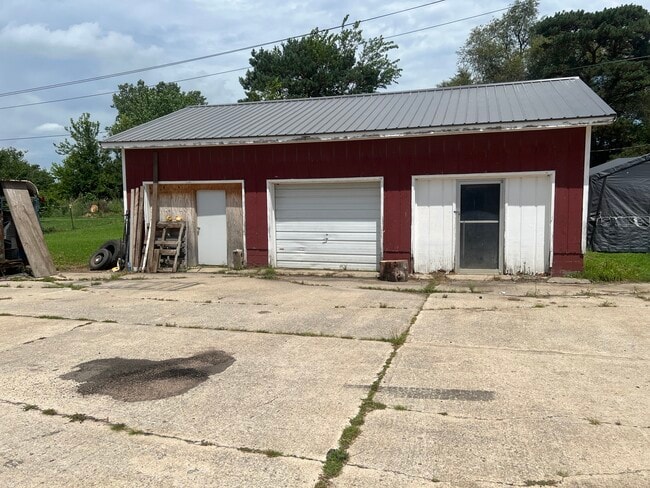
This Property Is For Sale
Property Detail
2010 E Main St
1406300013
06.67.26 PART OF PARCEL M, S 300' OF W 360' OF E 920' OF SW SW 6-67-26 LYING N OF HWY #69 LE SS S 80' FOR ROAD (1.82 ACRES TAXABLE) AND PART OF PARCE L M,N 56.5' OF S 356.5' OF W 360' OF E 920' OF SW SW 6-67-26 (.47 ACRES TAXABLE)
Multifamilydwelling
DECATUR
B and X Area of moderate flood hazard, usually the area between the limits of the 100-year and 500-year floods.
Iowa
2024
1.99 AC
2025
Iowa West Area
960200
Other Market Areas
16,016 SF
NEARBY LISTINGS FOR SALE OR LEASE
-
-
View all Lamoni listings for sale on LoopNet.com
DEMOGRAPHICS near 2010 E Main St
1 mile
3 mile
5 mile
2025 Total Population
65
2,258
2,729
2030 Population
64
2,242
2,704
Pop Growth 2025-2030
(1.54%)
(0.71%)
(0.92%)
Average Age
41
38
38
2025 Total Households
30
786
971
HH Growth 2025-2030
0.00%
(1.53%)
(1.65%)
Median Household Inc
$42,500
$52,808
$53,387
Avg Household Size
2.00
2.20
2.30
2025 Avg HH Vehicles
2.00
2.00
2.00
Median Home Value
$93,749
$124,675
$130,000
Median Year Built
1973
1971
1972
Nearby Places
Map Layers
Map Styles
 Street
 Aerial
Layers
 Traffic
 Biking
Places
Listings with unknown addresses are not visible on the map
- Restaurants
- Banks
- Shops
- Fitness
- Groceries
Nearby Properties
Address
Land Use
TOTAL SIZE
Lot Size
Zoning
Address
Land Use
TOTAL SIZE
Lot Size
Zoning
2,520 SF
7.77 AC
Address
Land Use
TOTAL SIZE
Lot Size
Zoning
17,042 SF
1.94 AC
Address
Land Use
TOTAL SIZE
Lot Size
Zoning
5,123 SF
1.92 AC
Address
Land Use
TOTAL SIZE
Lot Size
Zoning
9,360 SF
4.81 AC
Address
Land Use
TOTAL SIZE
Lot Size
Zoning
3,952 SF
0.56 AC
Address
Land Use
TOTAL SIZE
Lot Size
Zoning
34,470 SF
3.72 AC
Address
Land Use
TOTAL SIZE
Lot Size
Zoning
3,270 SF
1.06 AC
Address
Land Use
TOTAL SIZE
Lot Size
Zoning
10,500 SF
0.55 AC
Address
Land Use
TOTAL SIZE
Lot Size
Zoning
3,536 SF
0.89 AC
Address
Land Use
TOTAL SIZE
Lot Size
Zoning
58,792 SF
19.27 AC
Address
Land Use
TOTAL SIZE
Lot Size
Zoning
16,444 SF
4.96 AC
Address
Land Use
TOTAL SIZE
Lot Size
Zoning
25,988 SF
1.53 AC
Address
Land Use
TOTAL SIZE
Lot Size
Zoning
8,720 SF
13.21 AC
Address
Land Use
TOTAL SIZE
Lot Size
Zoning
67,500 SF
16 AC
Address
Land Use
TOTAL SIZE
Lot Size
Zoning
18,200 SF
1.17 AC
Address
Land Use
TOTAL SIZE
Lot Size
Zoning
7,160 SF
2.27 AC
Address
Land Use
TOTAL SIZE
Lot Size
Zoning
1,512 SF
0.53 AC
Address
Land Use
TOTAL SIZE
Lot Size
Zoning
4,160 SF
0.51 AC
Address
Land Use
TOTAL SIZE
Lot Size
Zoning
1,602 SF
0.86 AC
Address
Land Use
TOTAL SIZE
Lot Size
Zoning
8,640 SF
0.63 AC
Address
Land Use
TOTAL SIZE
Lot Size
Zoning
7,935 SF
12.14 AC
Address
Land Use
TOTAL SIZE
Lot Size
Zoning
8,000 SF
1 AC
Address
Land Use
TOTAL SIZE
Lot Size
Zoning
4,900 SF
2.88 AC
Address
Land Use
TOTAL SIZE
Lot Size
Zoning
15,756 SF
0.43 AC
Address
Land Use
TOTAL SIZE
Lot Size
Zoning
7,820 SF
1.20 AC
Address
Land Use
TOTAL SIZE
Lot Size
Zoning
3,723 SF
0.07 AC
Address
Land Use
TOTAL SIZE
Lot Size
Zoning
7,674 SF
2.60 AC
Address
Land Use
TOTAL SIZE
Lot Size
Zoning
7,380 SF
2.55 AC
Address
Land Use
TOTAL SIZE
Lot Size
Zoning
2,544 SF
0.72 AC
The World's #1 Commercial Real Estate Marketplace
Connect with us
© 2026 CoStar Group
The information above has been obtained from sources believed reliable. While we do not doubt its accuracy we have not verified it and make no guarantee, warranty or representation about it. It is your responsibility to independently confirm its accuracy and completeness. Any projections, opinions, assumptions, or estimates used are for example only and do not represent the current or future performance of the property. The value of this transaction to you depends on tax and other factors which should be evaluated by your tax, financial, and legal advisors. You and your advisors should conduct a careful, independent investigation of the property to determine to your satisfaction the suitability of the property for your needs.