Property Record
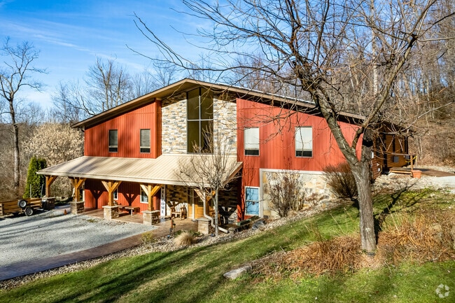
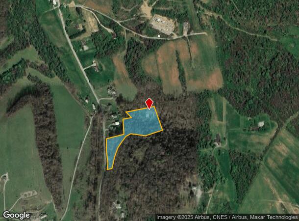
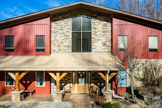
2010 Emerald Valley Rd, Vanderbilt, PA 15486
NEARBY LISTINGS FOR SALE OR LEASE
-
-
View all Vanderbilt listings for sale on LoopNet.com
Property Detail
2010 Emerald Valley Rd
09-11-0039
Sampey Subdivision
Commercialofficeresidentialmixeduse
3.69 AC BED & BREAKFAST
X
Fayette
42051C0195E
Pennsylvania
2025
3.69 AC
2025
Pittsburgh South Area
260900
Pittsburgh
7,368 SF
Pittsburgh, PA
DEMOGRAPHICS near 2010 Emerald Valley Rd
1 Mile
3 Mile
5 Mile
2024 Total Population
287
9,917
22,357
2029 Population
273
9,530
21,721
Pop Growth 2024-2029
(4.88%)
(3.90%)
(2.84%)
Average Age
45
44
44
2024 Total Households
121
4,317
9,653
HH Growth 2024-2029
(4.96%)
(4.10%)
(3.04%)
Median Household Inc
$45,417
$46,181
$47,485
Avg Household Size
2.20
2.20
2.30
2024 Avg HH Vehicles
2.00
2.00
2.00
Median Home Value
$154,687
$106,984
$116,229
Median Year Built
1954
1954
1954
Nearby Places
Map Layers
Map Styles
 Street
 Aerial
- Restaurants
- Banks
- Shops
- Fitness
- Groceries
PUBLIC TRANSPORTATION
COMMUTER RAIL
DRIVE
WALK
Distance
12 min
6.3 mi
AIRPORT
Arnold Palmer Regional
DRIVE
WALK
Distance
Arnold Palmer Regional
50 min
29.8 mi
SALE & LEASE HISTORY
LISTING DATE
SALE/LEASE

Sep 24, 2016
For Sale
Nearby Properties
Address
Land Use
TOTAL SIZE
Lot Size
Zoning
Address
Land Use
TOTAL SIZE
Lot Size
Zoning
24.40 AC
Address
Land Use
TOTAL SIZE
Lot Size
Zoning
23.88 AC
Address
Land Use
TOTAL SIZE
Lot Size
Zoning
Address
Land Use
TOTAL SIZE
Lot Size
Zoning
Address
Land Use
TOTAL SIZE
Lot Size
Zoning
Address
Land Use
TOTAL SIZE
Lot Size
Zoning
26,834 SF
17.17 AC
Address
Land Use
TOTAL SIZE
Lot Size
Zoning
69,630 SF
1 AC
Address
Land Use
TOTAL SIZE
Lot Size
Zoning
Address
Land Use
TOTAL SIZE
Lot Size
Zoning
9,558 SF
7.46 AC
Address
Land Use
TOTAL SIZE
Lot Size
Zoning
4,000 SF
5.04 AC
Address
Land Use
TOTAL SIZE
Lot Size
Zoning
9,816 SF
0.93 AC
Address
Land Use
TOTAL SIZE
Lot Size
Zoning
34,647 SF
2.79 AC
Address
Land Use
TOTAL SIZE
Lot Size
Zoning
Address
Land Use
TOTAL SIZE
Lot Size
Zoning
50,518 SF
4.65 AC
Address
Land Use
TOTAL SIZE
Lot Size
Zoning
0.42 AC
Address
Land Use
TOTAL SIZE
Lot Size
Zoning
0.35 AC
Address
Land Use
TOTAL SIZE
Lot Size
Zoning
3.39 AC
Address
Land Use
TOTAL SIZE
Lot Size
Zoning
12,000 SF
22.06 AC
Address
Land Use
TOTAL SIZE
Lot Size
Zoning
91,840 SF
33.60 AC
Address
Land Use
TOTAL SIZE
Lot Size
Zoning
Address
Land Use
TOTAL SIZE
Lot Size
Zoning
37,090 SF
54 AC
Address
Land Use
TOTAL SIZE
Lot Size
Zoning
11,505 SF
1.34 AC
Address
Land Use
TOTAL SIZE
Lot Size
Zoning
24.26 AC
Address
Land Use
TOTAL SIZE
Lot Size
Zoning
5,264 SF
1.32 AC
Address
Land Use
TOTAL SIZE
Lot Size
Zoning
17,612 SF
9.46 AC
Address
Land Use
TOTAL SIZE
Lot Size
Zoning
23,168 SF
0.90 AC
Address
Land Use
TOTAL SIZE
Lot Size
Zoning
1.78 AC
Address
Land Use
TOTAL SIZE
Lot Size
Zoning
49,230 SF
3.39 AC
Address
Land Use
TOTAL SIZE
Lot Size
Zoning
2,448 SF
77.24 AC
Address
Land Use
TOTAL SIZE
Lot Size
Zoning
2,470 SF
0.94 AC
The World's #1 Commercial Real Estate Marketplace
Connect with us
© 2025 CoStar Group
The information above has been obtained from sources believed reliable. While we do not doubt its accuracy we have not verified it and make no guarantee, warranty or representation about it. It is your responsibility to independently confirm its accuracy and completeness. Any projections, opinions, assumptions, or estimates used are for example only and do not represent the current or future performance of the property. The value of this transaction to you depends on tax and other factors which should be evaluated by your tax, financial, and legal advisors. You and your advisors should conduct a careful, independent investigation of the property to determine to your satisfaction the suitability of the property for your needs.