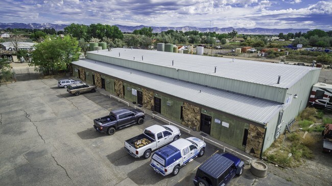
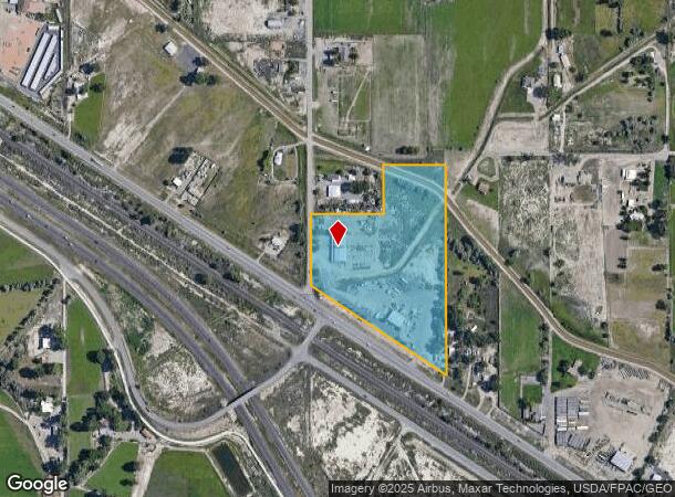
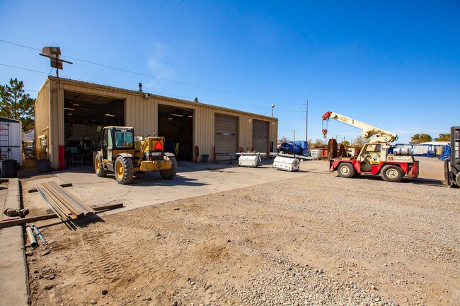
Property Record
2010 Highway 6 And 50, Fruita, CO 81521
NEARBY LISTINGS FOR SALE OR LEASE
Property Detail
2010 Highway 6 And 50
2697-262-00-016
W 45RD OF SW4NW4 SEC 26 1N 2W N OF HWY 6 & 50 EXC INDEPENDENT RANCHMANS DITCH + ALSO EXC BEG 40FT S & 30FT E OF NW COR SW4NW4 SD SEC 26 E 330FT S 230FT W 330FT N 230FT TO POB - APPROX 13.04AC
Multipleuses
Mesa
X
Colorado
08077C0445F
16
2023
3.15 AC
2024
Colorado Northwest Area
001502
Other Market Areas
16,450 SF
Grand Junction, CO
DEMOGRAPHICS near 2010 Highway 6 And 50
1 Mile
3 Mile
5 Mile
2024 Total Population
326
10,411
31,075
2029 Population
334
10,898
32,649
Pop Growth 2024-2029
+ 2.45%
+ 4.68%
+ 5.07%
Average Age
45
42
43
2024 Total Households
117
3,860
12,176
HH Growth 2024-2029
+ 2.56%
+ 4.69%
+ 5.12%
Median Household Inc
$108,035
$92,651
$84,417
Avg Household Size
2.70
2.70
2.50
2024 Avg HH Vehicles
3.00
2.00
2.00
Median Home Value
$689,189
$446,941
$421,369
Median Year Built
1988
1996
1996
Nearby Places
Map Layers
Map Styles
 Street
 Aerial
- Restaurants
- Banks
- Shops
- Fitness
- Groceries
PUBLIC TRANSPORTATION
COMMUTER RAIL
Grand Junction Amtrak Station (California Zephyr - Amtrak)
DRIVE
WALK
Distance
Grand Junction Amtrak Station (California Zephyr - Amtrak)
14 min
7.9 mi
AIRPORT
Grand Junction Regional
DRIVE
WALK
Distance
Grand Junction Regional
14 min
9.5 mi
Freight Ports
Port of Long Beach
DRIVE
WALK
Distance
Port of Long Beach
809 min
781.8 mi
SALE & LEASE HISTORY
LISTING DATE
SALE/LEASE

Sep 08, 2017
For Sale
Oct 26, 2019
For Sale
Nearby Properties
Address
Land Use
TOTAL SIZE
Lot Size
Zoning
Address
Land Use
TOTAL SIZE
Lot Size
Zoning
188,386 SF
39.06 AC
CSR
Address
Land Use
TOTAL SIZE
Lot Size
Zoning
97,809 SF
22.16 AC
Address
Land Use
TOTAL SIZE
Lot Size
Zoning
57,933 SF
10 AC
CSR
Address
Land Use
TOTAL SIZE
Lot Size
Zoning
80,543 SF
31.70 AC
AFT
Address
Land Use
TOTAL SIZE
Lot Size
Zoning
22,544 SF
10.87 AC
I-1
Address
Land Use
TOTAL SIZE
Lot Size
Zoning
41,645 SF
17.89 AC
I-1
Address
Land Use
TOTAL SIZE
Lot Size
Zoning
83,593 SF
4.33 AC
PD
Address
Land Use
TOTAL SIZE
Lot Size
Zoning
69,600 SF
5.72 AC
I-1
Address
Land Use
TOTAL SIZE
Lot Size
Zoning
12,400 SF
3,702.22 AC
C-2
Address
Land Use
TOTAL SIZE
Lot Size
Zoning
251,521 SF
0.02 AC
Address
Land Use
TOTAL SIZE
Lot Size
Zoning
27,000 SF
14.94 AC
GC
Address
Land Use
TOTAL SIZE
Lot Size
Zoning
7,720 SF
27.17 AC
PD
Address
Land Use
TOTAL SIZE
Lot Size
Zoning
34,330 SF
2.86 AC
I-1
Address
Land Use
TOTAL SIZE
Lot Size
Zoning
52,882 SF
6.03 AC
C-2
Address
Land Use
TOTAL SIZE
Lot Size
Zoning
34,686 SF
4.08 AC
I-1
Address
Land Use
TOTAL SIZE
Lot Size
Zoning
28,900 SF
4.70 AC
PD
Address
Land Use
TOTAL SIZE
Lot Size
Zoning
27,063 SF
3.49 AC
I-1
Address
Land Use
TOTAL SIZE
Lot Size
Zoning
26,732 SF
4.75 AC
Address
Land Use
TOTAL SIZE
Lot Size
Zoning
36,139 SF
2.25 AC
GC
Address
Land Use
TOTAL SIZE
Lot Size
Zoning
22,787 SF
9.45 AC
I-1
Address
Land Use
TOTAL SIZE
Lot Size
Zoning
19,707 SF
5.99 AC
I-1
Address
Land Use
TOTAL SIZE
Lot Size
Zoning
29,830 SF
5.85 AC
I-1
Address
Land Use
TOTAL SIZE
Lot Size
Zoning
21,174 SF
2.92 AC
I-1
Address
Land Use
TOTAL SIZE
Lot Size
Zoning
39,600 SF
4.60 AC
C-2
Address
Land Use
TOTAL SIZE
Lot Size
Zoning
22,500 SF
7.61 AC
PD
Address
Land Use
TOTAL SIZE
Lot Size
Zoning
37,620 SF
2.65 AC
I-1
Address
Land Use
TOTAL SIZE
Lot Size
Zoning
14,800 SF
3.81 AC
I-1
Address
Land Use
TOTAL SIZE
Lot Size
Zoning
24,500 SF
2.86 AC
I-1
Address
Land Use
TOTAL SIZE
Lot Size
Zoning
29,741 SF
2.66 AC
I-2
Address
Land Use
TOTAL SIZE
Lot Size
Zoning
28,599 SF
5 AC
I-1
The World's #1 Commercial Real Estate Marketplace
Connect with us
© 2025 CoStar Group
The information above has been obtained from sources believed reliable. While we do not doubt its accuracy we have not verified it and make no guarantee, warranty or representation about it. It is your responsibility to independently confirm its accuracy and completeness. Any projections, opinions, assumptions, or estimates used are for example only and do not represent the current or future performance of the property. The value of this transaction to you depends on tax and other factors which should be evaluated by your tax, financial, and legal advisors. You and your advisors should conduct a careful, independent investigation of the property to determine to your satisfaction the suitability of the property for your needs.