Property Record
2010 Jacobssen Dr, Normal, IL 61761
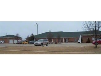

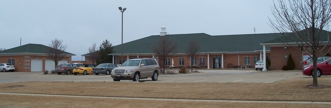
Property Detail
2010 Jacobssen Dr
Commercialnec
NAYAK BUILDING CONDOMINIUM UNITS A, B & C
C-1
McLean
B and X Area of moderate flood hazard, usually the area between the limits of the 100-year and 500-year floods.
Illinois
2022
1.20 AC
2022
Other Market Areas
000507
Bloomington, IL
13,240 SF
14-24-357-004
NEARBY LISTINGS FOR SALE OR LEASE
DEMOGRAPHICS near 2010 Jacobssen Dr
1 mile
3 mile
5 mile
2025 Total Population
6,798
64,705
117,974
2030 Population
6,772
64,697
118,239
Pop Growth 2025-2030
(0.38%)
(0.01%)
+ 0.22%
Average Age
38
36
37
2025 Total Households
2,617
24,956
48,102
HH Growth 2025-2030
(0.34%)
(0.03%)
+ 0.26%
Median Household Inc
$119,408
$86,427
$73,695
Avg Household Size
2.60
2.40
2.20
2025 Avg HH Vehicles
2.00
2.00
2.00
Median Home Value
$299,669
$248,171
$220,792
Median Year Built
1994
1989
1980
Nearby Places
Map Layers
Map Styles
 Street
 Aerial
Layers
 Traffic
 Biking
Places
Listings with unknown addresses are not visible on the map
- Restaurants
- Banks
- Shops
- Fitness
- Groceries
PUBLIC TRANSPORTATION
COMMUTER RAIL
Bloomington-Normal (Lincoln Service - Amtrak, Lincoln Service Missouri River Runner - Amtrak, Texas Eagle - Amtrak)
Drive
Walk
Distance
Bloomington-Normal (Lincoln Service - Amtrak, Lincoln Service Missouri River Runner - Amtrak, Texas Eagle - Amtrak)
7 min
2.9 mi
AIRPORT
Central Il Regional/Bloomington-Normal
Drive
Walk
Distance
Central Il Regional/Bloomington-Normal
11 min
4.1 mi
Freight Ports
Port Milwaukee
Drive
Walk
Distance
Port Milwaukee
238 min
203.6 mi
SALE & LEASE HISTORY
LISTING DATE
SALE/LEASE

Sep 23, 2016
For Sale
Nov 08, 2016
For Lease
Nearby Properties
Address
Land Use
TOTAL SIZE
Lot Size
Zoning
Address
Land Use
TOTAL SIZE
Lot Size
Zoning
562,852 SF
48.94 AC
Address
Land Use
TOTAL SIZE
Lot Size
Zoning
154,502 SF
1.25 AC
Address
Land Use
TOTAL SIZE
Lot Size
Zoning
445,676 SF
20.86 AC
Address
Land Use
TOTAL SIZE
Lot Size
Zoning
426,806 SF
20.93 AC
Address
Land Use
TOTAL SIZE
Lot Size
Zoning
127,569 SF
1.54 AC
Address
Land Use
TOTAL SIZE
Lot Size
Zoning
1,624,618 SF
54.32 AC
Address
Land Use
TOTAL SIZE
Lot Size
Zoning
414,270 SF
13.50 AC
Address
Land Use
TOTAL SIZE
Lot Size
Zoning
158,508 SF
3.13 AC
R1C
Address
Land Use
TOTAL SIZE
Lot Size
Zoning
177,365 SF
11.75 AC
Address
Land Use
TOTAL SIZE
Lot Size
Zoning
123,016 SF
18.52 AC
C-2
Address
Land Use
TOTAL SIZE
Lot Size
Zoning
513,218 SF
20.64 AC
R-3A
Address
Land Use
TOTAL SIZE
Lot Size
Zoning
136,382 SF
9.53 AC
Address
Land Use
TOTAL SIZE
Lot Size
Zoning
16.79 AC
Address
Land Use
TOTAL SIZE
Lot Size
Zoning
423,526 SF
25.35 AC
B-1
Address
Land Use
TOTAL SIZE
Lot Size
Zoning
208,876 SF
20.87 AC
B-1
Address
Land Use
TOTAL SIZE
Lot Size
Zoning
180,144 SF
8.95 AC
Address
Land Use
TOTAL SIZE
Lot Size
Zoning
122,112 SF
7.16 AC
Address
Land Use
TOTAL SIZE
Lot Size
Zoning
276,695 SF
12.68 AC
Address
Land Use
TOTAL SIZE
Lot Size
Zoning
281,134 SF
8.04 AC
R-3A
Address
Land Use
TOTAL SIZE
Lot Size
Zoning
28,953 SF
1 AC
Address
Land Use
TOTAL SIZE
Lot Size
Zoning
231,077 SF
15.49 AC
Address
Land Use
TOTAL SIZE
Lot Size
Zoning
197,766 SF
13.86 AC
Address
Land Use
TOTAL SIZE
Lot Size
Zoning
83.87 AC
Address
Land Use
TOTAL SIZE
Lot Size
Zoning
295,802 SF
14.99 AC
Address
Land Use
TOTAL SIZE
Lot Size
Zoning
3.82 AC
B-1
Address
Land Use
TOTAL SIZE
Lot Size
Zoning
141,694 SF
5.75 AC
Address
Land Use
TOTAL SIZE
Lot Size
Zoning
139,324 SF
15.78 AC
B-1
Address
Land Use
TOTAL SIZE
Lot Size
Zoning
127,720 SF
1.68 AC
R-1C
Address
Land Use
TOTAL SIZE
Lot Size
Zoning
62,551 SF
0.42 AC
B-2
The World's #1 Commercial Real Estate Marketplace
Connect with us
© 2026 CoStar Group
The information above has been obtained from sources believed reliable. While we do not doubt its accuracy we have not verified it and make no guarantee, warranty or representation about it. It is your responsibility to independently confirm its accuracy and completeness. Any projections, opinions, assumptions, or estimates used are for example only and do not represent the current or future performance of the property. The value of this transaction to you depends on tax and other factors which should be evaluated by your tax, financial, and legal advisors. You and your advisors should conduct a careful, independent investigation of the property to determine to your satisfaction the suitability of the property for your needs.