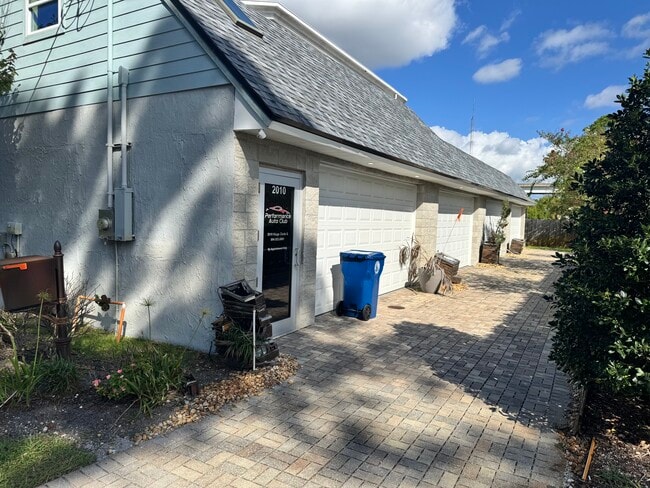
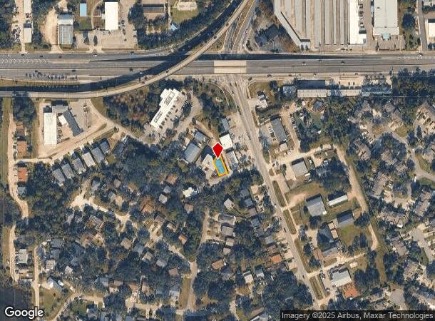
Property Record
2010 Kings Cir S, Neptune Beach, FL 32266
Current Lease Availabilities
NEARBY LISTINGS FOR SALE OR LEASE
Property Detail
2010 Kings Cir S
Jacksonville, FL
Fla Bch Plat 2 Prado Ferr
173305-0000
11-61 38-2S-29E FLA BEACH PLAT 2 PRADO FERRER LOTS 28,29 BLK 2
Vehiclerentalsvehiclesales
Duval
X
Florida
12031C0408J
28,29
2024
0.07 AC
2025
Beaches
014002
Jacksonville (Florida)
2,448 SF
DEMOGRAPHICS near 2010 Kings Cir S
1 Mile
3 Mile
5 Mile
2024 Total Population
7,169
63,867
138,883
2029 Population
7,388
66,839
145,244
Pop Growth 2024-2029
+ 3.05%
+ 4.65%
+ 4.58%
Average Age
41
42
40
2024 Total Households
3,067
27,850
57,217
HH Growth 2024-2029
+ 3.16%
+ 4.91%
+ 4.79%
Median Household Inc
$86,688
$88,030
$90,890
Avg Household Size
2.30
2.30
2.30
2024 Avg HH Vehicles
2.00
2.00
2.00
Median Home Value
$367,222
$394,296
$376,501
Median Year Built
1980
1986
1992
Nearby Places
- Restaurants
- Banks
- Shops
- Fitness
- Groceries
PUBLIC TRANSPORTATION
AIRPORT
Jacksonville International
DRIVE
WALK
Distance
Jacksonville International
39 min
24.6 mi
Freight Ports
Jacksonville Port
DRIVE
WALK
Distance
Jacksonville Port
29 min
16.2 mi
Nearby Properties
Address
Land Use
TOTAL SIZE
Lot Size
Zoning
Address
Land Use
TOTAL SIZE
Lot Size
Zoning
240,363 SF
24.71 AC
PUD
Address
Land Use
TOTAL SIZE
Lot Size
Zoning
246,985 SF
14.01 AC
PUD
Address
Land Use
TOTAL SIZE
Lot Size
Zoning
377,617 SF
23.38 AC
PUD
Address
Land Use
TOTAL SIZE
Lot Size
Zoning
178,884 SF
12.54 AC
PUD
Address
Land Use
TOTAL SIZE
Lot Size
Zoning
194,953 SF
22.43 AC
PUD
Address
Land Use
TOTAL SIZE
Lot Size
Zoning
696,126 SF
70.05 AC
APUD
Address
Land Use
TOTAL SIZE
Lot Size
Zoning
389,030 SF
26.39 AC
PUD
Address
Land Use
TOTAL SIZE
Lot Size
Zoning
395,677 SF
45.86 AC
PUD
Address
Land Use
TOTAL SIZE
Lot Size
Zoning
235,939 SF
11.25 AC
JRM-1
Address
Land Use
TOTAL SIZE
Lot Size
Zoning
404,896 SF
36.51 AC
PUD
Address
Land Use
TOTAL SIZE
Lot Size
Zoning
302,329 SF
28.90 AC
PUD
Address
Land Use
TOTAL SIZE
Lot Size
Zoning
115,119 SF
1.14 AC
JRD
Address
Land Use
TOTAL SIZE
Lot Size
Zoning
50,124 SF
2.53 AC
JRM-2
Address
Land Use
TOTAL SIZE
Lot Size
Zoning
90,729 SF
0.99 AC
JRD
Address
Land Use
TOTAL SIZE
Lot Size
Zoning
65,384 SF
2.33 AC
ACG
Address
Land Use
TOTAL SIZE
Lot Size
Zoning
44,526 SF
1.98 AC
JRM-2
Address
Land Use
TOTAL SIZE
Lot Size
Zoning
265,386 SF
29.35 AC
RMD-C
Address
Land Use
TOTAL SIZE
Lot Size
Zoning
206,990 SF
15.76 AC
RMD-D
Address
Land Use
TOTAL SIZE
Lot Size
Zoning
244,454 SF
14.76 AC
NR-5
Address
Land Use
TOTAL SIZE
Lot Size
Zoning
185,402 SF
14.03 AC
RMD-C
Address
Land Use
TOTAL SIZE
Lot Size
Zoning
157,942 SF
15.55 AC
PUD
Address
Land Use
TOTAL SIZE
Lot Size
Zoning
171,440 SF
11.15 AC
PUD
Address
Land Use
TOTAL SIZE
Lot Size
Zoning
219,659 SF
21.37 AC
NR-1
Address
Land Use
TOTAL SIZE
Lot Size
Zoning
26,510 SF
1.36 AC
JCBD
Address
Land Use
TOTAL SIZE
Lot Size
Zoning
120,233 SF
14.08 AC
ACG
Address
Land Use
TOTAL SIZE
Lot Size
Zoning
167,476 SF
12.89 AC
RMD-C
Address
Land Use
TOTAL SIZE
Lot Size
Zoning
183,674 SF
22.19 AC
PUD
Address
Land Use
TOTAL SIZE
Lot Size
Zoning
248,601 SF
43.01 AC
PBF-1
Address
Land Use
TOTAL SIZE
Lot Size
Zoning
122,836 SF
26.31 AC
JPUD
Address
Land Use
TOTAL SIZE
Lot Size
Zoning
136,558 SF
1.89 AC
JC-2
The World's #1 Commercial Real Estate Marketplace
Connect with us
© 2025 CoStar Group
The information above has been obtained from sources believed reliable. While we do not doubt its accuracy we have not verified it and make no guarantee, warranty or representation about it. It is your responsibility to independently confirm its accuracy and completeness. Any projections, opinions, assumptions, or estimates used are for example only and do not represent the current or future performance of the property. The value of this transaction to you depends on tax and other factors which should be evaluated by your tax, financial, and legal advisors. You and your advisors should conduct a careful, independent investigation of the property to determine to your satisfaction the suitability of the property for your needs.