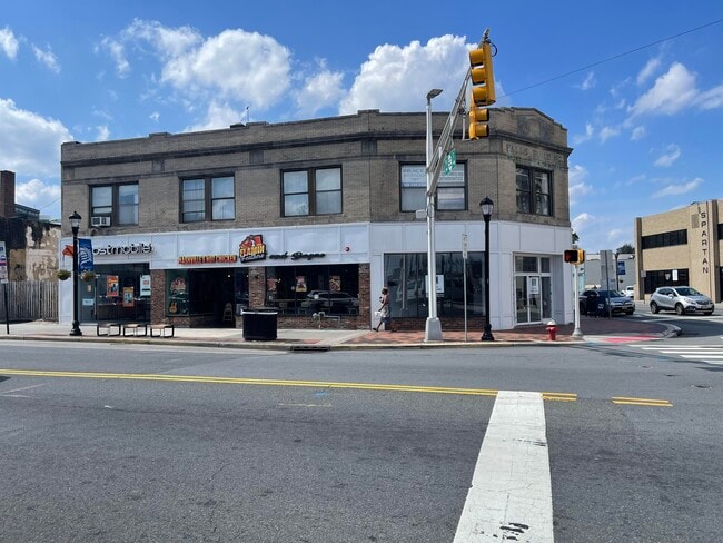
Property Record
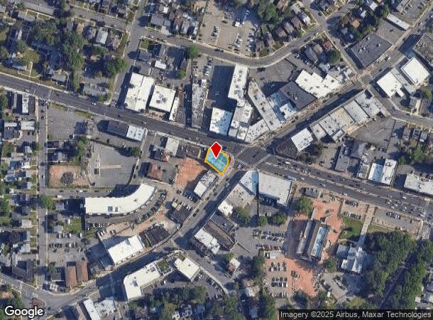
2010 Morris Ave, Union, NJ 07083

Current Lease Availabilities
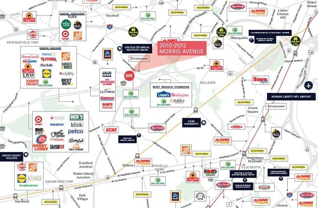
NEARBY LISTINGS FOR SALE OR LEASE
Property Detail
2010 Morris Ave
19-02903-0000-00019
INCL BLK 5 LOTS 4 & 5
Commercialnec
Union
X
New Jersey
34013C0134F
19
2024
0.18 AC
2025
Route 22 East
033100
Northern New Jersey
12,748 SF
Newark, NJ
DEMOGRAPHICS near 2010 Morris Ave
1 mile
3 mile
5 mile
2024 Total Population
23,119
221,543
623,506
2029 Population
22,957
217,516
609,181
Pop Growth 2024-2029
(0.70%)
(1.82%)
(2.30%)
Average Age
40
40
39
2024 Total Households
7,887
77,669
220,073
HH Growth 2024-2029
(0.56%)
(1.93%)
(2.40%)
Median Household Inc
$112,132
$90,958
$71,904
Avg Household Size
2.80
2.80
2.70
2024 Avg HH Vehicles
2.00
2.00
1.00
Median Home Value
$383,133
$402,937
$427,455
Median Year Built
1953
1952
1955
Nearby Places
Map Layers
Map Styles
 Street
 Aerial
Transit
 Traffic
 Biking
Places
Listings with unknown addresses are not visible on the map
- Restaurants
- Banks
- Shops
- Fitness
- Groceries
PUBLIC TRANSPORTATION
COMMUTER RAIL
Union (Raritan Valley Line - NJ Transit Commuter Rail (NJ Transit))
Drive
Walk
Distance
Union (Raritan Valley Line - NJ Transit Commuter Rail (NJ Transit))
5 min
1 min
0.1 mi
Roselle Park (Raritan Valley Line - NJ Transit Commuter Rail (NJ Transit))
Drive
Walk
Distance
Roselle Park (Raritan Valley Line - NJ Transit Commuter Rail (NJ Transit))
7 min
2.2 mi
AIRPORT
Newark Liberty International
Drive
Walk
Distance
Newark Liberty International
11 min
9.2 mi
LaGuardia
Drive
Walk
Distance
LaGuardia
44 min
30.0 mi
John F Kennedy International
Drive
Walk
Distance
John F Kennedy International
54 min
37.9 mi
Freight Ports
Maher Terminal
Drive
Walk
Distance
Maher Terminal
1 min
5.7 mi
Nearby Properties
Address
Land Use
TOTAL SIZE
Lot Size
Zoning
Address
Land Use
TOTAL SIZE
Lot Size
Zoning
32.27 AC
CCRC
Address
Land Use
TOTAL SIZE
Lot Size
Zoning
107.41 AC
Address
Land Use
TOTAL SIZE
Lot Size
Zoning
Address
Land Use
TOTAL SIZE
Lot Size
Zoning
13.80 AC
R1-5
Address
Land Use
TOTAL SIZE
Lot Size
Zoning
1 SF
117.50 AC
Address
Land Use
TOTAL SIZE
Lot Size
Zoning
0.82 AC
Address
Land Use
TOTAL SIZE
Lot Size
Zoning
Address
Land Use
TOTAL SIZE
Lot Size
Zoning
Address
Land Use
TOTAL SIZE
Lot Size
Zoning
2.29 AC
Address
Land Use
TOTAL SIZE
Lot Size
Zoning
117,703 SF
8.29 AC
Address
Land Use
TOTAL SIZE
Lot Size
Zoning
6.05 AC
RO
Address
Land Use
TOTAL SIZE
Lot Size
Zoning
17,416 SF
19.42 AC
Address
Land Use
TOTAL SIZE
Lot Size
Zoning
253,287 SF
6.03 AC
Address
Land Use
TOTAL SIZE
Lot Size
Zoning
103,773 SF
35.47 AC
Address
Land Use
TOTAL SIZE
Lot Size
Zoning
16.10 AC
R1-5
Address
Land Use
TOTAL SIZE
Lot Size
Zoning
4 AC
R1-5
Address
Land Use
TOTAL SIZE
Lot Size
Zoning
Address
Land Use
TOTAL SIZE
Lot Size
Zoning
37,191 SF
8.52 AC
Address
Land Use
TOTAL SIZE
Lot Size
Zoning
8.10 AC
Address
Land Use
TOTAL SIZE
Lot Size
Zoning
104,883 SF
8 AC
Address
Land Use
TOTAL SIZE
Lot Size
Zoning
1.53 AC
RMFA
Address
Land Use
TOTAL SIZE
Lot Size
Zoning
16.82 AC
R1-7
Address
Land Use
TOTAL SIZE
Lot Size
Zoning
12.20 AC
Address
Land Use
TOTAL SIZE
Lot Size
Zoning
55,362 SF
9.58 AC
Address
Land Use
TOTAL SIZE
Lot Size
Zoning
4.82 AC
Address
Land Use
TOTAL SIZE
Lot Size
Zoning
1.45 AC
Address
Land Use
TOTAL SIZE
Lot Size
Zoning
100,660 SF
1.61 AC
Address
Land Use
TOTAL SIZE
Lot Size
Zoning
2.71 AC
RD-2
Address
Land Use
TOTAL SIZE
Lot Size
Zoning
Address
Land Use
TOTAL SIZE
Lot Size
Zoning
224.81 AC
The World's #1 Commercial Real Estate Marketplace
Connect with us
© 2026 CoStar Group
The information above has been obtained from sources believed reliable. While we do not doubt its accuracy we have not verified it and make no guarantee, warranty or representation about it. It is your responsibility to independently confirm its accuracy and completeness. Any projections, opinions, assumptions, or estimates used are for example only and do not represent the current or future performance of the property. The value of this transaction to you depends on tax and other factors which should be evaluated by your tax, financial, and legal advisors. You and your advisors should conduct a careful, independent investigation of the property to determine to your satisfaction the suitability of the property for your needs.