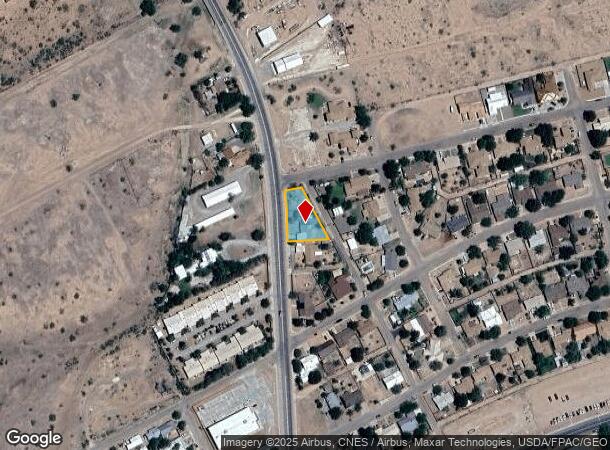
Property Record
2010 N State Highway 118, Alpine, TX 79830
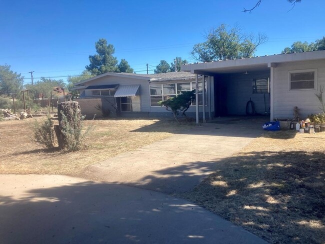
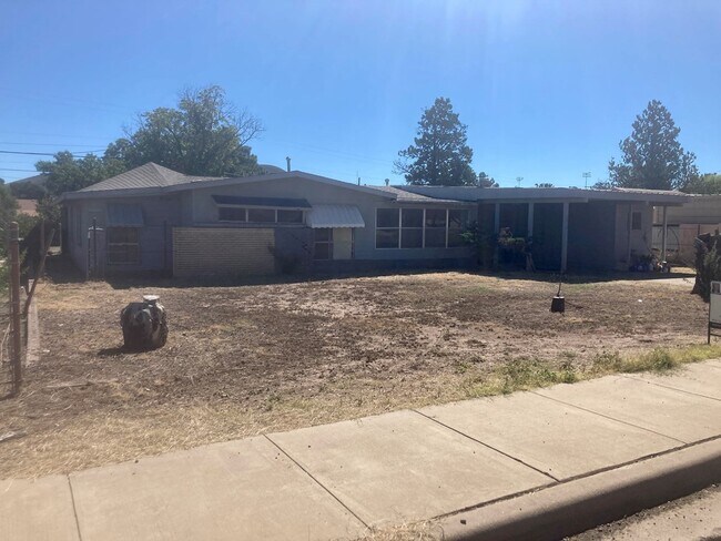
This Property Is For Sale
NEARBY LISTINGS FOR SALE OR LEASE
-
-
No Photo
-
-
-
View all Alpine listings for sale on LoopNet.com
Property Detail
2010 N State Highway 118
Texas West Area
Bl Bonnett
Other Market Areas
Brewster
10190
Texas
Sfr
0.22 AC
2,345 SF
DEMOGRAPHICS near 2010 N State Highway 118
1 Mile
3 Mile
5 Mile
2024 Total Population
2,520
7,219
7,361
2029 Population
2,505
7,238
7,364
Pop Growth 2024-2029
(0.60%)
+ 0.26%
+ 0.04%
Average Age
39
41
42
2024 Total Households
981
3,091
3,156
HH Growth 2024-2029
(0.61%)
+ 0.36%
+ 0.10%
Median Household Inc
$50,333
$49,667
$50,802
Avg Household Size
2.10
2.20
2.20
2024 Avg HH Vehicles
2.00
2.00
2.00
Median Home Value
$255,369
$198,421
$199,754
Median Year Built
1967
1974
1974
Nearby Places
- Restaurants
- Banks
- Shops
- Fitness
- Groceries
PUBLIC TRANSPORTATION
COMMUTER RAIL
Alpine Amtrak Station (Sunset Limited - Amtrak, Texas Eagle - Amtrak)
DRIVE
WALK
Distance
Alpine Amtrak Station (Sunset Limited - Amtrak, Texas Eagle - Amtrak)
2 min
1.4 mi
Freight Ports
Port of Corpus Christi
DRIVE
WALK
Distance
Port of Corpus Christi
524 min
522.7 mi
Nearby Properties
Address
Land Use
TOTAL SIZE
Lot Size
Zoning
Address
Land Use
TOTAL SIZE
Lot Size
Zoning
Address
Land Use
TOTAL SIZE
Lot Size
Zoning
47,382 SF
1.78 AC
Address
Land Use
TOTAL SIZE
Lot Size
Zoning
39,269 SF
Address
Land Use
TOTAL SIZE
Lot Size
Zoning
64,383 SF
5.11 AC
Address
Land Use
TOTAL SIZE
Lot Size
Zoning
28,664 SF
3.84 AC
Address
Land Use
TOTAL SIZE
Lot Size
Zoning
24,525 SF
2.48 AC
Address
Land Use
TOTAL SIZE
Lot Size
Zoning
136,932 SF
5 AC
Address
Land Use
TOTAL SIZE
Lot Size
Zoning
74,493 SF
1.61 AC
Address
Land Use
TOTAL SIZE
Lot Size
Zoning
190,998 SF
15 AC
Address
Land Use
TOTAL SIZE
Lot Size
Zoning
18,112 SF
6.19 AC
Address
Land Use
TOTAL SIZE
Lot Size
Zoning
65,047 SF
3.32 AC
Address
Land Use
TOTAL SIZE
Lot Size
Zoning
104,822 SF
20.21 AC
Address
Land Use
TOTAL SIZE
Lot Size
Zoning
138,883 SF
13.75 AC
Address
Land Use
TOTAL SIZE
Lot Size
Zoning
21,085 SF
0.50 AC
Address
Land Use
TOTAL SIZE
Lot Size
Zoning
19,872 SF
10.01 AC
Address
Land Use
TOTAL SIZE
Lot Size
Zoning
33,934 SF
3 AC
Address
Land Use
TOTAL SIZE
Lot Size
Zoning
12,800 SF
0.41 AC
Address
Land Use
TOTAL SIZE
Lot Size
Zoning
33,064 SF
1.77 AC
Address
Land Use
TOTAL SIZE
Lot Size
Zoning
35,075 SF
3.04 AC
Address
Land Use
TOTAL SIZE
Lot Size
Zoning
59,241 SF
5.48 AC
Address
Land Use
TOTAL SIZE
Lot Size
Zoning
19,646 SF
0.24 AC
Address
Land Use
TOTAL SIZE
Lot Size
Zoning
21,065 SF
1.76 AC
Address
Land Use
TOTAL SIZE
Lot Size
Zoning
19,251 SF
0.39 AC
Address
Land Use
TOTAL SIZE
Lot Size
Zoning
22,185 SF
3.13 AC
Address
Land Use
TOTAL SIZE
Lot Size
Zoning
43,295 SF
4.94 AC
Address
Land Use
TOTAL SIZE
Lot Size
Zoning
24,495 SF
0.50 AC
Address
Land Use
TOTAL SIZE
Lot Size
Zoning
23,292 SF
1.67 AC
Address
Land Use
TOTAL SIZE
Lot Size
Zoning
8,874 SF
1.24 AC
The World's #1 Commercial Real Estate Marketplace
Connect with us
© 2025 CoStar Group
The information above has been obtained from sources believed reliable. While we do not doubt its accuracy we have not verified it and make no guarantee, warranty or representation about it. It is your responsibility to independently confirm its accuracy and completeness. Any projections, opinions, assumptions, or estimates used are for example only and do not represent the current or future performance of the property. The value of this transaction to you depends on tax and other factors which should be evaluated by your tax, financial, and legal advisors. You and your advisors should conduct a careful, independent investigation of the property to determine to your satisfaction the suitability of the property for your needs.