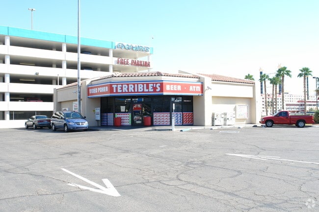
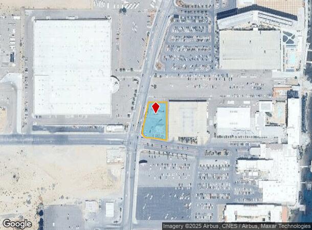
Property Record
2010 S Casino Dr, Laughlin, NV 89029

NEARBY LISTINGS FOR SALE OR LEASE
-
-
View all Laughlin listings for sale on LoopNet.com
Property Detail
2010 S Casino Dr
Las Vegas-Henderson-North Las Vegas, NV
Parcel Map File 73 Page 99
264-13-601-008
PARCEL MAP FILE 73 PAGE 99 LOT 2
Storebuilding
Clark
AO
Nevada
04015C4462G
2
2025
0.72 AC
2025
Outlying S Clark Cnty
005702
Las Vegas
2,705 SF
DEMOGRAPHICS near 2010 S Casino Dr
1 Mile
3 Mile
5 Mile
2024 Total Population
649
9,715
37,978
2029 Population
684
10,699
41,862
Pop Growth 2024-2029
+ 5.39%
+ 10.13%
+ 10.23%
Average Age
50
54
50
2024 Total Households
334
4,834
17,764
HH Growth 2024-2029
+ 6.29%
+ 10.47%
+ 10.57%
Median Household Inc
$11,607
$42,470
$39,591
Avg Household Size
1.90
2.00
2.10
2024 Avg HH Vehicles
1.00
2.00
2.00
Median Home Value
$344,859
$305,282
$201,352
Median Year Built
1991
1997
1991
Nearby Places
Map Layers
Map Styles
 Street
 Aerial
- Restaurants
- Banks
- Shops
- Fitness
- Groceries
PUBLIC TRANSPORTATION
AIRPORT
Laughlin/Bullhead International
DRIVE
WALK
Distance
Laughlin/Bullhead International
9 min
3.3 mi
Freight Ports
Port of San Diego
DRIVE
WALK
Distance
Port of San Diego
388 min
343.3 mi
Nearby Properties
Address
Land Use
TOTAL SIZE
Lot Size
Zoning
Address
Land Use
TOTAL SIZE
Lot Size
Zoning
69,478 SF
17.20 AC
H1
Address
Land Use
TOTAL SIZE
Lot Size
Zoning
196,664 SF
18.43 AC
H1
Address
Land Use
TOTAL SIZE
Lot Size
Zoning
235,806 SF
34.57 AC
H1
Address
Land Use
TOTAL SIZE
Lot Size
Zoning
188,121 SF
44.47 AC
Address
Land Use
TOTAL SIZE
Lot Size
Zoning
15,750 SF
27.78 AC
H1
Address
Land Use
TOTAL SIZE
Lot Size
Zoning
8,976 SF
5.40 AC
H1
Address
Land Use
TOTAL SIZE
Lot Size
Zoning
68.87 AC
Address
Land Use
TOTAL SIZE
Lot Size
Zoning
850,418 SF
20.44 AC
H1
Address
Land Use
TOTAL SIZE
Lot Size
Zoning
21,950 SF
7.57 AC
H1
Address
Land Use
TOTAL SIZE
Lot Size
Zoning
274,070 SF
10 AC
H1
Address
Land Use
TOTAL SIZE
Lot Size
Zoning
55,402 SF
3.24 AC
Address
Land Use
TOTAL SIZE
Lot Size
Zoning
1,011,986 SF
17.67 AC
H1
Address
Land Use
TOTAL SIZE
Lot Size
Zoning
80 AC
RU
Address
Land Use
TOTAL SIZE
Lot Size
Zoning
1,606 SF
51.05 AC
Address
Land Use
TOTAL SIZE
Lot Size
Zoning
109,753 SF
15.58 AC
Address
Land Use
TOTAL SIZE
Lot Size
Zoning
150,175 SF
8.88 AC
Address
Land Use
TOTAL SIZE
Lot Size
Zoning
2,906 SF
14.24 AC
RU
Address
Land Use
TOTAL SIZE
Lot Size
Zoning
8,747 SF
320 AC
PF
Address
Land Use
TOTAL SIZE
Lot Size
Zoning
30,040 SF
69.29 AC
RVP
Address
Land Use
TOTAL SIZE
Lot Size
Zoning
896 SF
27.33 AC
Address
Land Use
TOTAL SIZE
Lot Size
Zoning
68.10 AC
Address
Land Use
TOTAL SIZE
Lot Size
Zoning
27,723 SF
11.07 AC
Address
Land Use
TOTAL SIZE
Lot Size
Zoning
7,861 SF
17 AC
Address
Land Use
TOTAL SIZE
Lot Size
Zoning
52,001 SF
5.70 AC
Address
Land Use
TOTAL SIZE
Lot Size
Zoning
42,243 SF
1.14 AC
Address
Land Use
TOTAL SIZE
Lot Size
Zoning
139,189 SF
5.29 AC
RU
Address
Land Use
TOTAL SIZE
Lot Size
Zoning
54,323 SF
12.01 AC
Address
Land Use
TOTAL SIZE
Lot Size
Zoning
8.75 AC
Address
Land Use
TOTAL SIZE
Lot Size
Zoning
1,358 SF
39.50 AC
Address
Land Use
TOTAL SIZE
Lot Size
Zoning
The World's #1 Commercial Real Estate Marketplace
Connect with us
© 2026 CoStar Group
The information above has been obtained from sources believed reliable. While we do not doubt its accuracy we have not verified it and make no guarantee, warranty or representation about it. It is your responsibility to independently confirm its accuracy and completeness. Any projections, opinions, assumptions, or estimates used are for example only and do not represent the current or future performance of the property. The value of this transaction to you depends on tax and other factors which should be evaluated by your tax, financial, and legal advisors. You and your advisors should conduct a careful, independent investigation of the property to determine to your satisfaction the suitability of the property for your needs.