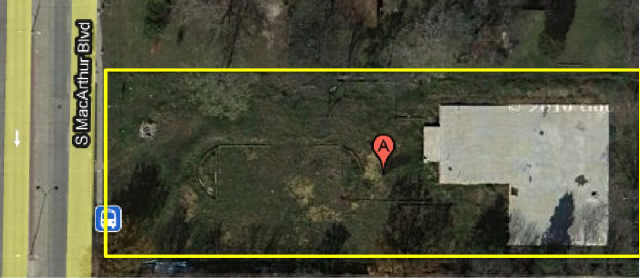
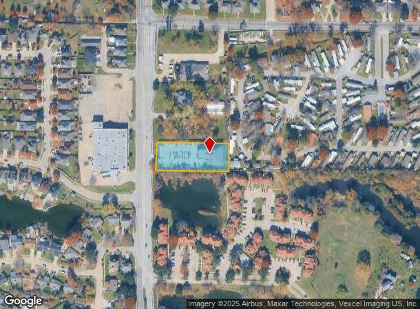
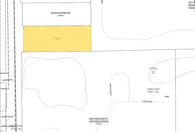
Property Record
2010 S Macarthur Blvd, Irving, TX 75060
NEARBY LISTINGS FOR SALE OR LEASE
Property Detail
2010 S Macarthur Blvd
Dallas-Fort Worth-Arlington, TX
Evangelic Church
32110990010010000
EVANGELIC CHURCH BLK 1 LT 1 ACS 1.062 INT201600180641 DD06232016 CO-DC 1109900100100 1CI11099001
Religious
Dallas
AE
Texas
48113C0315L
1
0
1.06 AC
2025
South Irving
015102
Dallas/Ft Worth
8,836 SF
DEMOGRAPHICS near 2010 S Macarthur Blvd
1 Mile
3 Mile
5 Mile
2024 Total Population
13,322
84,477
209,944
2029 Population
13,110
83,380
207,539
Pop Growth 2024-2029
(1.59%)
(1.30%)
(1.15%)
Average Age
38
36
35
2024 Total Households
4,016
25,712
67,559
HH Growth 2024-2029
(1.89%)
(1.54%)
(1.38%)
Median Household Inc
$63,651
$59,535
$57,924
Avg Household Size
3.20
3.20
3.00
2024 Avg HH Vehicles
2.00
2.00
2.00
Median Home Value
$207,471
$206,219
$206,420
Median Year Built
1972
1969
1973
Nearby Places
Map Layers
Map Styles
 Street
 Aerial
- Restaurants
- Banks
- Shops
- Fitness
- Groceries
PUBLIC TRANSPORTATION
COMMUTER RAIL
Downtown Irving/Heritage Crossing Station (TRINITY RAILWAY - Dallas Area Rapid Transit (DART), Trinity Railway Express - Dallas Area Rapid Transit (DART))
DRIVE
WALK
Distance
Downtown Irving/Heritage Crossing Station (TRINITY RAILWAY - Dallas Area Rapid Transit (DART), Trinity Railway Express - Dallas Area Rapid Transit (DART))
5 min
2.3 mi
West Irving (TRINITY RAILWAY - Dallas Area Rapid Transit (DART), Trinity Railway Express - Dallas Area Rapid Transit (DART))
DRIVE
WALK
Distance
West Irving (TRINITY RAILWAY - Dallas Area Rapid Transit (DART), Trinity Railway Express - Dallas Area Rapid Transit (DART))
10 min
4.5 mi
AIRPORT
Dallas Love Field
DRIVE
WALK
Distance
Dallas Love Field
22 min
9.9 mi
Dallas-Fort Worth International
DRIVE
WALK
Distance
Dallas-Fort Worth International
20 min
11.8 mi
Freight Ports
Port of Shreveport
DRIVE
WALK
Distance
Port of Shreveport
227 min
208.2 mi
Nearby Properties
Address
Land Use
TOTAL SIZE
Lot Size
Zoning
Address
Land Use
TOTAL SIZE
Lot Size
Zoning
1,080,000 SF
51.04 AC
Z123
Address
Land Use
TOTAL SIZE
Lot Size
Zoning
703,500 SF
47.38 AC
Z236
Address
Land Use
TOTAL SIZE
Lot Size
Zoning
496,283 SF
246.29 AC
Z236
Address
Land Use
TOTAL SIZE
Lot Size
Zoning
755,355 SF
40.84 AC
Z123
Address
Land Use
TOTAL SIZE
Lot Size
Zoning
585,000 SF
27.06 AC
Z123
Address
Land Use
TOTAL SIZE
Lot Size
Zoning
168,598 SF
11.33 AC
Z128
Address
Land Use
TOTAL SIZE
Lot Size
Zoning
641,780 SF
34.38 AC
Z236
Address
Land Use
TOTAL SIZE
Lot Size
Zoning
197,000 SF
25.51 AC
Z236
Address
Land Use
TOTAL SIZE
Lot Size
Zoning
602,000 SF
72.59 AC
Z123
Address
Land Use
TOTAL SIZE
Lot Size
Zoning
643,370 SF
22.95 AC
Z393
Address
Land Use
TOTAL SIZE
Lot Size
Zoning
120,000 SF
9.94 AC
Z393
Address
Land Use
TOTAL SIZE
Lot Size
Zoning
268,930 SF
46.40 AC
Z325
Address
Land Use
TOTAL SIZE
Lot Size
Zoning
397,711 SF
18.27 AC
Z123
Address
Land Use
TOTAL SIZE
Lot Size
Zoning
392,220 SF
24.55 AC
Z102
Address
Land Use
TOTAL SIZE
Lot Size
Zoning
237,472 SF
9.31 AC
Z176
Address
Land Use
TOTAL SIZE
Lot Size
Zoning
315,000 SF
16.30 AC
Z236
Address
Land Use
TOTAL SIZE
Lot Size
Zoning
310,047 SF
16.40 AC
Z236
Address
Land Use
TOTAL SIZE
Lot Size
Zoning
344,400 SF
17.35 AC
Z236
Address
Land Use
TOTAL SIZE
Lot Size
Zoning
322,215 SF
19.77 AC
Z236
Address
Land Use
TOTAL SIZE
Lot Size
Zoning
1,035,018 SF
43.12 AC
Address
Land Use
TOTAL SIZE
Lot Size
Zoning
245,800 SF
12.59 AC
Address
Land Use
TOTAL SIZE
Lot Size
Zoning
81,210 SF
53.19 AC
Z324
Address
Land Use
TOTAL SIZE
Lot Size
Zoning
299,500 SF
15.08 AC
Z236
Address
Land Use
TOTAL SIZE
Lot Size
Zoning
233,740 SF
11.82 AC
Z190
Address
Land Use
TOTAL SIZE
Lot Size
Zoning
196,670 SF
10.64 AC
Z177
Address
Land Use
TOTAL SIZE
Lot Size
Zoning
206,856 SF
10.20 AC
Z177
Address
Land Use
TOTAL SIZE
Lot Size
Zoning
143,916 SF
7.22 AC
Z177
Address
Land Use
TOTAL SIZE
Lot Size
Zoning
162,612 SF
7.81 AC
Z392
Address
Land Use
TOTAL SIZE
Lot Size
Zoning
98,200 SF
9.40 AC
Z290
Address
Land Use
TOTAL SIZE
Lot Size
Zoning
97,779 SF
50.53 AC
Z324
The World's #1 Commercial Real Estate Marketplace
Connect with us
© 2025 CoStar Group
The information above has been obtained from sources believed reliable. While we do not doubt its accuracy we have not verified it and make no guarantee, warranty or representation about it. It is your responsibility to independently confirm its accuracy and completeness. Any projections, opinions, assumptions, or estimates used are for example only and do not represent the current or future performance of the property. The value of this transaction to you depends on tax and other factors which should be evaluated by your tax, financial, and legal advisors. You and your advisors should conduct a careful, independent investigation of the property to determine to your satisfaction the suitability of the property for your needs.