Property Record
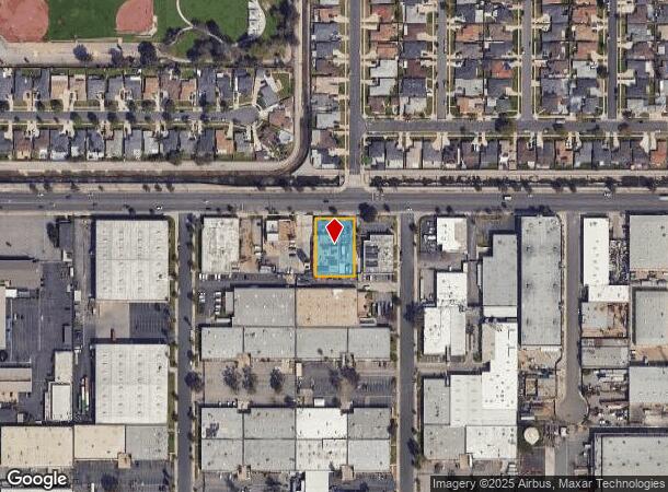
2010 W 135Th St, Gardena, CA 90249
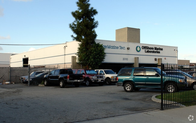
This Property Is For Sale
NEARBY LISTINGS FOR SALE OR LEASE
Property Detail
2010 W 135Th St
Los Angeles-Long Beach-Glendale, CA
City Of Gardena
4061-025-101
*TR=PARCEL MAP AS PER BK 140 P 10-14 OF PM LOT 27
Warehouse
Los Angeles
X
California
06037C1790F
27
2024
0.45 AC
2025
Gardena/Hawthorne
602900
Los Angeles
8,568 SF
DEMOGRAPHICS near 2010 W 135Th St
1 Mile
3 Mile
5 Mile
2024 Total Population
26,992
312,608
768,396
2029 Population
26,217
302,545
742,824
Pop Growth 2024-2029
(2.87%)
(3.22%)
(3.33%)
Average Age
39
38
38
2024 Total Households
9,208
100,657
238,597
HH Growth 2024-2029
(3.08%)
(3.45%)
(3.52%)
Median Household Inc
$65,655
$66,923
$68,464
Avg Household Size
2.90
3.00
3.10
2024 Avg HH Vehicles
2.00
2.00
2.00
Median Home Value
$675,182
$697,283
$706,931
Median Year Built
1959
1960
1959
Nearby Places
- Restaurants
- Banks
- Shops
- Fitness
- Groceries
PUBLIC TRANSPORTATION
AIRPORT
Los Angeles International
DRIVE
WALK
Distance
Los Angeles International
14 min
8.2 mi
Long Beach (Daugherty Field)
DRIVE
WALK
Distance
Long Beach (Daugherty Field)
22 min
13.8 mi
Bob Hope
DRIVE
WALK
Distance
Bob Hope
40 min
29.3 mi
Nearby Properties
Address
Land Use
TOTAL SIZE
Lot Size
Zoning
Address
Land Use
TOTAL SIZE
Lot Size
Zoning
Address
Land Use
TOTAL SIZE
Lot Size
Zoning
Address
Land Use
TOTAL SIZE
Lot Size
Zoning
Address
Land Use
TOTAL SIZE
Lot Size
Zoning
Address
Land Use
TOTAL SIZE
Lot Size
Zoning
248,531 SF
13.30 AC
LCM11/2-B1
Address
Land Use
TOTAL SIZE
Lot Size
Zoning
227,596 SF
14.38 AC
HAM1YY
Address
Land Use
TOTAL SIZE
Lot Size
Zoning
216,354 SF
3.52 AC
HAC3
Address
Land Use
TOTAL SIZE
Lot Size
Zoning
214,782 SF
3.66 AC
GAR3
Address
Land Use
TOTAL SIZE
Lot Size
Zoning
986,604 SF
42.66 AC
HAM2YY
Address
Land Use
TOTAL SIZE
Lot Size
Zoning
59,422 SF
2.89 AC
HAM2YY
Address
Land Use
TOTAL SIZE
Lot Size
Zoning
544,967 SF
10.74 AC
HAM2YY
Address
Land Use
TOTAL SIZE
Lot Size
Zoning
1,106,631 SF
1.12 AC
INC2YY
Address
Land Use
TOTAL SIZE
Lot Size
Zoning
146,182 SF
CAML*
Address
Land Use
TOTAL SIZE
Lot Size
Zoning
169,426 SF
3.50 AC
LCM11/2-B1
Address
Land Use
TOTAL SIZE
Lot Size
Zoning
121,090 SF
4.18 AC
LCM2*
Address
Land Use
TOTAL SIZE
Lot Size
Zoning
109,179 SF
4.55 AC
LCM2*
Address
Land Use
TOTAL SIZE
Lot Size
Zoning
132,173 SF
11.53 AC
LCM2-B1*
Address
Land Use
TOTAL SIZE
Lot Size
Zoning
147,280 SF
6.58 AC
CAML*
Address
Land Use
TOTAL SIZE
Lot Size
Zoning
483,516 SF
11.10 AC
GAM2
Address
Land Use
TOTAL SIZE
Lot Size
Zoning
242,423 SF
6.62 AC
HAC2
Address
Land Use
TOTAL SIZE
Lot Size
Zoning
118,699 SF
5.21 AC
LCM2-B1*
Address
Land Use
TOTAL SIZE
Lot Size
Zoning
289,834 SF
6.67 AC
LCM2*
Address
Land Use
TOTAL SIZE
Lot Size
Zoning
267,463 SF
INCR
Address
Land Use
TOTAL SIZE
Lot Size
Zoning
111,266 SF
3.42 AC
LAMR1
Address
Land Use
TOTAL SIZE
Lot Size
Zoning
130,337 SF
9.31 AC
HAM2
Address
Land Use
TOTAL SIZE
Lot Size
Zoning
267,463 SF
1.97 AC
INCR
Address
Land Use
TOTAL SIZE
Lot Size
Zoning
138,504 SF
0.59 AC
HAR4*
Address
Land Use
TOTAL SIZE
Lot Size
Zoning
106,411 SF
7.99 AC
GAC2
Address
Land Use
TOTAL SIZE
Lot Size
Zoning
134,131 SF
1.16 AC
GASP
Address
Land Use
TOTAL SIZE
Lot Size
Zoning
93,597 SF
0.32 AC
LCC2
The World's #1 Commercial Real Estate Marketplace
Connect with us
© 2025 CoStar Group
The information above has been obtained from sources believed reliable. While we do not doubt its accuracy we have not verified it and make no guarantee, warranty or representation about it. It is your responsibility to independently confirm its accuracy and completeness. Any projections, opinions, assumptions, or estimates used are for example only and do not represent the current or future performance of the property. The value of this transaction to you depends on tax and other factors which should be evaluated by your tax, financial, and legal advisors. You and your advisors should conduct a careful, independent investigation of the property to determine to your satisfaction the suitability of the property for your needs.