Property Record
2010 W 6Th Ave, Hutchinson, KS 67501
NEARBY LISTINGS FOR SALE OR LEASE
-
-
View all Hutchinson listings for sale on LoopNet.com
Property Detail
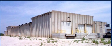
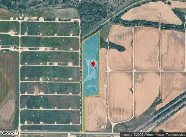
2010 W 6Th Ave
125-22-0-00-01-002.00
Reno Township
Warehouse
RENO TOWNSHIP, S22, T23, R06W, ACRES 10.8, TR BEG SW COR NE/4 TH N 1844.5 6FT TH NELY 412.63FT TH S 1293 .29FT TH W 290FT TH
X
Reno
20155C0287G
Kansas
2024
10.86 AC
2024
Kansas Area
000800
Other Market Areas
1,500 SF
Hutchinson, KS
DEMOGRAPHICS near 2010 W 6Th Ave
1 Mile
3 Mile
5 Mile
2024 Total Population
598
18,851
39,717
2029 Population
579
18,900
39,613
Pop Growth 2024-2029
(3.18%)
+ 0.26%
(0.26%)
Average Age
48
41
41
2024 Total Households
275
8,218
17,142
HH Growth 2024-2029
(3.64%)
+ 0.21%
(0.30%)
Median Household Inc
$38,780
$44,842
$49,390
Avg Household Size
2.00
2.20
2.20
2024 Avg HH Vehicles
2.00
2.00
2.00
Median Home Value
$146,774
$82,401
$100,355
Median Year Built
1975
1951
1958
Nearby Places
Map Layers
Map Styles
 Street
 Aerial
- Restaurants
- Banks
- Shops
- Fitness
- Groceries
PUBLIC TRANSPORTATION
COMMUTER RAIL
Hutchinson Amtrak Station (Southwest Chief - Amtrak)
DRIVE
WALK
Distance
Hutchinson Amtrak Station (Southwest Chief - Amtrak)
8 min
3.3 mi
Freight Ports
Tulsa Port Of Catoosa
DRIVE
WALK
Distance
Tulsa Port Of Catoosa
263 min
241.9 mi
Nearby Properties
Address
Land Use
TOTAL SIZE
Lot Size
Zoning
Address
Land Use
TOTAL SIZE
Lot Size
Zoning
89,458 SF
1.88 AC
P
Address
Land Use
TOTAL SIZE
Lot Size
Zoning
1,960 SF
15.96 AC
Address
Land Use
TOTAL SIZE
Lot Size
Zoning
29,431 SF
1.50 AC
C5
Address
Land Use
TOTAL SIZE
Lot Size
Zoning
36,000 SF
19.49 AC
Address
Land Use
TOTAL SIZE
Lot Size
Zoning
1,136 SF
4.68 AC
Address
Land Use
TOTAL SIZE
Lot Size
Zoning
101,932 SF
1.50 AC
P
Address
Land Use
TOTAL SIZE
Lot Size
Zoning
89,591 SF
3.31 AC
P
Address
Land Use
TOTAL SIZE
Lot Size
Zoning
1,848 SF
12.35 AC
Address
Land Use
TOTAL SIZE
Lot Size
Zoning
59,962 SF
2.52 AC
P
Address
Land Use
TOTAL SIZE
Lot Size
Zoning
16,116 SF
1.37 AC
C1
Address
Land Use
TOTAL SIZE
Lot Size
Zoning
102.35 AC
Address
Land Use
TOTAL SIZE
Lot Size
Zoning
2,250 SF
91.13 AC
Address
Land Use
TOTAL SIZE
Lot Size
Zoning
16,288 SF
0.38 AC
C5
Address
Land Use
TOTAL SIZE
Lot Size
Zoning
11,216 SF
1.88 AC
P
Address
Land Use
TOTAL SIZE
Lot Size
Zoning
61,430 SF
15.62 AC
Address
Land Use
TOTAL SIZE
Lot Size
Zoning
330 SF
127.21 AC
Address
Land Use
TOTAL SIZE
Lot Size
Zoning
48,596 SF
2.59 AC
P
Address
Land Use
TOTAL SIZE
Lot Size
Zoning
47,402 SF
3.71 AC
P
Address
Land Use
TOTAL SIZE
Lot Size
Zoning
56,487 SF
1.70 AC
P
Address
Land Use
TOTAL SIZE
Lot Size
Zoning
1,752 SF
103.49 AC
Address
Land Use
TOTAL SIZE
Lot Size
Zoning
468 SF
34.12 AC
Address
Land Use
TOTAL SIZE
Lot Size
Zoning
4,000 SF
15.02 AC
I2
Address
Land Use
TOTAL SIZE
Lot Size
Zoning
154.95 AC
Address
Land Use
TOTAL SIZE
Lot Size
Zoning
58,907 SF
6.63 AC
Address
Land Use
TOTAL SIZE
Lot Size
Zoning
9,600 SF
17.98 AC
Address
Land Use
TOTAL SIZE
Lot Size
Zoning
2,035 SF
43.77 AC
Address
Land Use
TOTAL SIZE
Lot Size
Zoning
43,497 SF
5.73 AC
P
Address
Land Use
TOTAL SIZE
Lot Size
Zoning
39,856 SF
12.80 AC
PI
Address
Land Use
TOTAL SIZE
Lot Size
Zoning
2,560 SF
152.40 AC
Address
Land Use
TOTAL SIZE
Lot Size
Zoning
23,424 SF
0.80 AC
C5
The World's #1 Commercial Real Estate Marketplace
Connect with us
© 2025 CoStar Group
The information above has been obtained from sources believed reliable. While we do not doubt its accuracy we have not verified it and make no guarantee, warranty or representation about it. It is your responsibility to independently confirm its accuracy and completeness. Any projections, opinions, assumptions, or estimates used are for example only and do not represent the current or future performance of the property. The value of this transaction to you depends on tax and other factors which should be evaluated by your tax, financial, and legal advisors. You and your advisors should conduct a careful, independent investigation of the property to determine to your satisfaction the suitability of the property for your needs.