Property Record
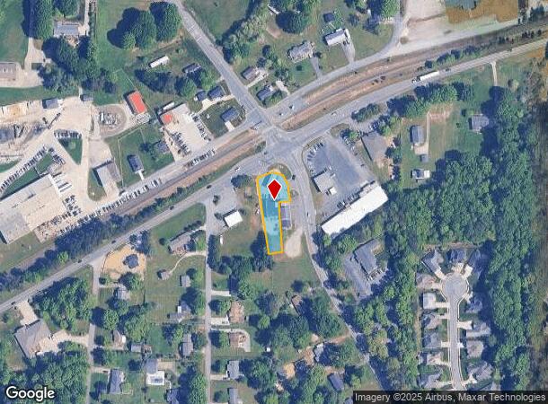
2010 W Mountain St, Kernersville, NC 27284
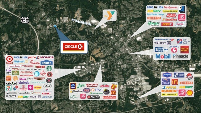
NEARBY LISTINGS FOR SALE OR LEASE
Property Detail
2010 W Mountain St
Winston-Salem, NC
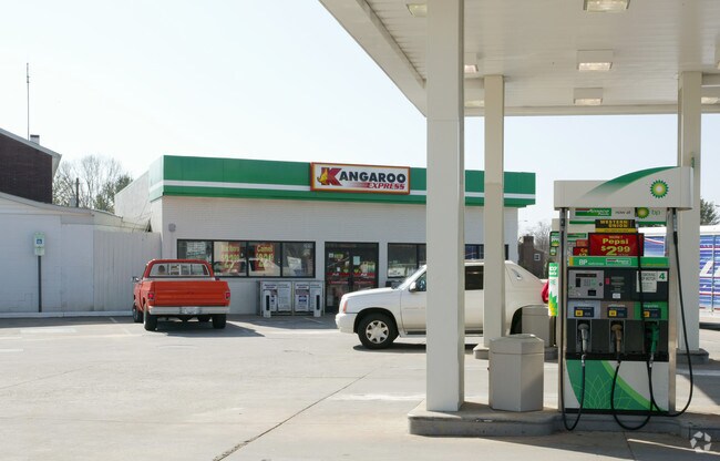
Bp Station
6866-99-7396
BP STATION (KANGAROO) LO:038W BL:5345 BU:1
Storebuilding
Forsyth
X
North Carolina
3710686600J
38w
0
0.46 AC
2025
Kernersville
003004
Greensboro/Winston-Salem
2,400 SF
DEMOGRAPHICS near 2010 W Mountain St
1 Mile
3 Mile
5 Mile
2024 Total Population
3,198
29,661
72,179
2029 Population
3,326
30,761
75,038
Pop Growth 2024-2029
+ 4.00%
+ 3.71%
+ 3.96%
Average Age
44
42
41
2024 Total Households
1,286
12,372
29,450
HH Growth 2024-2029
+ 3.97%
+ 3.69%
+ 3.97%
Median Household Inc
$92,472
$76,498
$69,719
Avg Household Size
2.50
2.40
2.40
2024 Avg HH Vehicles
2.00
2.00
2.00
Median Home Value
$287,120
$239,141
$214,684
Median Year Built
1989
1986
1988
Nearby Places
Map Layers
Map Styles
 Street
 Aerial
- Restaurants
- Banks
- Shops
- Fitness
- Groceries
PUBLIC TRANSPORTATION
AIRPORT
Piedmont Triad International
DRIVE
WALK
Distance
Piedmont Triad International
26 min
16.5 mi
SALE & LEASE HISTORY
LISTING DATE
SALE/LEASE

May 27, 2021
For Sale
Nearby Properties
Address
Land Use
TOTAL SIZE
Lot Size
Zoning
Address
Land Use
TOTAL SIZE
Lot Size
Zoning
73,908 SF
14.40 AC
GB-S
Address
Land Use
TOTAL SIZE
Lot Size
Zoning
77,879 SF
9.56 AC
GB-S
Address
Land Use
TOTAL SIZE
Lot Size
Zoning
576,252 SF
59.82 AC
GI,LI
Address
Land Use
TOTAL SIZE
Lot Size
Zoning
188,273 SF
54.55 AC
IP
Address
Land Use
TOTAL SIZE
Lot Size
Zoning
70,113 SF
19.06 AC
RM18-S
Address
Land Use
TOTAL SIZE
Lot Size
Zoning
115,838 SF
14.41 AC
GI-C
Address
Land Use
TOTAL SIZE
Lot Size
Zoning
202,539 SF
23.70 AC
HB-S
Address
Land Use
TOTAL SIZE
Lot Size
Zoning
545,857 SF
51.60 AC
GI
Address
Land Use
TOTAL SIZE
Lot Size
Zoning
78,274 SF
27.95 AC
RM8-S
Address
Land Use
TOTAL SIZE
Lot Size
Zoning
451.32 AC
MU-C
Address
Land Use
TOTAL SIZE
Lot Size
Zoning
136,068 SF
19.46 AC
HB-S
Address
Land Use
TOTAL SIZE
Lot Size
Zoning
121,981 SF
14.48 AC
HB-S
Address
Land Use
TOTAL SIZE
Lot Size
Zoning
83,774 SF
7.51 AC
GB-S
Address
Land Use
TOTAL SIZE
Lot Size
Zoning
83,027 SF
14.47 AC
HB-S,LO-S
Address
Land Use
TOTAL SIZE
Lot Size
Zoning
98,617 SF
37.44 AC
RS20
Address
Land Use
TOTAL SIZE
Lot Size
Zoning
122,682 SF
9.07 AC
HB-S
Address
Land Use
TOTAL SIZE
Lot Size
Zoning
102,809 SF
16.74 AC
BI
Address
Land Use
TOTAL SIZE
Lot Size
Zoning
77,891 SF
20.91 AC
RS9
Address
Land Use
TOTAL SIZE
Lot Size
Zoning
94,092 SF
15.31 AC
RM18
Address
Land Use
TOTAL SIZE
Lot Size
Zoning
52,480 SF
30.51 AC
BI
Address
Land Use
TOTAL SIZE
Lot Size
Zoning
93,437 SF
11.59 AC
HB-S
Address
Land Use
TOTAL SIZE
Lot Size
Zoning
102,950 SF
21.98 AC
RS12
Address
Land Use
TOTAL SIZE
Lot Size
Zoning
71,538 SF
9.02 AC
IP
Address
Land Use
TOTAL SIZE
Lot Size
Zoning
378,330 SF
74.78 AC
GI,GI-S,RS
Address
Land Use
TOTAL SIZE
Lot Size
Zoning
52,792 SF
25.21 AC
BI
Address
Land Use
TOTAL SIZE
Lot Size
Zoning
66,963 SF
5.67 AC
HB-S
Address
Land Use
TOTAL SIZE
Lot Size
Zoning
75,229 SF
23.45 AC
IP
Address
Land Use
TOTAL SIZE
Lot Size
Zoning
89,697 SF
5.99 AC
RM18-S
Address
Land Use
TOTAL SIZE
Lot Size
Zoning
58,600 SF
8.41 AC
GI,RM18
Address
Land Use
TOTAL SIZE
Lot Size
Zoning
41,290 SF
4.08 AC
CB
The World's #1 Commercial Real Estate Marketplace
Connect with us
© 2026 CoStar Group
The information above has been obtained from sources believed reliable. While we do not doubt its accuracy we have not verified it and make no guarantee, warranty or representation about it. It is your responsibility to independently confirm its accuracy and completeness. Any projections, opinions, assumptions, or estimates used are for example only and do not represent the current or future performance of the property. The value of this transaction to you depends on tax and other factors which should be evaluated by your tax, financial, and legal advisors. You and your advisors should conduct a careful, independent investigation of the property to determine to your satisfaction the suitability of the property for your needs.