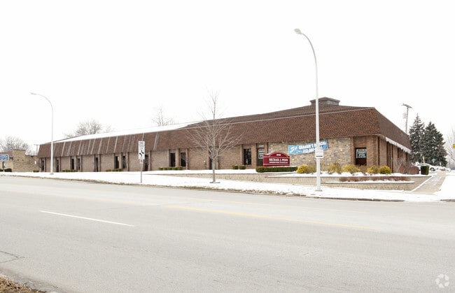
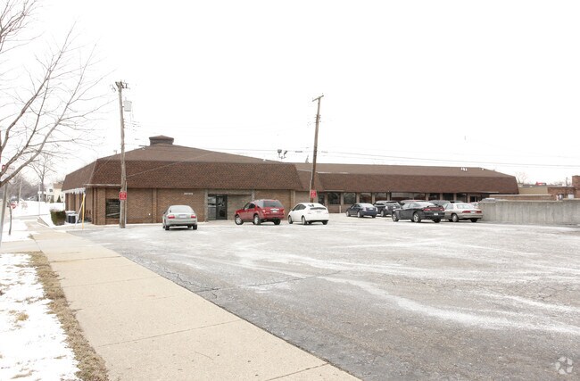
Property Record
20100-20130 Outer Dr, Dearborn, MI 48124
NEARBY LISTINGS FOR SALE OR LEASE
Property Detail
20100-20130 Outer Dr
Detroit-Warren-Dearborn, MI
Dearborn Center
32-09-281-03-020
LOT 134 & 135 DEARBORN CENTER SUB
Officebuilding
Wayne
X
Michigan
26163C0242E
134-135
2025
0.28 AC
2025
Dearborn
575100
Detroit
6,104 SF
DEMOGRAPHICS near 20100-20130 Outer Dr
1 Mile
3 Mile
5 Mile
2024 Total Population
14,213
109,828
320,276
2029 Population
13,604
105,754
309,083
Pop Growth 2024-2029
(4.28%)
(3.71%)
(3.49%)
Average Age
41
39
38
2024 Total Households
5,920
42,070
120,755
HH Growth 2024-2029
(4.29%)
(3.66%)
(3.52%)
Median Household Inc
$85,753
$62,236
$56,845
Avg Household Size
2.40
2.60
2.60
2024 Avg HH Vehicles
2.00
2.00
2.00
Median Home Value
$195,156
$168,891
$148,755
Median Year Built
1950
1955
1955
Nearby Places
Map Layers
Map Styles
 Street
 Aerial
- Restaurants
- Banks
- Shops
- Fitness
- Groceries
PUBLIC TRANSPORTATION
COMMUTER RAIL
Dearborn (Wolverine - Amtrak)
DRIVE
WALK
Distance
Dearborn (Wolverine - Amtrak)
5 min
1.8 mi
AIRPORT
Detroit Metro Wayne County
DRIVE
WALK
Distance
Detroit Metro Wayne County
22 min
11.0 mi
Windsor International
DRIVE
WALK
Distance
Windsor International
44 min
22.9 mi
Freight Ports
Port of Toledo
DRIVE
WALK
Distance
Port of Toledo
72 min
54.0 mi
Nearby Properties
Address
Land Use
TOTAL SIZE
Lot Size
Zoning
Address
Land Use
TOTAL SIZE
Lot Size
Zoning
5,597,761 SF
73.85 AC
IB
Address
Land Use
TOTAL SIZE
Lot Size
Zoning
373,209 SF
349 AC
IC
Address
Land Use
TOTAL SIZE
Lot Size
Zoning
675,440 SF
66.32 AC
IB
Address
Land Use
TOTAL SIZE
Lot Size
Zoning
1,209,711 SF
69.44 AC
IB
Address
Land Use
TOTAL SIZE
Lot Size
Zoning
590,893 SF
51.81 AC
IB
Address
Land Use
TOTAL SIZE
Lot Size
Zoning
324,414 SF
18.68 AC
RD
Address
Land Use
TOTAL SIZE
Lot Size
Zoning
854,358 SF
12.49 AC
BC
Address
Land Use
TOTAL SIZE
Lot Size
Zoning
Address
Land Use
TOTAL SIZE
Lot Size
Zoning
349,045 SF
40.28 AC
IB
Address
Land Use
TOTAL SIZE
Lot Size
Zoning
78,450 SF
12.03 AC
BC
Address
Land Use
TOTAL SIZE
Lot Size
Zoning
228,519 SF
6.16 AC
BC
Address
Land Use
TOTAL SIZE
Lot Size
Zoning
108,960 SF
5.23 AC
OS
Address
Land Use
TOTAL SIZE
Lot Size
Zoning
219,434 SF
23.91 AC
BC
Address
Land Use
TOTAL SIZE
Lot Size
Zoning
Address
Land Use
TOTAL SIZE
Lot Size
Zoning
562,922 SF
30 AC
BC
Address
Land Use
TOTAL SIZE
Lot Size
Zoning
107,772 SF
8 AC
BC
Address
Land Use
TOTAL SIZE
Lot Size
Zoning
126,712 SF
4.52 AC
BC
Address
Land Use
TOTAL SIZE
Lot Size
Zoning
32,608 SF
46.51 AC
BC
Address
Land Use
TOTAL SIZE
Lot Size
Zoning
810,000 SF
23.15 AC
BC
Address
Land Use
TOTAL SIZE
Lot Size
Zoning
463,642 SF
22.82 AC
Address
Land Use
TOTAL SIZE
Lot Size
Zoning
247,588 SF
4.12 AC
RE
Address
Land Use
TOTAL SIZE
Lot Size
Zoning
148,491 SF
11.34 AC
BC
Address
Land Use
TOTAL SIZE
Lot Size
Zoning
240,425 SF
6.39 AC
IB
Address
Land Use
TOTAL SIZE
Lot Size
Zoning
328,480 SF
11.54 AC
IA
Address
Land Use
TOTAL SIZE
Lot Size
Zoning
84,333 SF
1.15 AC
BC
Address
Land Use
TOTAL SIZE
Lot Size
Zoning
637,820 SF
10.87 AC
BC
Address
Land Use
TOTAL SIZE
Lot Size
Zoning
63,898 SF
BC
Address
Land Use
TOTAL SIZE
Lot Size
Zoning
86.77 AC
BC
Address
Land Use
TOTAL SIZE
Lot Size
Zoning
107,680 SF
7.46 AC
BC
Address
Land Use
TOTAL SIZE
Lot Size
Zoning
127,391 SF
1.79 AC
BC
The World's #1 Commercial Real Estate Marketplace
Connect with us
© 2026 CoStar Group
The information above has been obtained from sources believed reliable. While we do not doubt its accuracy we have not verified it and make no guarantee, warranty or representation about it. It is your responsibility to independently confirm its accuracy and completeness. Any projections, opinions, assumptions, or estimates used are for example only and do not represent the current or future performance of the property. The value of this transaction to you depends on tax and other factors which should be evaluated by your tax, financial, and legal advisors. You and your advisors should conduct a careful, independent investigation of the property to determine to your satisfaction the suitability of the property for your needs.