Property Record
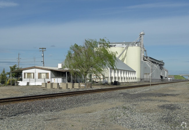
20100 Fairmead Blvd, Madera, CA 93638


NEARBY LISTINGS FOR SALE OR LEASE
-
-
View all Madera listings for sale on LoopNet.com
Property Detail
20100 Fairmead Blvd
029-100-010
SEC 19 T10S R17E
Foodprocessing
Madera
X
California
06039C0900E
1.40 AC
2024
Outlying Madera Cnty
2025
Fresno
000603
Madera, CA
3,660 SF
DEMOGRAPHICS near 20100 Fairmead Blvd
1 Mile
3 Mile
5 Mile
2024 Total Population
294
2,179
12,338
2029 Population
306
2,246
12,901
Pop Growth 2024-2029
+ 4.08%
+ 3.07%
+ 4.56%
Average Age
41
40
38
2024 Total Households
10
225
2,175
HH Growth 2024-2029
0.00%
+ 1.33%
+ 4.64%
Median Household Inc
$59,999
$56,874
$76,267
Avg Household Size
3.90
3.40
3.50
2024 Avg HH Vehicles
2.00
3.00
3.00
Median Home Value
$499,999
$635,000
$335,386
Median Year Built
1987
1975
1983
Nearby Places
Map Layers
Map Styles
 Street
 Aerial
- Restaurants
- Banks
- Shops
- Fitness
- Groceries
PUBLIC TRANSPORTATION
COMMUTER RAIL
Madera Amtrak (San Joaquins - Amtrak)
DRIVE
WALK
Distance
Madera Amtrak (San Joaquins - Amtrak)
14 min
8.3 mi
Freight Ports
Port of Stockton
DRIVE
WALK
Distance
Port of Stockton
116 min
97.7 mi
Nearby Properties
Address
Land Use
TOTAL SIZE
Lot Size
Zoning
Address
Land Use
TOTAL SIZE
Lot Size
Zoning
29,000 SF
37.32 AC
IL
Address
Land Use
TOTAL SIZE
Lot Size
Zoning
14,400 SF
181.61 AC
IL
Address
Land Use
TOTAL SIZE
Lot Size
Zoning
37,307 SF
28.44 AC
ARE-20
Address
Land Use
TOTAL SIZE
Lot Size
Zoning
17,998 SF
11.24 AC
CRG
Address
Land Use
TOTAL SIZE
Lot Size
Zoning
2,832 SF
8.76 AC
IL
Address
Land Use
TOTAL SIZE
Lot Size
Zoning
557.97 AC
ARE-40
Address
Land Use
TOTAL SIZE
Lot Size
Zoning
636.37 AC
ARE-20
Address
Land Use
TOTAL SIZE
Lot Size
Zoning
2,018 SF
76.29 AC
ARE-40
Address
Land Use
TOTAL SIZE
Lot Size
Zoning
37.70 AC
ARE-40
Address
Land Use
TOTAL SIZE
Lot Size
Zoning
4,500 SF
3.35 AC
CRG
Address
Land Use
TOTAL SIZE
Lot Size
Zoning
1,379 SF
156.83 AC
ARE-40
Address
Land Use
TOTAL SIZE
Lot Size
Zoning
75.37 AC
IL
Address
Land Use
TOTAL SIZE
Lot Size
Zoning
12,800 SF
18 AC
ARE-20
Address
Land Use
TOTAL SIZE
Lot Size
Zoning
21,967 SF
1.36 AC
CRG
Address
Land Use
TOTAL SIZE
Lot Size
Zoning
40,000 SF
9.81 AC
IL
Address
Land Use
TOTAL SIZE
Lot Size
Zoning
Address
Land Use
TOTAL SIZE
Lot Size
Zoning
133.70 AC
ARE-40
Address
Land Use
TOTAL SIZE
Lot Size
Zoning
1,336 SF
157.58 AC
ARE-20
Address
Land Use
TOTAL SIZE
Lot Size
Zoning
1,554 SF
155.77 AC
ARE-40
Address
Land Use
TOTAL SIZE
Lot Size
Zoning
4,084 SF
106.31 AC
ARE-40
Address
Land Use
TOTAL SIZE
Lot Size
Zoning
8,000 SF
15.81 AC
ARE-20
Address
Land Use
TOTAL SIZE
Lot Size
Zoning
139.32 AC
ARE-20
Address
Land Use
TOTAL SIZE
Lot Size
Zoning
1,890 SF
174.57 AC
ARE-40
Address
Land Use
TOTAL SIZE
Lot Size
Zoning
186.29 AC
IL
Address
Land Use
TOTAL SIZE
Lot Size
Zoning
1.50 AC
CRG
The World's #1 Commercial Real Estate Marketplace
Connect with us
© 2025 CoStar Group
The information above has been obtained from sources believed reliable. While we do not doubt its accuracy we have not verified it and make no guarantee, warranty or representation about it. It is your responsibility to independently confirm its accuracy and completeness. Any projections, opinions, assumptions, or estimates used are for example only and do not represent the current or future performance of the property. The value of this transaction to you depends on tax and other factors which should be evaluated by your tax, financial, and legal advisors. You and your advisors should conduct a careful, independent investigation of the property to determine to your satisfaction the suitability of the property for your needs.