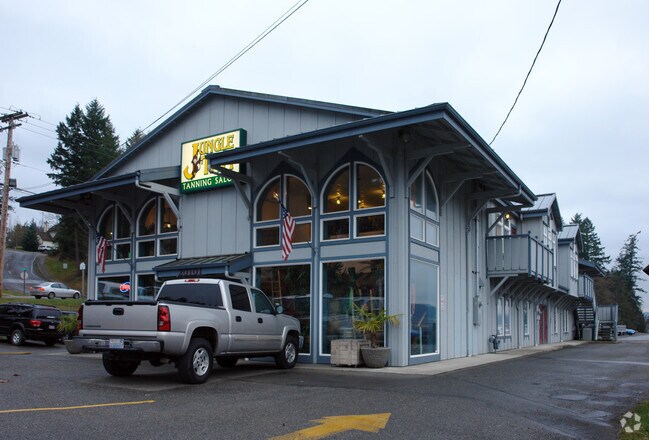
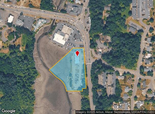
Property Record
20101 Front St Ne, Poulsbo, WA 98370

NEARBY LISTINGS FOR SALE OR LEASE
Property Detail
20101 Front St Ne
Bremerton-Silverdale, WA
Sp 9302180277
152601-1-133-2006
LOT B, CITY OF POULSBO SHORT PLAT P-56, RECORDED IN VOLUME 9 OF SHORT PLATS, PAGE 76, UNDER AUDITOR FILE NOS. 9302180277 AND 9302180278, BEING A PORTION OF GOVERNMENT LOT 3, IN THE NORTHEAST QUARTER, SECTION 15, TOWNSHIP 26 NORTH, RANGE 1 EAST, W.M.,
Commercialnec
Kitsap
AE
Washington
53031C1335C
b
2025
1.61 AC
2026
Poulsbo
090501
Bremerton/Silverdale
8,000 SF
DEMOGRAPHICS near 20101 Front St Ne
1 Mile
3 Mile
5 Mile
2024 Total Population
4,960
19,465
38,670
2029 Population
4,968
19,499
38,681
Pop Growth 2024-2029
+ 0.16%
+ 0.17%
+ 0.03%
Average Age
45
44
42
2024 Total Households
2,174
7,643
14,229
HH Growth 2024-2029
(0.05%)
+ 0.04%
(0.13%)
Median Household Inc
$62,514
$95,170
$96,493
Avg Household Size
2.10
2.40
2.50
2024 Avg HH Vehicles
2.00
2.00
2.00
Median Home Value
$533,588
$557,908
$558,789
Median Year Built
1988
1991
1989
Nearby Places
Map Layers
Map Styles
 Street
 Aerial
- Restaurants
- Banks
- Shops
- Fitness
- Groceries
PUBLIC TRANSPORTATION
AIRPORT
Seattle Paine Field International
DRIVE
WALK
Distance
Seattle Paine Field International
67 min
26.7 mi
Seattle-Tacoma International
DRIVE
WALK
Distance
Seattle-Tacoma International
92 min
46.6 mi
Freight Ports
Port of Seattle
DRIVE
WALK
Distance
Port of Seattle
79 min
37.1 mi
Nearby Properties
Address
Land Use
TOTAL SIZE
Lot Size
Zoning
Address
Land Use
TOTAL SIZE
Lot Size
Zoning
5,198 SF
9.52 AC
RH
Address
Land Use
TOTAL SIZE
Lot Size
Zoning
126,691 SF
6.42 AC
RM
Address
Land Use
TOTAL SIZE
Lot Size
Zoning
140,624 SF
8.46 AC
RH
Address
Land Use
TOTAL SIZE
Lot Size
Zoning
132,992 SF
6.67 AC
RH
Address
Land Use
TOTAL SIZE
Lot Size
Zoning
203,311 SF
20.20 AC
C-4
Address
Land Use
TOTAL SIZE
Lot Size
Zoning
4.06 AC
RM
Address
Land Use
TOTAL SIZE
Lot Size
Zoning
61,458 SF
6.54 AC
RH
Address
Land Use
TOTAL SIZE
Lot Size
Zoning
48,000 SF
0.54 AC
WATER
Address
Land Use
TOTAL SIZE
Lot Size
Zoning
124,970 SF
9.06 AC
C-3
Address
Land Use
TOTAL SIZE
Lot Size
Zoning
94,292 SF
9.34 AC
RL
Address
Land Use
TOTAL SIZE
Lot Size
Zoning
82,081 SF
5.57 AC
RH
Address
Land Use
TOTAL SIZE
Lot Size
Zoning
69,264 SF
4.90 AC
C-1
Address
Land Use
TOTAL SIZE
Lot Size
Zoning
83,314 SF
6.66 AC
BP
Address
Land Use
TOTAL SIZE
Lot Size
Zoning
1,680 SF
14.25 AC
RH
Address
Land Use
TOTAL SIZE
Lot Size
Zoning
70,762 SF
5.90 AC
RH
Address
Land Use
TOTAL SIZE
Lot Size
Zoning
16,358 SF
0.70 AC
C-1
Address
Land Use
TOTAL SIZE
Lot Size
Zoning
103,919 SF
9.02 AC
LI
Address
Land Use
TOTAL SIZE
Lot Size
Zoning
51,096 SF
2.37 AC
C-4
Address
Land Use
TOTAL SIZE
Lot Size
Zoning
98,525 SF
11.40 AC
C-4
Address
Land Use
TOTAL SIZE
Lot Size
Zoning
70,570 SF
6.93 AC
C-3
Address
Land Use
TOTAL SIZE
Lot Size
Zoning
41,492 SF
3.44 AC
RH
Address
Land Use
TOTAL SIZE
Lot Size
Zoning
60,790 SF
5.64 AC
C-3
Address
Land Use
TOTAL SIZE
Lot Size
Zoning
61,185 SF
4.88 AC
C-3
Address
Land Use
TOTAL SIZE
Lot Size
Zoning
35,080 SF
2.99 AC
RH
Address
Land Use
TOTAL SIZE
Lot Size
Zoning
39,474 SF
2.98 AC
RH
Address
Land Use
TOTAL SIZE
Lot Size
Zoning
37,036 SF
2.83 AC
BP
Address
Land Use
TOTAL SIZE
Lot Size
Zoning
41,936 SF
4.03 AC
C-4
Address
Land Use
TOTAL SIZE
Lot Size
Zoning
5.31 AC
LI
Address
Land Use
TOTAL SIZE
Lot Size
Zoning
21,468 SF
0.88 AC
WATER
Address
Land Use
TOTAL SIZE
Lot Size
Zoning
44,446 SF
1.44 AC
C-3
The World's #1 Commercial Real Estate Marketplace
Connect with us
© 2025 CoStar Group
The information above has been obtained from sources believed reliable. While we do not doubt its accuracy we have not verified it and make no guarantee, warranty or representation about it. It is your responsibility to independently confirm its accuracy and completeness. Any projections, opinions, assumptions, or estimates used are for example only and do not represent the current or future performance of the property. The value of this transaction to you depends on tax and other factors which should be evaluated by your tax, financial, and legal advisors. You and your advisors should conduct a careful, independent investigation of the property to determine to your satisfaction the suitability of the property for your needs.