Property Record
20106 2Nd Ave E, Spanaway, WA 98387
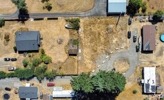
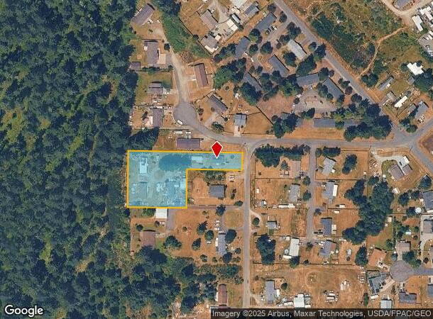
This Property Is For Sale
NEARBY LISTINGS FOR SALE OR LEASE
Property Detail
20106 2Nd Ave E
031804-4037
SECTION 04 TOWNSHIP 18 RANGE 03 QUARTER 42 BEG ON W LI OF NW OF SE OF SEC 4 AT A PT 840 FT N OF SW COR OF SD SUBD TH CONT ON SD W LI N 210 FT TH E PAR/W S LI OF SD SUBD 425 FT TO W LI OF CO RD TH S ALG W LI OF SD CO RD 210 FT TO NE COR OF THAT CERTAI
Mobilemanufacturedhomeregardlessoflandownership
Pierce
X
Washington
53053C0575E
1.43 AC
2024
Spanaway
2025
Seattle/Puget Sound
071416
Seattle-Tacoma-Bellevue, WA
1,332 SF
DEMOGRAPHICS near 20106 2Nd Ave E
1 mile
3 mile
5 mile
2024 Total Population
6,504
39,197
91,613
2029 Population
6,586
39,530
92,619
Pop Growth 2024-2029
+ 1.26%
+ 0.85%
+ 1.10%
Average Age
36
36
38
2024 Total Households
2,161
12,695
30,793
HH Growth 2024-2029
+ 1.34%
+ 0.87%
+ 1.12%
Median Household Inc
$86,360
$100,780
$99,855
Avg Household Size
2.90
3.00
2.80
2024 Avg HH Vehicles
2.00
2.00
2.00
Median Home Value
$422,622
$454,862
$461,372
Median Year Built
1992
1993
1991
Nearby Places
Map Layers
Map Styles
 Street
 Aerial
Transit
 Traffic
 Biking
Places
Listings with unknown addresses are not visible on the map
- Restaurants
- Banks
- Shops
- Fitness
- Groceries
PUBLIC TRANSPORTATION
COMMUTER RAIL
Lakewood Station (Seattle - Tacoma/Lakewood - Sound Transit)
Drive
Walk
Distance
Lakewood Station (Seattle - Tacoma/Lakewood - Sound Transit)
19 min
9.6 mi
AIRPORT
Seattle-Tacoma International
Drive
Walk
Distance
Seattle-Tacoma International
55 min
32.8 mi
Freight Ports
Port of Tacoma
Drive
Walk
Distance
Port of Tacoma
27 min
14.2 mi
Nearby Properties
Address
Land Use
TOTAL SIZE
Lot Size
Zoning
Address
Land Use
TOTAL SIZE
Lot Size
Zoning
1,110,154 SF
53.99 AC
EC
Address
Land Use
TOTAL SIZE
Lot Size
Zoning
862,167 SF
45.51 AC
EC
Address
Land Use
TOTAL SIZE
Lot Size
Zoning
891,600 SF
48.79 AC
EC
Address
Land Use
TOTAL SIZE
Lot Size
Zoning
533,393 SF
26.48 AC
EC
Address
Land Use
TOTAL SIZE
Lot Size
Zoning
522,832 SF
33.82 AC
EC
Address
Land Use
TOTAL SIZE
Lot Size
Zoning
645,993 SF
62.57 AC
EC
Address
Land Use
TOTAL SIZE
Lot Size
Zoning
477,120 SF
27.79 AC
Address
Land Use
TOTAL SIZE
Lot Size
Zoning
191,542 SF
11.78 AC
TCTR
Address
Land Use
TOTAL SIZE
Lot Size
Zoning
405,040 SF
26.44 AC
Address
Land Use
TOTAL SIZE
Lot Size
Zoning
352,930 SF
20.68 AC
Address
Land Use
TOTAL SIZE
Lot Size
Zoning
317,301 SF
17.89 AC
UCOR
Address
Land Use
TOTAL SIZE
Lot Size
Zoning
312,225 SF
13.66 AC
EC
Address
Land Use
TOTAL SIZE
Lot Size
Zoning
176,385 SF
27.35 AC
MSF
Address
Land Use
TOTAL SIZE
Lot Size
Zoning
313,278 SF
57.62 AC
R5
Address
Land Use
TOTAL SIZE
Lot Size
Zoning
195,507 SF
13.10 AC
MSF
Address
Land Use
TOTAL SIZE
Lot Size
Zoning
281,181 SF
18.67 AC
EC
Address
Land Use
TOTAL SIZE
Lot Size
Zoning
218,183 SF
23.37 AC
TCTR
Address
Land Use
TOTAL SIZE
Lot Size
Zoning
127,042 SF
30 AC
EC
Address
Land Use
TOTAL SIZE
Lot Size
Zoning
52,291 SF
26.88 AC
EC
Address
Land Use
TOTAL SIZE
Lot Size
Zoning
74,992 SF
12.98 AC
NMSF
Address
Land Use
TOTAL SIZE
Lot Size
Zoning
42,327 SF
7.15 AC
NCOR
Address
Land Use
TOTAL SIZE
Lot Size
Zoning
49,040 SF
13.52 AC
EC
Address
Land Use
TOTAL SIZE
Lot Size
Zoning
95,273 SF
14.47 AC
NCOR
Address
Land Use
TOTAL SIZE
Lot Size
Zoning
27.97 AC
Address
Land Use
TOTAL SIZE
Lot Size
Zoning
1 SF
49.54 AC
MSF
Address
Land Use
TOTAL SIZE
Lot Size
Zoning
18.30 AC
R4
Address
Land Use
TOTAL SIZE
Lot Size
Zoning
85,215 SF
4.68 AC
NEC
Address
Land Use
TOTAL SIZE
Lot Size
Zoning
56,284 SF
4.65 AC
NCOR
Address
Land Use
TOTAL SIZE
Lot Size
Zoning
63,619 SF
9.20 AC
MSF
Address
Land Use
TOTAL SIZE
Lot Size
Zoning
1 SF
40 AC
EC
The World's #1 Commercial Real Estate Marketplace
Connect with us
© 2026 CoStar Group
The information above has been obtained from sources believed reliable. While we do not doubt its accuracy we have not verified it and make no guarantee, warranty or representation about it. It is your responsibility to independently confirm its accuracy and completeness. Any projections, opinions, assumptions, or estimates used are for example only and do not represent the current or future performance of the property. The value of this transaction to you depends on tax and other factors which should be evaluated by your tax, financial, and legal advisors. You and your advisors should conduct a careful, independent investigation of the property to determine to your satisfaction the suitability of the property for your needs.