Property Record
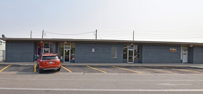
803 E 20Th Street Rd, Greeley, CO 80631

Property Detail
803 E 20Th Street Rd
Greeley, CO
Balsam Village 2Nd Fg
R1047302
GR 2BV L5A BLK2 BALSAM VILLAGE 2ND FG
Duplex
Weld
X
Colorado
08123C1543F
5a
2024
0.14 AC
2025
Greeley
000703
Denver
1,055 SF
NEARBY LISTINGS FOR SALE OR LEASE
DEMOGRAPHICS near 803 E 20Th Street Rd
1 mile
3 mile
5 mile
2024 Total Population
22,086
94,528
144,745
2029 Population
26,049
111,274
170,576
Pop Growth 2024-2029
+ 17.94%
+ 17.72%
+ 17.85%
Average Age
35
36
36
2024 Total Households
7,909
33,430
51,592
HH Growth 2024-2029
+ 18.49%
+ 18.55%
+ 18.59%
Median Household Inc
$45,068
$54,900
$62,925
Avg Household Size
2.60
2.60
2.70
2024 Avg HH Vehicles
2.00
2.00
2.00
Median Home Value
$276,295
$319,705
$339,589
Median Year Built
1969
1977
1988
Nearby Places
Map Layers
Map Styles
 Street
 Aerial
Transit
 Traffic
 Biking
Places
Listings with unknown addresses are not visible on the map
- Restaurants
- Banks
- Shops
- Fitness
- Groceries
SALE & LEASE HISTORY
LISTING DATE
SALE/LEASE

Apr 01, 2020
For Lease
Nearby Properties
Address
Land Use
TOTAL SIZE
Lot Size
Zoning
Address
Land Use
TOTAL SIZE
Lot Size
Zoning
1,572,342 SF
134.62 AC
Address
Land Use
TOTAL SIZE
Lot Size
Zoning
1,181,203 SF
23.26 AC
Address
Land Use
TOTAL SIZE
Lot Size
Zoning
689,580 SF
65.15 AC
Address
Land Use
TOTAL SIZE
Lot Size
Zoning
536,281 SF
33.91 AC
Address
Land Use
TOTAL SIZE
Lot Size
Zoning
237,575 SF
10.77 AC
Address
Land Use
TOTAL SIZE
Lot Size
Zoning
150,693 SF
20 AC
Address
Land Use
TOTAL SIZE
Lot Size
Zoning
219,178 SF
22.28 AC
Address
Land Use
TOTAL SIZE
Lot Size
Zoning
34,697 SF
55.28 AC
Address
Land Use
TOTAL SIZE
Lot Size
Zoning
700,277 SF
16.35 AC
Address
Land Use
TOTAL SIZE
Lot Size
Zoning
309,821 SF
13.55 AC
Address
Land Use
TOTAL SIZE
Lot Size
Zoning
63,960 SF
3.67 AC
Address
Land Use
TOTAL SIZE
Lot Size
Zoning
239,925 SF
6.06 AC
Address
Land Use
TOTAL SIZE
Lot Size
Zoning
127,822 SF
1.38 AC
Address
Land Use
TOTAL SIZE
Lot Size
Zoning
132,968 SF
1.24 AC
Address
Land Use
TOTAL SIZE
Lot Size
Zoning
82,759 SF
2.05 AC
Address
Land Use
TOTAL SIZE
Lot Size
Zoning
198,845 SF
16.02 AC
Address
Land Use
TOTAL SIZE
Lot Size
Zoning
88,620 SF
5.11 AC
Address
Land Use
TOTAL SIZE
Lot Size
Zoning
128,054 SF
Address
Land Use
TOTAL SIZE
Lot Size
Zoning
178,873 SF
4.13 AC
Address
Land Use
TOTAL SIZE
Lot Size
Zoning
78.18 AC
Address
Land Use
TOTAL SIZE
Lot Size
Zoning
114,879 SF
27.73 AC
Address
Land Use
TOTAL SIZE
Lot Size
Zoning
67,081 SF
4.36 AC
Address
Land Use
TOTAL SIZE
Lot Size
Zoning
72,400 SF
19.55 AC
Address
Land Use
TOTAL SIZE
Lot Size
Zoning
73,945 SF
3.21 AC
Address
Land Use
TOTAL SIZE
Lot Size
Zoning
86,022 SF
8.13 AC
Address
Land Use
TOTAL SIZE
Lot Size
Zoning
49,488 SF
46.63 AC
Address
Land Use
TOTAL SIZE
Lot Size
Zoning
227,794 SF
1.65 AC
Address
Land Use
TOTAL SIZE
Lot Size
Zoning
208,944 SF
7.72 AC
Address
Land Use
TOTAL SIZE
Lot Size
Zoning
45,473 SF
5.40 AC
Address
Land Use
TOTAL SIZE
Lot Size
Zoning
247,504 SF
11.47 AC
The World's #1 Commercial Real Estate Marketplace
Connect with us
© 2026 CoStar Group
The information above has been obtained from sources believed reliable. While we do not doubt its accuracy we have not verified it and make no guarantee, warranty or representation about it. It is your responsibility to independently confirm its accuracy and completeness. Any projections, opinions, assumptions, or estimates used are for example only and do not represent the current or future performance of the property. The value of this transaction to you depends on tax and other factors which should be evaluated by your tax, financial, and legal advisors. You and your advisors should conduct a careful, independent investigation of the property to determine to your satisfaction the suitability of the property for your needs.