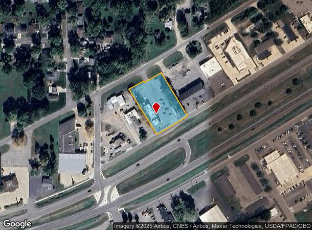
Property Record
2011 E Main St, Albert Lea, MN 56007

NEARBY LISTINGS FOR SALE OR LEASE
Property Detail
2011 E Main St
Albert Lea, MN
Buschbom Second Addition
34.245.0040
BUSCHBOM SECOND ADDITION LOT-002 BLOCK-002 LOT 2 BLK 2 BUSCHBOM SECOND ADDITION BURGER KING STORE #2641
Commercialnec
Freeborn
X
Minnesota
27047C0239C
2
2025
1.32 AC
2025
Minnesota South Area
180600
Other Market Areas
DEMOGRAPHICS near 2011 E Main St
1 Mile
3 Mile
5 Mile
2024 Total Population
2,938
18,222
20,652
2029 Population
2,902
18,164
20,601
Pop Growth 2024-2029
(1.23%)
(0.32%)
(0.25%)
Average Age
41
42
43
2024 Total Households
1,277
7,811
8,804
HH Growth 2024-2029
(1.33%)
(0.31%)
(0.25%)
Median Household Inc
$54,432
$52,089
$54,941
Avg Household Size
2.20
2.20
2.20
2024 Avg HH Vehicles
2.00
2.00
2.00
Median Home Value
$91,170
$123,655
$133,982
Median Year Built
1956
1958
1959
Nearby Places
Map Layers
Map Styles
 Street
 Aerial
- Restaurants
- Banks
- Shops
- Fitness
- Groceries
SALE & LEASE HISTORY
LISTING DATE
SALE/LEASE

Sep 24, 2016
For Sale
Nearby Properties
Address
Land Use
TOTAL SIZE
Lot Size
Zoning
Address
Land Use
TOTAL SIZE
Lot Size
Zoning
8.30 AC
PD
Address
Land Use
TOTAL SIZE
Lot Size
Zoning
26.38 AC
Address
Land Use
TOTAL SIZE
Lot Size
Zoning
2.01 AC
B3
Address
Land Use
TOTAL SIZE
Lot Size
Zoning
21.14 AC
Address
Land Use
TOTAL SIZE
Lot Size
Zoning
81.57 AC
I1
Address
Land Use
TOTAL SIZE
Lot Size
Zoning
5.41 AC
PD
Address
Land Use
TOTAL SIZE
Lot Size
Zoning
15.50 AC
Address
Land Use
TOTAL SIZE
Lot Size
Zoning
16.79 AC
B2
Address
Land Use
TOTAL SIZE
Lot Size
Zoning
6.96 AC
I2
Address
Land Use
TOTAL SIZE
Lot Size
Zoning
Address
Land Use
TOTAL SIZE
Lot Size
Zoning
5.68 AC
PD
Address
Land Use
TOTAL SIZE
Lot Size
Zoning
69,582 SF
12.88 AC
B2
Address
Land Use
TOTAL SIZE
Lot Size
Zoning
Address
Land Use
TOTAL SIZE
Lot Size
Zoning
Address
Land Use
TOTAL SIZE
Lot Size
Zoning
31.20 AC
IDD
Address
Land Use
TOTAL SIZE
Lot Size
Zoning
0.88 AC
R3
Address
Land Use
TOTAL SIZE
Lot Size
Zoning
247,732 SF
13.04 AC
I2
Address
Land Use
TOTAL SIZE
Lot Size
Zoning
11.71 AC
B2
Address
Land Use
TOTAL SIZE
Lot Size
Zoning
4.98 AC
Address
Land Use
TOTAL SIZE
Lot Size
Zoning
4.87 AC
I2
Address
Land Use
TOTAL SIZE
Lot Size
Zoning
2.51 AC
R3
Address
Land Use
TOTAL SIZE
Lot Size
Zoning
9.37 AC
I2
Address
Land Use
TOTAL SIZE
Lot Size
Zoning
12.80 AC
PD
Address
Land Use
TOTAL SIZE
Lot Size
Zoning
0.26 AC
B3
Address
Land Use
TOTAL SIZE
Lot Size
Zoning
6.64 AC
PD
Address
Land Use
TOTAL SIZE
Lot Size
Zoning
1.71 AC
PD
Address
Land Use
TOTAL SIZE
Lot Size
Zoning
2.90 AC
R3
Address
Land Use
TOTAL SIZE
Lot Size
Zoning
0.29 AC
Address
Land Use
TOTAL SIZE
Lot Size
Zoning
14.73 AC
B4
The World's #1 Commercial Real Estate Marketplace
Connect with us
© 2026 CoStar Group
The information above has been obtained from sources believed reliable. While we do not doubt its accuracy we have not verified it and make no guarantee, warranty or representation about it. It is your responsibility to independently confirm its accuracy and completeness. Any projections, opinions, assumptions, or estimates used are for example only and do not represent the current or future performance of the property. The value of this transaction to you depends on tax and other factors which should be evaluated by your tax, financial, and legal advisors. You and your advisors should conduct a careful, independent investigation of the property to determine to your satisfaction the suitability of the property for your needs.