Property Record
2011 Ridge Rd, Raleigh, NC 27607


NEARBY LISTINGS FOR SALE OR LEASE
-
-
View all Raleigh listings for sale on LoopNet.com
Property Detail
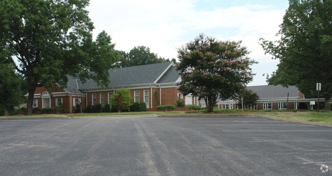
2011 Ridge Rd
Raleigh/Durham
Ridge Road Baptist Church
Raleigh-Cary, NC
LO1 RIDGE ROAD BAPTIST CHURCH RCMB BM202
0795.14-42-6725-000
Wake
Religious
North Carolina
0
1
2025
4.23 AC
051501
West Raleigh
34,681 SF
DEMOGRAPHICS near 2011 Ridge Rd
1 Mile
3 Mile
5 Mile
2024 Total Population
9,200
96,185
247,919
2029 Population
10,036
104,746
269,693
Pop Growth 2024-2029
+ 9.09%
+ 8.90%
+ 8.78%
Average Age
42
38
37
2024 Total Households
4,128
42,838
111,997
HH Growth 2024-2029
+ 9.21%
+ 9.49%
+ 9.13%
Median Household Inc
$116,402
$87,256
$73,163
Avg Household Size
2.20
2.00
2.00
2024 Avg HH Vehicles
2.00
2.00
2.00
Median Home Value
$698,622
$612,778
$431,629
Median Year Built
1979
1988
1987
Nearby Places
Map Layers
Map Styles
 Street
 Aerial
- Restaurants
- Banks
- Shops
- Fitness
- Groceries
PUBLIC TRANSPORTATION
COMMUTER RAIL
Raleigh Union Station (Piedmont - North Carolina by Train (NC Train))
DRIVE
WALK
Distance
Raleigh Union Station (Piedmont - North Carolina by Train (NC Train))
10 min
4.2 mi
Cary Station (Piedmont - North Carolina by Train (NC Train))
DRIVE
WALK
Distance
Cary Station (Piedmont - North Carolina by Train (NC Train))
15 min
8.1 mi
AIRPORT
Raleigh-Durham International
DRIVE
WALK
Distance
Raleigh-Durham International
18 min
10.8 mi
Nearby Properties
Address
Land Use
TOTAL SIZE
Lot Size
Zoning
Address
Land Use
TOTAL SIZE
Lot Size
Zoning
5,616,802 SF
507.97 AC
OX-12
Address
Land Use
TOTAL SIZE
Lot Size
Zoning
1,801,169 SF
59.60 AC
OX-12
Address
Land Use
TOTAL SIZE
Lot Size
Zoning
770,311 SF
80.70 AC
PD
Address
Land Use
TOTAL SIZE
Lot Size
Zoning
854,180 SF
210.81 AC
OX-4
Address
Land Use
TOTAL SIZE
Lot Size
Zoning
294,812 SF
999.47 AC
AP
Address
Land Use
TOTAL SIZE
Lot Size
Zoning
613,087 SF
266.85 AC
PD
Address
Land Use
TOTAL SIZE
Lot Size
Zoning
1,810,132 SF
OX-12
Address
Land Use
TOTAL SIZE
Lot Size
Zoning
12,850 SF
96.80 AC
OX-12
Address
Land Use
TOTAL SIZE
Lot Size
Zoning
2,804,942 SF
57.23 AC
CX-12
Address
Land Use
TOTAL SIZE
Lot Size
Zoning
403,230 SF
197.34 AC
IX-3
Address
Land Use
TOTAL SIZE
Lot Size
Zoning
250,448 SF
25.28 AC
OX-3
Address
Land Use
TOTAL SIZE
Lot Size
Zoning
1,039,527 SF
22.85 AC
OX-7
Address
Land Use
TOTAL SIZE
Lot Size
Zoning
524,391 SF
4.13 AC
NX-5
Address
Land Use
TOTAL SIZE
Lot Size
Zoning
658,580 SF
3.30 AC
PD
Address
Land Use
TOTAL SIZE
Lot Size
Zoning
747,658 SF
11.12 AC
CX-12
Address
Land Use
TOTAL SIZE
Lot Size
Zoning
465,052 SF
2.65 AC
PD
Address
Land Use
TOTAL SIZE
Lot Size
Zoning
364,025 SF
2.19 AC
PD
Address
Land Use
TOTAL SIZE
Lot Size
Zoning
834,950 SF
3.91 AC
OX-12
Address
Land Use
TOTAL SIZE
Lot Size
Zoning
426,539 SF
2.90 AC
NX-5
Address
Land Use
TOTAL SIZE
Lot Size
Zoning
613,248 SF
2.20 AC
IND-2
Address
Land Use
TOTAL SIZE
Lot Size
Zoning
539,902 SF
1.28 AC
O&I-1
Address
Land Use
TOTAL SIZE
Lot Size
Zoning
482,597 SF
36.39 AC
RX-4
Address
Land Use
TOTAL SIZE
Lot Size
Zoning
580,268 SF
9.02 AC
PD
Address
Land Use
TOTAL SIZE
Lot Size
Zoning
495,697 SF
9.11 AC
OX-5
Address
Land Use
TOTAL SIZE
Lot Size
Zoning
544,122 SF
1.49 AC
PD
Address
Land Use
TOTAL SIZE
Lot Size
Zoning
355,931 SF
2.60 AC
PD
Address
Land Use
TOTAL SIZE
Lot Size
Zoning
284,958 SF
3.01 AC
PD
Address
Land Use
TOTAL SIZE
Lot Size
Zoning
390,365 SF
3.70 AC
OX-5
Address
Land Use
TOTAL SIZE
Lot Size
Zoning
506,411 SF
2.52 AC
DX-12
Address
Land Use
TOTAL SIZE
Lot Size
Zoning
332,378 SF
2.83 AC
NX-5
The World's #1 Commercial Real Estate Marketplace
Connect with us
© 2026 CoStar Group
The information above has been obtained from sources believed reliable. While we do not doubt its accuracy we have not verified it and make no guarantee, warranty or representation about it. It is your responsibility to independently confirm its accuracy and completeness. Any projections, opinions, assumptions, or estimates used are for example only and do not represent the current or future performance of the property. The value of this transaction to you depends on tax and other factors which should be evaluated by your tax, financial, and legal advisors. You and your advisors should conduct a careful, independent investigation of the property to determine to your satisfaction the suitability of the property for your needs.