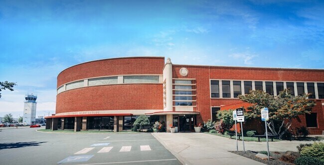
Property Record
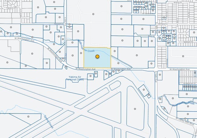
2011 W Washington Ave, Yakima, WA 98903

NEARBY LISTINGS FOR SALE OR LEASE
-
-
View all Yakima listings for sale on LoopNet.com
Property Detail
2011 W Washington Ave
181335-13008
Short Plat 85-82
Publichealthcarefacility
S 632.94 FT OF E 792 FT OF SW1/4 NE1/4 EX BEG NE COR,TH N 89^4140W 112.53 FT TH S 46^E 23.9 FT, TH E 95.4 FT,TH N 16 FT TO BEG EX S 30 FT RD R/W
AE
Yakima
53077C1033F
Washington
2025
11 AC
2025
Greater Yakima
001100
Yakima
152,588 SF
Yakima, WA
DEMOGRAPHICS near 2011 W Washington Ave
1 Mile
3 Mile
5 Mile
2024 Total Population
8,938
76,061
117,939
2029 Population
8,988
76,363
118,825
Pop Growth 2024-2029
+ 0.56%
+ 0.40%
+ 0.75%
Average Age
34
37
37
2024 Total Households
2,925
27,558
43,003
HH Growth 2024-2029
+ 0.48%
+ 0.43%
+ 0.75%
Median Household Inc
$53,187
$50,063
$54,610
Avg Household Size
2.90
2.60
2.60
2024 Avg HH Vehicles
2.00
2.00
2.00
Median Home Value
$197,618
$229,116
$252,785
Median Year Built
1971
1967
1972
Nearby Places
Map Layers
Map Styles
 Street
 Aerial
- Restaurants
- Banks
- Shops
- Fitness
- Groceries
PUBLIC TRANSPORTATION
AIRPORT
Yakima Air Trml/McAllister Field
DRIVE
WALK
Distance
Yakima Air Trml/McAllister Field
2 min
0.4 mi
Nearby Properties
Address
Land Use
TOTAL SIZE
Lot Size
Zoning
Address
Land Use
TOTAL SIZE
Lot Size
Zoning
331,736 SF
34.95 AC
R1
Address
Land Use
TOTAL SIZE
Lot Size
Zoning
390,527 SF
11.86 AC
R3
Address
Land Use
TOTAL SIZE
Lot Size
Zoning
409,453 SF
8.25 AC
R3
Address
Land Use
TOTAL SIZE
Lot Size
Zoning
326,323 SF
30.05 AC
R2
Address
Land Use
TOTAL SIZE
Lot Size
Zoning
347,665 SF
37.77 AC
B2
Address
Land Use
TOTAL SIZE
Lot Size
Zoning
193,955 SF
9.94 AC
C1
Address
Land Use
TOTAL SIZE
Lot Size
Zoning
208,322 SF
3.69 AC
PUB
Address
Land Use
TOTAL SIZE
Lot Size
Zoning
176,098 SF
1.67 AC
CBD
Address
Land Use
TOTAL SIZE
Lot Size
Zoning
106,878 SF
3.46 AC
RD
Address
Land Use
TOTAL SIZE
Lot Size
Zoning
329,388 SF
16.13 AC
M1
Address
Land Use
TOTAL SIZE
Lot Size
Zoning
205,680 SF
24.88 AC
C1
Address
Land Use
TOTAL SIZE
Lot Size
Zoning
345,698 SF
3.52 AC
C1
Address
Land Use
TOTAL SIZE
Lot Size
Zoning
65,606 SF
3.39 AC
R2
Address
Land Use
TOTAL SIZE
Lot Size
Zoning
91,856 SF
9.17 AC
RD
Address
Land Use
TOTAL SIZE
Lot Size
Zoning
114,192 SF
5.07 AC
C1
Address
Land Use
TOTAL SIZE
Lot Size
Zoning
132,213 SF
4 AC
R3
Address
Land Use
TOTAL SIZE
Lot Size
Zoning
56,505 SF
2.75 AC
C1
Address
Land Use
TOTAL SIZE
Lot Size
Zoning
57,009 SF
212.58 AC
AS
Address
Land Use
TOTAL SIZE
Lot Size
Zoning
64,171 SF
48.08 AC
PUB
Address
Land Use
TOTAL SIZE
Lot Size
Zoning
158,890 SF
13.84 AC
B2
Address
Land Use
TOTAL SIZE
Lot Size
Zoning
105,756 SF
6.89 AC
R3
Address
Land Use
TOTAL SIZE
Lot Size
Zoning
128,789 SF
6.65 AC
R3
Address
Land Use
TOTAL SIZE
Lot Size
Zoning
135,634 SF
9.84 AC
C1
Address
Land Use
TOTAL SIZE
Lot Size
Zoning
99,000 SF
5.44 AC
C1
Address
Land Use
TOTAL SIZE
Lot Size
Zoning
97,976 SF
3.98 AC
SCC
Address
Land Use
TOTAL SIZE
Lot Size
Zoning
53,278 SF
5.44 AC
M1
Address
Land Use
TOTAL SIZE
Lot Size
Zoning
86,547 SF
4.41 AC
R3
Address
Land Use
TOTAL SIZE
Lot Size
Zoning
89,850 SF
14.03 AC
R1
Address
Land Use
TOTAL SIZE
Lot Size
Zoning
325,959 SF
11.95 AC
M2
The World's #1 Commercial Real Estate Marketplace
Connect with us
© 2026 CoStar Group
The information above has been obtained from sources believed reliable. While we do not doubt its accuracy we have not verified it and make no guarantee, warranty or representation about it. It is your responsibility to independently confirm its accuracy and completeness. Any projections, opinions, assumptions, or estimates used are for example only and do not represent the current or future performance of the property. The value of this transaction to you depends on tax and other factors which should be evaluated by your tax, financial, and legal advisors. You and your advisors should conduct a careful, independent investigation of the property to determine to your satisfaction the suitability of the property for your needs.