Property Record
2012 E Canal Dr, Turlock, CA 95380
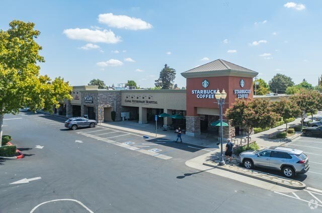
Property Detail
2012 E Canal Dr
051-28-49
MAP F4 75-79
Regionalshoppingcenterormallwithanchorstore
Stanislaus
B and X Area of moderate flood hazard, usually the area between the limits of the 100-year and 500-year floods.
California
2025
2.57 AC
2025
Turlock/SW Stanislaus
003802
Stockton/Modesto
32,793 SF
Modesto, CA
NEARBY LISTINGS FOR SALE OR LEASE
DEMOGRAPHICS near 2012 E Canal Dr
1 mile
3 mile
5 mile
2025 Total Population
12,895
76,739
89,789
2030 Population
13,019
77,901
90,915
Pop Growth 2025-2030
+ 0.96%
+ 1.51%
+ 1.25%
Average Age
39
38
38
2025 Total Households
4,726
25,672
29,759
HH Growth 2025-2030
+ 1.04%
+ 1.62%
+ 1.36%
Median Household Inc
$88,811
$84,219
$86,123
Avg Household Size
2.70
2.90
2.90
2025 Avg HH Vehicles
2.00
2.00
2.00
Median Home Value
$553,951
$469,088
$476,011
Median Year Built
1969
1981
1983
Nearby Places
Map Layers
Map Styles
 Street
 Aerial
Transit
 Traffic
 Biking
Places
Listings with unknown addresses are not visible on the map
- Restaurants
- Banks
- Shops
- Fitness
- Groceries
PUBLIC TRANSPORTATION
AIRPORT
Stockton Metro
Drive
Walk
Distance
Stockton Metro
54 min
39.2 mi
Freight Ports
Port of Stockton
Drive
Walk
Distance
Port of Stockton
62 min
47.7 mi
Nearby Properties
Address
Land Use
TOTAL SIZE
Lot Size
Zoning
Address
Land Use
TOTAL SIZE
Lot Size
Zoning
281,904 SF
17.84 AC
Address
Land Use
TOTAL SIZE
Lot Size
Zoning
557,040 SF
22.54 AC
TURI
Address
Land Use
TOTAL SIZE
Lot Size
Zoning
349,309 SF
21.87 AC
Address
Land Use
TOTAL SIZE
Lot Size
Zoning
128,000 SF
6.48 AC
Address
Land Use
TOTAL SIZE
Lot Size
Zoning
264,573 SF
9.47 AC
TURPD
Address
Land Use
TOTAL SIZE
Lot Size
Zoning
144,510 SF
12.04 AC
Address
Land Use
TOTAL SIZE
Lot Size
Zoning
244,740 SF
18.90 AC
Address
Land Use
TOTAL SIZE
Lot Size
Zoning
111,617 SF
10.10 AC
Address
Land Use
TOTAL SIZE
Lot Size
Zoning
81,953 SF
5 AC
M2
Address
Land Use
TOTAL SIZE
Lot Size
Zoning
149,310 SF
8.45 AC
Address
Land Use
TOTAL SIZE
Lot Size
Zoning
185,088 SF
9.08 AC
PD21
Address
Land Use
TOTAL SIZE
Lot Size
Zoning
302,449 SF
17.57 AC
Address
Land Use
TOTAL SIZE
Lot Size
Zoning
103,011 SF
7.90 AC
Address
Land Use
TOTAL SIZE
Lot Size
Zoning
112,779 SF
7.35 AC
TURCC
Address
Land Use
TOTAL SIZE
Lot Size
Zoning
68,015 SF
4.45 AC
CO
Address
Land Use
TOTAL SIZE
Lot Size
Zoning
55,955 SF
3.76 AC
TURRL
Address
Land Use
TOTAL SIZE
Lot Size
Zoning
111,357 SF
4.33 AC
TURCH
Address
Land Use
TOTAL SIZE
Lot Size
Zoning
140,482 SF
19.18 AC
Address
Land Use
TOTAL SIZE
Lot Size
Zoning
44,860 SF
2.93 AC
Address
Land Use
TOTAL SIZE
Lot Size
Zoning
57,788 SF
1.08 AC
TURPD
Address
Land Use
TOTAL SIZE
Lot Size
Zoning
69,842 SF
2.54 AC
TURRH
Address
Land Use
TOTAL SIZE
Lot Size
Zoning
124,591 SF
12.99 AC
Address
Land Use
TOTAL SIZE
Lot Size
Zoning
120,762 SF
9.39 AC
Address
Land Use
TOTAL SIZE
Lot Size
Zoning
110,184 SF
6.60 AC
Address
Land Use
TOTAL SIZE
Lot Size
Zoning
100,282 SF
8.40 AC
TURCC
Address
Land Use
TOTAL SIZE
Lot Size
Zoning
114,240 SF
6.06 AC
Address
Land Use
TOTAL SIZE
Lot Size
Zoning
66,981 SF
9.82 AC
Address
Land Use
TOTAL SIZE
Lot Size
Zoning
100,911 SF
14.88 AC
Address
Land Use
TOTAL SIZE
Lot Size
Zoning
49,250 SF
2.77 AC
Address
Land Use
TOTAL SIZE
Lot Size
Zoning
42,096 SF
3.17 AC
The World's #1 Commercial Real Estate Marketplace
Connect with us
© 2026 CoStar Group
The information above has been obtained from sources believed reliable. While we do not doubt its accuracy we have not verified it and make no guarantee, warranty or representation about it. It is your responsibility to independently confirm its accuracy and completeness. Any projections, opinions, assumptions, or estimates used are for example only and do not represent the current or future performance of the property. The value of this transaction to you depends on tax and other factors which should be evaluated by your tax, financial, and legal advisors. You and your advisors should conduct a careful, independent investigation of the property to determine to your satisfaction the suitability of the property for your needs.