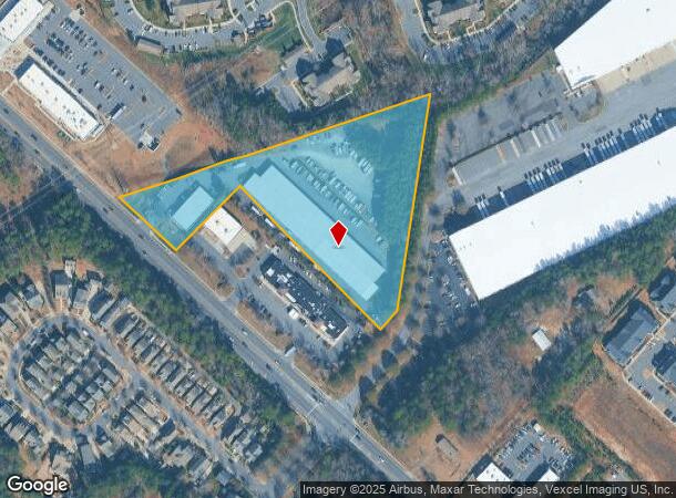
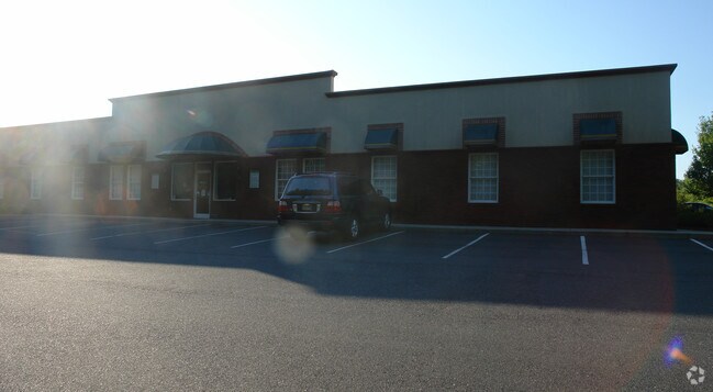
Property Record
2012 Highway 160 W, Fort Mill, SC 29708

NEARBY LISTINGS FOR SALE OR LEASE
Property Detail
2012 Highway 160 W
6530000009
Mw
Commercialnec
HWY 160 (6.10 AC)
X
York
45091C0211F
South Carolina
2025
6.10 AC
2025
York County
061011
Charlotte
77,000 SF
Charlotte-Concord-Gastonia, NC-SC
DEMOGRAPHICS near 2012 Highway 160 W
1 Mile
3 Mile
5 Mile
2024 Total Population
8,022
51,387
129,141
2029 Population
9,136
57,949
144,272
Pop Growth 2024-2029
+ 13.89%
+ 12.77%
+ 11.72%
Average Age
37
38
38
2024 Total Households
3,008
18,953
49,063
HH Growth 2024-2029
+ 14.16%
+ 13.08%
+ 11.94%
Median Household Inc
$106,845
$113,019
$101,068
Avg Household Size
2.70
2.70
2.60
2024 Avg HH Vehicles
2.00
2.00
2.00
Median Home Value
$417,794
$403,323
$367,153
Median Year Built
2010
2007
2005
Nearby Places
Map Layers
Map Styles
 Street
 Aerial
- Restaurants
- Banks
- Shops
- Fitness
- Groceries
PUBLIC TRANSPORTATION
AIRPORT
Charlotte/Douglas International
DRIVE
WALK
Distance
Charlotte/Douglas International
28 min
14.5 mi
Concord-Padgett Regional
DRIVE
WALK
Distance
Concord-Padgett Regional
48 min
33.6 mi
Freight Ports
North Charleston Terminal
DRIVE
WALK
Distance
North Charleston Terminal
208 min
184.6 mi
Nearby Properties
Address
Land Use
TOTAL SIZE
Lot Size
Zoning
Address
Land Use
TOTAL SIZE
Lot Size
Zoning
151,844 SF
11.65 AC
Address
Land Use
TOTAL SIZE
Lot Size
Zoning
401.79 AC
Address
Land Use
TOTAL SIZE
Lot Size
Zoning
335.85 AC
AGC
Address
Land Use
TOTAL SIZE
Lot Size
Zoning
790,440 SF
53.19 AC
Address
Land Use
TOTAL SIZE
Lot Size
Zoning
178,585 SF
17.44 AC
Address
Land Use
TOTAL SIZE
Lot Size
Zoning
2,476 SF
88.14 AC
Address
Land Use
TOTAL SIZE
Lot Size
Zoning
162.78 AC
RCI
Address
Land Use
TOTAL SIZE
Lot Size
Zoning
64,113 SF
6.69 AC
Address
Land Use
TOTAL SIZE
Lot Size
Zoning
197,864 SF
39.37 AC
Address
Land Use
TOTAL SIZE
Lot Size
Zoning
79,600 SF
9.58 AC
Address
Land Use
TOTAL SIZE
Lot Size
Zoning
11,056 SF
1.89 AC
RDI
Address
Land Use
TOTAL SIZE
Lot Size
Zoning
26,733 SF
34.66 AC
PD
Address
Land Use
TOTAL SIZE
Lot Size
Zoning
45.75 AC
RDI
Address
Land Use
TOTAL SIZE
Lot Size
Zoning
38,954 SF
21.23 AC
BDIII
Address
Land Use
TOTAL SIZE
Lot Size
Zoning
81,700 SF
43.75 AC
Address
Land Use
TOTAL SIZE
Lot Size
Zoning
2,238 SF
38.21 AC
RCI
Address
Land Use
TOTAL SIZE
Lot Size
Zoning
25,554 SF
14.18 AC
PD
Address
Land Use
TOTAL SIZE
Lot Size
Zoning
33,312 SF
14.71 AC
Address
Land Use
TOTAL SIZE
Lot Size
Zoning
131,716 SF
13.89 AC
Address
Land Use
TOTAL SIZE
Lot Size
Zoning
17,304 SF
3.30 AC
BDII
Address
Land Use
TOTAL SIZE
Lot Size
Zoning
155,948 SF
17.02 AC
UD
Address
Land Use
TOTAL SIZE
Lot Size
Zoning
48,912 SF
14.66 AC
Address
Land Use
TOTAL SIZE
Lot Size
Zoning
27,436 SF
16.85 AC
BDI
Address
Land Use
TOTAL SIZE
Lot Size
Zoning
250,903 SF
16.52 AC
BDII
Address
Land Use
TOTAL SIZE
Lot Size
Zoning
32,564 SF
13.44 AC
PD
Address
Land Use
TOTAL SIZE
Lot Size
Zoning
280,000 SF
35.63 AC
ID
Address
Land Use
TOTAL SIZE
Lot Size
Zoning
10.57 AC
Address
Land Use
TOTAL SIZE
Lot Size
Zoning
39,312 SF
13.11 AC
Address
Land Use
TOTAL SIZE
Lot Size
Zoning
24,200 SF
2.18 AC
Address
Land Use
TOTAL SIZE
Lot Size
Zoning
4,058 SF
28.55 AC
AGC
The World's #1 Commercial Real Estate Marketplace
Connect with us
© 2026 CoStar Group
The information above has been obtained from sources believed reliable. While we do not doubt its accuracy we have not verified it and make no guarantee, warranty or representation about it. It is your responsibility to independently confirm its accuracy and completeness. Any projections, opinions, assumptions, or estimates used are for example only and do not represent the current or future performance of the property. The value of this transaction to you depends on tax and other factors which should be evaluated by your tax, financial, and legal advisors. You and your advisors should conduct a careful, independent investigation of the property to determine to your satisfaction the suitability of the property for your needs.